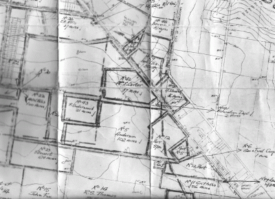
PORTION OF THE MAP SHOWING ACQUISITIONS FOR TULLAMARINE AIRPORT CIRCA 1960, AND LOCATIONS OF NOW-CLOSED LANES.
I often refer to this map. When I left Tullamarine for Rosebud, along with several parish maps and documents such as the Tullamarine Methodist Church centenary souvenir of 1970 and the Tullamarine Progress Association proposal of 1926 to relocate the Newmarket Saleyards to Tullamarine, it was left in the custody of the Hume Global Learning Centre at Broadmeadows. When Dr. Arun Chandu was writing his thesis on the planning of the airport he was not able to access much of my material so I hope the library has now lifted its game.
The attached map is valuable in explaining the lanes frequently mentioned by me in relation to locations of properties in Tullamarine. At the bottom right hand corner of the map is the Tullamarine Reserve at the north corner of today's Melrose Drive and Derby St. Derby St, known to locals as the back lane was part of Riddell and Hamilton's Camieston Estate, which being east of Melrose Drive, was in the Shire of Broadmeadows. The other subdivisional streets in the Camieston Estate were Nash's Lane (Victoria Rd on the plan) and Wright's Lane (Riddell Rd on the plan.) West of Nash's Lane (the southern end of which now Mercers Drive on the airport side of the freeway)was a wedge-shaped block sold to William Love Senior and tapering from wide on Bulla Rd (the Paul Ellis block) to almost a point at Moonee Ponds Creek. Next was "Glendewar", established by William Dewar, whose Bulla Rd frontage extended to the middle of Melway 5B4.
Nash's Lane met Bulla Rd at a right angle. This 200 metre portion of Nash's Lane was the north west boundary of Hamilton Terrace (between Bulla Rd and Derby St)which was divided into one acre blocks (20m x 200 metre depth) except for a triangular block on the south side of the Derby St/Melrose Drive corner which was owned in latter pre-suburban days by Andy Craig. The acre blocks were consolidated by a small number of people such as Noah Holland. After his death, no rates were being paid on his six blocks on the other side of the Derby St corner and Alec Rasmussen, secretary of the Tullamarine Progress Association suggested the body should gain title through adverse possession by paying the rates on them. It did so, and presented what is now the Melrose Drive reserve to Broadmeadows Shire in 1929.
Derby St separated Hamilton Terrace blocks from farmlet blocks and Chandos of 467 acres purchased by John Peter. Chandos fronted Broadmeadows Rd (later Old Broadmeadows Rd and now Mickleham Rd)from just south of the Freight Rd corner to the Moonee Ponds Creek. Derby St formed its south west boundary and Wright St its west boundary to the creek. The land between Wrights Lane and Nashs Lane north of Derby St was divided into 31 blocks of roughly 10 acres each with many of these being consolidated as Charles Nash's Fairview and Wallis Wright's Sunnyside.
On the acquisitions map, Nash's Lane is the south east boundary of the PAUL ELLIS block. It then heads north to the Moonee Ponds Creek just to the right of the crease in the map.
The land on the southwest side of Bulla Rd. north to Grants Lane, became part of the Shire of Keilor. The border with Bulla Shire was Grants Lane while Nash's Lane separated Bulla and Broadmeadows Shires.
The three subdivision lanes heading west to give access to farmlets on the Keilor side of Bulla Rd were, from south to north, Post Office Lane, Anderson's Lane and Conders Lane. (POSTSCRIPT. The map reveals a fourth lane heading west to form the south boundary of Bill Ellis's Ecclesfield before turning south to become the east boundary of the other portion of the L shaped (rotated 90 degrees clockwise) property, number 22 on the map. My memory is fairly good but not at 5:30 in the morning when I wrote the paragraph at the end about Ecclesfield. It wasn't Farnes' Lane that had been mentioned by Keith McNab about 29 years ago but SPIERS' LANE. See end of journal.)
Post Office Lane was the boundary between section 3 Tullamarine and J.P.Fawkner's subdivision of the parts of section 6/7 on the Keilor side of Bulla Rd. It is now the northern boundary of the Trade park industrial estate, heading west from a point directly opposite the Melrose Drive/ Derby St corner.
Anderson's Lane was just south of opposite the Wright's Lane corner. The reason for the name can be seen by the land owned by the Andersons when purchased circa 1961.
Conders Lane was the south boundary of the Tullamarine State School 2613 site and Mrs Carter's block surrounding it. The 57 acre Parr property, The Elms,extended from Andersons Lane to Conders Lane.
Grants Lane was a Government road and ran west from Bulla Rd to McNabs Rd. The eastern portion from Ellis's Corner has been renamed Melrose Drive to prevent confusion to motorists. Bill Ellis was unrelated to the Greek Paul Ellis who'd married a Chambers girl of Glendewar.
Bill owned Ecclesfield at the south corner of Grants Rd and on the east side of a lane heading south. Bill Ellis also owned part of Gowrie Park (north of Grants Rd) which is now the operational area of the airport. Bill's daughters, Vivian Sutherland and Jean Schwartz remained in Tullamarine, living opposite the now-demolished Tullamarine Methodist Church (north corner of Trade Park Drive.)
THE FOURTH SUBDIVISIONAL LANE HEADING WEST FROM BULLA RD. MUST HAVE BEEN SPIERS' LANE.
From the first (1868) available Keilor ratebook in the strongroom at Keilor to which I was given access by the rates officer, Adrian Dodoro, since a long-time recruiting officer of the Essendon Football Club, there was a 101 acre property owned by James Spiers, Peter Spiers and then Bill Ellis, the only property in the Tullamarine Riding of that size. It was Keith McNab who mentioned Spiers Lane 29 years ago and because he retired early at night, I never got around to specifying its location, having forgotten to do so in a subsequent interview.
James Spiers was trampled to death in 1869 by a dray pulled by a team of horses he was leading along.
(P.12, Advocate,9-10-1869.)
Peter Spiers committed suicide in 1911. (Countless sources.)
The 101 acre property was an L shaped (rotated 90 degrees clockwise) farm fronting the north (Grants Rd)and west boundaries of J.P.Fawkner's section 6 and 7 subdivision. It was lot 22 on the acquisitions map. The Grants Rd portion was bounded on the south by a lane heading west from Bulla Rd and the portion adjoining section 8 Tullamarine (McNab's Oakbank and Grant's Seafield)was bounded on the east by the same lane which turned south.
As this lane formed two boundaries of the Spiers/ Ellis farm, there is little doubt that it was SPIERS LANE.
Names of other north-south lanes on Fawkner's have never been discovered although Harry Heaps told me that Anderson's Lane turned north.
 by itellya
 Profile |
  Research |
 Contact | Subscribe | Block this user
 on 2017-11-04 15:54:38
Itellya is researching local history on the Mornington Peninsula and is willing to help family historians with information about the area between Somerville and Blairgowrie. He has extensive information about Henry Gomm of Somerville, Joseph Porta (Victoria's first bellows manufacturer) and Captain Adams of Rosebud.