itellya on Family Tree Circles
Journals and Posts
"TEENIE" GIBSON MARRIED DROMANA'S CONSTABLE (VIC., AUST.)
"Teenie" Gibson (No details on page 82 of A DREAMTIME OF DROMANA.)
O'SHANNASSY -On the 31st March at the residence of her son T P O'Shannassy, Manangatang, Christina, relict of the late William O'Shannassy, Tyrrell Downs, and daughter of the the late Walter Gibson, Dromana aged 83 years.(P.13, Argus, 24-3-1934.)
EventMarriage Event registration number4241 Registration year1869
Personal information
Family nameGIBSON Given namesChristina Nelson Rutherford SexUnknown Spouse's family nameOSHANASSY Spouse's given namesWilliam Vincent
DON'T TELL ME SHE MARRIED THE LOCAL (Dromana) POLICEMAN!
EventBirth Event registration number2121 Registration year1871
Personal information
Family nameOSHANNASSY Given namesWilliam Rutherford SexUnknown Father's nameWilliam Mother's nameChristina Nelson (Gibson) Place of birthDROM
The following well-deserved recognition of the services rendered by the undermentioned police constables at the prize fight catastrophe at Dromana appears in this week's Police Gazette: —
" To Constables William O'Shannassy,at Dromana, and George Stephens, at Mornington, Bourke district, £5 each has been awarded in acknowledgment of their services in saving human life on the occasion of a boat accident in July last."
(http://trove.nla.gov.au/newspaper/article/198657742) 1867.
Arising from the 1867 Dromana tragedy, William was a witness in Father Niall's trial in 1869.
CRIMINAL CHARGE AGAINST THE REV. PATRICK NIALL.
The Argus (Melbourne, Vic. : 1848 - 1957) Monday 13 September 1869 p 6 Article
... . Mr. Scurfield was in the room at the time. Constable O'Shannassy came in after the prisoner had had ... wished to speak to me privately. Mis. Scurfield and Constable O'Shannassy were in the room at the time ...
DEATH.
It is with deep regret that we have to announce the death of Mr W. R.O'Shannassy. The young man, who was only 28* years of age, recently came from Sea Lake, where his parents reside, to Dromana for the benefit of his health, and has been staying with his relations at 'Glen Holme.'(Glenholm!)Unfortunately the expected improve-
ment in his health did not take place, and he passed away on Tuesday. Much sympathy is felt for the parents
and relations in their sad loss.(P.2, Mornington Standard, 20-4-1912.)
The above was not William Rutherford O'Shannassy. His given names were Francis Rutherford.
O'SHANNASSY.-On the 16th April, at his grandfather's residence, "Glenholm," Dromana, Francis* Rutherford, fourth son of William and Christina O'Shannassy, Tyrrell Downs. (P.1, The Age, 18-4-1912.)
WILLIAM'S 1916 OBITUARIES.(COPY LINKS INTO SEARCH BAR.)
http://trove.nla.gov.au/newspaper/article/92121551
http://trove.nla.gov.au/newspaper/article/120959880
This was the son at whose residence both William and Christina died.
EventBirth Event registration number8506 Registration year1875
Personal information
Family nameOSHANNASSY Given namesPeter Thomas SexUnknown Father's nameWilliam Vincen Mother's nameChristina (Gibson) Place of birthDROM
William Nelson was born in 1877 (reg. no. 2077) and William Rutherford in 1871 (reg. no. 2121.) If the latter was the one who died at Dromana in 1912, he would have been about 41, not 28.
William and Christina's other child listed on the Victorian BDM list of births was Lillian Clare Evelyn, born in 1880, Four sons and two daughters were mentioned in William's second obituary; if that was correct one son and one daughter have not been found.
Before I discovered Victorian BDM online, I was able to obtain some information about married women by googling maiden name, given name, married surname. As Christina was listed as the third child, Adam (1854-1937) being the first, on page 82 of A DREAMTIME OF DROMANA, I'd spent hours trying to find her birth notice on Victorian BDM. A GIBSON,CHRISTINA O'SHANNASSY search has produced details about Christina, William and their other daughter.
William Vincent O'Shannassy, Circa 1841 - 1916
William Vincent O'Shannassy was born circa 1841, to Peter O'Shannassy** and Mary O'Shannassy (born Kerrigan).
Peter was born in 1819, in Athenry, Galway, Ireland.
Mary was born in 1822, in Newpass, Westmeath, Ireland.
William had 4 siblings.
William married Christina Nelson Rutherford O'Shannassy (born Gibson) in 1869, at age 28 at marriage place.
Christina was born in 1851, in Kilbucho, Peeblesshire, Scotland.
They had one daughter: Edith* Ethel May Loader (born O'Shannassy).
William passed away in 1916, at age 75 at death place.
*See Edith's death and marriage records below.She was the daughter whose birth record wasn't found.
**William's father was a police sergeant. Extract from William's second obituary above.
" I much regret to record the death of a very much respected resident, Mr William V. O'Shannassy, late of Tyrrell Downs.
The deceased was a native of Dublin, and came to the colony at the early age of eight with his father, Sergeant O'Shannassy. In his youth Mr O'Shannassy joined the police force, and after a very creditable service of 26 years, the latter portion of which he was senior-constable, he retired to follow farming pursuits at Tyrrell Downs, where he lived for twenty years, coming in the early part of this year to reside on his property near his sons,Messrs. T. P. O'Shannassy, J.P.,and V* O'Shannassy."
*AHA, THE MISSING SON. HIS DEATH RECORD.
N.B. Christina's maiden surname is wrongly given as Nelson, which was one of her given names.
EventDeath Event registration number34034 Registration year1960
Personal information
Family nameOSHANNASSY Given namesVincent Rutherford SexMale Father's nameOSHANNASSY William Vincent Mother's nameChristina (Nelson) Place of birthBEULAH Place of deathSEA LAKE Age66
EDITH'S DEATH RECORD.
EventDeath Event registration number20308 Registration year1980
Personal information
Family nameLOADER Given namesEDITH ETHEL MAY SexUnknown Father's nameO'SHANNASSY WI Mother's nameChristina Place of birth Place of deathBAIR Age95
EDITH'S MARRIAGE RECORD.
EventMarriage Event registration number4511 Registration year1911
Personal information
Family nameOSHANNASSY Given namesEdith Ethel May SexUnknown Spouse's family nameLOADER Spouse's given namesJos Hy
While searching for Edith's marriage notice, I came across the 1915 farewell to William and Christina when they were leaving Tyrrell. William's experience, as a policeman FOR 26 YEARS, with official paperwork had made his assistance invaluable to his fellow settlers.
http://trove.nla.gov.au/newspaper/article/154325248
Although it is reasonable to assume that Edith died at Bairnsdale, it is also reasonable to assume that Edith and Joseph Henry Loader met, married and lived for quite some time in the Mallee. Their daughter, Edith (b. 1915), was the most successful Princess at Chillingollah in 1923.
http://trove.nla.gov.au/newspaper/article/23438708
http://trove.nla.gov.au/newspaper/article/171251590
"WOLFDENE" MORNINGTON, VICTORIA, AUSTRALIA: PUB &MURDER,RESIDENCE & TRANSIT OF VENUS, SCHOOL, CAMP.
I will leave it up to readers to research the use of Wolfdene by the military during W.W.2 and as a tourist destination, as there is little genealogy involved.
Links will have to be copied and pasted into your search bar to get maps and articles because I am just plain exhausted. This journal arose from a history that I compiled about the Village Glen sites at Rosebud West and between Strachans and Wilsons Rds at Mornington.
In short, Wolfdene began as the Mornington Hotel on crown allotment 46, parish of Moorooduc, between Brewery road (now Nunns Rd)and Adelaide St houseblocks, in the late 1850's. In mid December 1867, the licensee applied to transfer the licence to a house he was leasing in Main St, Mornington and a week later the building and 26.5 acres of land were offered for sale. Professor Wilson, after whom Wilsons Rd was named, may have bought it then and in 1874 he observed the transit of Venus, possibly from Venice Reserve, and died shortly afterwards. The property was leased by Mr Backhouse who ran the Mornington Grammar School on the Wolfdene property, which was sold by the Wilson trustees in 1882. The property was subdivided in 1920 and Naples St was first mentioned in 1929 in a family notice.
THE TRANSIT OF VENUS.
WP Wilson: an Australian casualty of the 1874 transit of ...
https://maas.museum/.../09/wp-wilson-an-australian-casualty-of-the-1874-transit-of-venus
May 9, 2012
By Nick Lomb
Woldene as it looks today. Thanks to the care of past and present owners, its appearance is almost unchanged from the time when Professor William Parkinson Wilson lived in this house at Mornington, Victoria, Australia, in the 1870s. Image and copyright Nick Lomb ©, all rights reserved
Yesterday (8 May 2012) I visited Mornington, a small town about 50 km south of Melbourne that is beautifully situated on the shore of Port Phillip Bay, to talk about the transit of Venus to the Mornington & District Historical Society. Of course, I began with William Parkinson Wilson, professor of mathematics at Melbourne University, who observed the 1874 transit from Mornington.
Wilson was born in Peterborough, Northamptonshire, England. The exact date does not appear to be known, but he was baptised on 1 February 1826. After attending a local grammar school, he went on to Cambridge as a sizar (a student who does some work in lieu of fees). There he was most successful, completing the Mathematical Tripos as Senior Wrangler. The Senior Wrangler was the top student in mathematics at the end of the third year undergraduate degree. They were highly celebrated and their names reported in the newspapers. Other Senior Wranglers include some of the best known people in the history of science such as John Herschel, Lord Rayleigh and Arthur Eddington.
In 1854 he was offered the position of professor of mathematics at the newly established University of Melbourne. He arrived at the end of January in the following year and gave the very first lecture at the university on 13 April. As well as mathematics Wilson taught physics including astronomy and set up a course in engineering.
Professor Wilson lived in rooms at the university, but he also maintained a house at Mornington. The house, named Wolfdene, had been built in 1858 and during its long history has had various uses including as a hotel and as a boarding school. In Wilson’s time access to Mornington was not easy, as it was only on horseback or by water, so he would normally only have stayed there out of university term.
On the day of the transit, like at Melbourne, the weather was poor at Mornington as there were ‘Dense clouds, with thunder and lightning.’ Though Wilson ‘had given up all hope’, he still set up the equipment in readiness at his observing site. He pointed the 4½ -inch (11.5-cm) Troughton & Simms telescope to where he expected the Sun to be and waited. Eventually, the clouds cleared sufficiently so that he could make out one edge of the Sun. Five minutes before internal contact he noted that the part of Venus off the Sun was outlined ‘by a narrow luminous arc.’ Three and a half hours later, just before egress or Venus moving off the Sun, the sky cleared though the clarity of view was not as good as previously.
📷
Nick Lomb at Mornington’s Venice Reserve, a possible site for Professor Wilson’s observations of the 9 December 1874 transit of Venus. Image and copyright Nick Lomb ©, all rights reserved
Strangely, the location of Professor Wilson’s observing site is unclear. It would be logical to assume that he observed from his home, which at that time had extensive associated grounds. However, as has been pointed out to me by Ian Sullivan of the Mornington Peninsula Astronomical Society, the coordinates that Wilson gave in the report of his observations, centre on a small and little-known park in Mornington, called Venice Reserve. Prior to modern GPS receivers, determining longitude was notoriously difficult and the difference between the longitudes of Wolfdene and the reserve could well be within the errors. Latitude should have been easier to measure, yet the difference in latitude between Wolfdene and the park seems too great to be explained by measurement errors. So maybe, for unknown reasons, he decided to make his observations from Venice Reserve or its vicinity.
📷
The gravestone of Professor William Parkinson Wilson in Mornington Cemetery. Image and copyright Nick Lomb ©, all rights reserved
Professor Wilson’s observations of the transit had a tragic ending. He had been in ill health for some time and after the transit complained about the heat and about being fatigued. Two days later his doctor was called by telegram to his Mornington home. Sadly, he died of a cerebral haemorrhage, a type of stroke, two hours before the doctor could reach him. Although what caused the stroke can never be known, it is reasonable to assume that the stress, excitement and exertion associated with the transit observations had contributed to the sad event. Like Chappe d’Auteroche in Mexico in the previous century, we can regard William Parkinson Wilson as a casualty of the transit of Venus.
HOW BIG WAS THE WOLFDENE ESTATE AT MORNINGTON?
Messrs. Byrne, Vale, and Co. report having sold
today, by public auction, at their rooms, Collins
street east, the following properties in the estate of
the late Professor Wilson, viz -Schnapper Point -
Marine family residence known as Wolfdene, together
with 26.5* acres of land, £900, allotment of land imme-
diately opposite the above, and facing Esplanade and
bay, containing 6a 1r 5p** , at £22 per acre, £138 3s.9d , Crown allotment 5 of section 23***. containing 74.5 acres, at £1 17s 6d. per acre. (P.6, Argus, 16-2-1882.)
*This is specified in the next advertisement as being c/a 46.
** See the earlier advertisement below. Opposite means across Nunns Rd. C/A 39 was 688 links (69 mm on Melway) along Nunns Rd from Wilsons Rd with a frontage of another 500 links. It can be stated emphatically that c/a 39 is now occupied by View St house blocks.
*** C/A 5, SECTION 23 indeed consisted of 74 acres 2 roods and was 1555 links (311 metres) south of Bentons Rd, and extending 1475 links (295 metres) farther south between Racecourse Rd and Balcombe Creek. Chateux Close and Jillian Way house blocks are just within the north and south boundaries.
MOOROODUC MAP:
https://nla.gov.au/nla.obj-232502739/view
THIS EARLIER ADVERTISEMENT IS WORTH INCLUDING because it confirms my belief that Wolfdene was crown allotment 46 between Alf Downward's Redwood and Nunns Rd., and it specifies the use of each room.
WEDNESDAY, FEBRUARY 15.
At Two O'Clock.
SCHNAPPER POINT.
BEAUTIFUL MARINE RESIDENCE and GROUNDS
known as " WOLFDENE,"
Formerly occupied by the late Professor Wilson.
Also,
TWO BLOCKS OF LAND,
Containing 6.5 Acres and 74.5 Acres respectively.
To persons on the lookout for a Seaside Residence,
Squatters, Retired Gentlemen, and others.
BYRNE, VALE, and Co. have received instructions
from the trustees in the estate of the late
Professor Wilson to SELL by PUBLIC AUCTION,
at their rooms, 64 and 66 Collins street east, on
Wednesday, 16th February, 1882, at two o'clock.
Lot 1.-All that piece of land comprising Crown
Allotment 46, Parish of Moorooduc, county of Mornlngton, containing 26.5 ACRES 2 ROODS,
CLOSE to the Schnapper Point steamboat pier and
the bay,
The land is laid out in lawn and flower garden,
kitchen garden, orchard, and paddocks ; the residence,
with verandah all round, contains dining and drawing
rooms, library, hall, 5? bedrooms, linen room, bath-
room, lumber room, kitchen, 2 pantries, servant's-
room, scullery; also detached kitchen, servant's room,
sitting room, billiard room, coachhouse, stable, harness-
room, and outbuildings.
Lot 2 comprises 6 a. 1 r. 5p.,being Crown Allotment 39, immediately opposite the residence, facing the Esplanade and bay.
Lot 3 contains 74a. 2r. being crown Allotment 5 of section 23.
Professor Wilson may have bought the Mornington Hotel in 1867 BUT HISTORY HAS TO MAKE SENSE!
If Professor Wilson had owned it from 1867 till 1882, how could Henry Howard's wife be running it in 1875 when Henry became a murderer.*
The only explanation would have to be that the licence had been transferred to new premises. AND IT WAS.
TO THE BENCH of MAGISTRATES, Mornington.
-I, HENRY HOWARD, the holder of a pub-
lican's licence for the house and premises known as
the Mornington Hotel, situated at Mornington, do
hereby give notlce that it is my intention to APPLY
to the justices, sitting at the Petty Sessions to be
holden at Mornington on Saturday, December 21, to
REMOVE the LICENCE and SIGN to a house now
rented by me, containing two slttingrooms and two
bedrooms, lately occupied by Mr. Cahill, bootmaker,
and situated in Main-street, Mornington.
Given under my hand, this seventh day of Decem-
ber, one thousand eight hundred and sixty-seven.
HENRY HOWARD. (P.8, Argus, 11-12-1867.)
The hotel was sold for 600 pounds about a week later.
*Henry Howard’s journey – from Mornington to Frankston to ...
peninsulaessence.com.au/henry-howards...to-frankston-to-the-gallows
I HAD A DREAM that Christopher Smith had told me that a Mr Wolfdene had bought the hotel and then my subconscious used the information that sons of Mr Kirk, barman at the Mornington Hotel had drowned to produce a sequel in which a Mr Wolfdene and his sons had perished in similar circumstances. That was why I sprang out of bed to search for a gentleman with this surname, Wolfdene being the only trove search term. My dreams are rubbish but always result in an amazing discovery when my curiosity is aroused. And here it is. I wonder if Mr Backhouse had been an acquaintance of the late Professor Wilson.
M0RNINGT0N GRAMMAR SCHOOL,
Wolfdene, Schnapper Point.
Principal
B. T. P. BACKHOUSE (Cornell University),
Assisted by a competent staff.
Special Advantages.-A spacious residence, com-
manding beautiful land and sea views; extensive play-
grounds (25 acres), unrivalled salubrity of climate,
home comforts, private dormitories.
Pupils are carefully prepared for the University
and public schools.
Reference is kindly permitted to the Hon. Mrs.
Bright*, Beleura, and to other parents of pupils.
Terms moderate.
Prospectus on application to principal, or Messrs.
Mullen and Robertson.
DUTIES RESUMED JULY 28.
(P.28, The Australasian, 19-7-1879.)
*Mrs Charles Bright was the daughter of Sir John Manners- Sutton, the Governor of Victoria, after whom Sidney Smith Crispo named his private village (in today's Blairgowrie) just west of Canterbury Jetty Rd, MANNERS-SUTTON, later renaming it Canterbury when Sir John became Viscount Canterbury. Sir John often visited his daughter and that is why Beleura blurbs and guides refer to Beleura having been a Vice Regal residence.
1920 SUBDIVISION OF WOLFDENE.
The subdivision of the property was probably the result of this expected death.
ZICHY-WOINARSKI.-On the 5th April, at Wood's Point, Slanislaus K. A. Zichy-Woinarski, formerly
of Ballarat, loved husband of Mrs. F. D.Zichy-Woinarski, "Wolfdene," Mornington.
(P., Argus, 7-4-1920.)
THIS SATURDAY (MARCH l8).
On the Property. At Half-past Two O'Clock.
In a Seated Marquee.
MORNINGTON, Close Fishermen's
MOHNINGTON Beach,
WOLFDENE ESTATE. WOLFDENE ESTATE
69 CHOICE ALLOTMENTS. 69,
69 CHOICE ALLOTMENTS 69.
WILSON'S ROAD, BREWERY ROAD, NAPLES,VENICE*, and NEPTUNE STREETS.
Also.
SUPERIOR W.B. VILLA, "WOLFDENE,"
About 10 Rooms, Bathroom, Return Verandah, W.B.Garage, Stables, Workshop, Laundry, Man's Room, &c.; Asphalt Tennis-court, in Perfect Order. Well Supplied with Water. Numerous Tanks and Underground Well, LAND, About 2.5 Acres .
Also,
WILSON'S ROAD (on Lot 7),-. "NANYLTA,"
Newly Erected W'.B. Cottage, All Lined with 3-ply Wood, Containing 5 Rooms, Verandah, Gas
Laid On, Gas-stove. LAND about 07 x 200. A Really Nice Seaside Cottage, in Thorough Order.
At the SAME TIME Will be SOLD for REMOVAL, A QUAINT JAPANESE TEAHOUSE,Imported from Japan, and Erected in Sections, with Shingle Roof; Cane Tables and Chairs.
Most Suitable for the Grounds of a Seaside Home, and is Quite Unique,
Also will be Offered at the Same Time (as it doesn't state "on the same account" or where on Pt Nepean Rd the almost 20 acres were, I have not bothered correcting the text.)
(P.2, Argus, 10-3-1920.)
*The Zichy-Woinarski family which had owned the Wolfdene property since 1901** was proud of its aristocratic Polish/Hungarian ancestry which had led to a relative's farm between Elizabeth Avenue and Truemans Rd, Rosebud West being given the noble name of Woyna, but even though they may have heard Alfred Downward, (of "Redwood" between Wolfdene and Pt Nepean Rd) speak about Venus, they might have thought he meant Venice and adopted a Mediterranean theme for their street names.
**Mr Stookes, of Mornington, has disposed of his handsome property "Wolfdene" to Dr Wionarski of Ballarat, at a very satisfactory price. It is Mr Stookes intention to remove to Melbourne.
(P.2, Mornington Standard, 10-10-1901.)
, TULLAMARINE TALES, VIC., AUST.
Research into Barbiston and William Grant, and then a "Hopetoun,Tullamarine" search led me to the man who changed his name. As I have spent countless hours trying to rediscover articles previously read, I prefer to use material as soon as I find it.
THE FACTS.
HOBBS - KOWARZIK. - June, only daughter of Mr. and Mrs. Hobbs, of Douglas, to Ken, only son of Mr. and Mrs.F.F. Kowarzik, of Tullamarine.(P.8, Argus,9-11-1946.)
AFTER the expiration of fourteen days from the publication hereof, application will be made to the Supreme Court of Victoria that PROBATE of the WILL, dated 14th January, 1941, of JOHN WALLIS MURRAY, late of 36 Waterdale rd.. Ivanhoe, in Victoria, chief steward, deceased, may be granted to Charles Fairfax Telford, hotel manager,
Temple Court Hotel, cnr. Queen and Little Collins streets, Melbourne, and Frederic Ferdinand Kowarzik, assistant manager, of Broadmeadows rd. Tullamarine, being the executors appointed by the said will.(P.16,Argus, 8-5-1947.)
KOWARZIK ?PALMER. ?Lorraine, only daughter of Mr. and Mrs. F. F. Kowarzik, Tullamarine, to Eric, only son of
Mr. and Mrs. C. Palmer, Tullamarine.(P.8, Argus, 7-2-1948.)
WINDFALL FOR AIRLINES ON "ROUTE FEES".Last night in Melbourne, Mr. F. F. Kowarzik, A.N.A.'s acting general manager, said the charges would now be withdrawn. (P.1, Argus, 13-8-1952.)
Mr. F. F. Kowarzik, previously assistant general manager for A.N.A., has been appointed general manager.
(PERSONAL. Examiner (Launceston, Tas. : 1900 - 1954) Thursday 30 July 1953 p 3 Article)
Plane Dealer Reports Us Offer For Ana - Google News
news.google.com/newspapers?nid=1301&dat...id=m...
PLANE DEALER REPORTS U.S. OFFER FOR A.N.A.
The general manager of A.N.A., Mr.F.F.Kaye, said in Melbourne last night that he wrote to Mr Howitt on August 2, acknowledging the offer. (P.1, Sydney Morning Herald, August 9, 1957.)
On 23-8-1857, Ansett-A.N.A.came into existence.
THE STORY.
When I saw "Kowarzic" (sic)in Broadmeadows rates replacing the Wrights on the northern half of Viewpoint, I idly thought that the name would be more likely to be found on the Triangular Estate (bounded by today's Melrose Dr.,Broadmeadows Rd and Sharps Rd/Caterpillar Dr.)where many migrants settled in the 1950's.Then I found the same person assessed on "Strathconan" across today's Mickleham Rd from Freight Rd to just north of the freeway.
The Fannings have lived on "Sunnyside" (south corner of Loemans and Bulla-Diggers Rest Rd) for over 150 years. You can find all about the Fannings on Kathleen Fanning's wonderful FANNING FAMILY website. Ed. Fanning told me much of the Fanning story and that of Tullamarine Island almost two decades ago. After his school days, Ed. worked at Essendon Aerodrome and out of the blue he mentioned a fellow called Kowarzik who lived on the way to the aerodrome, was general manager of A.N.A., was persuaded to change his name and was ditched by Reg. Ansett when Ansett A.N.A. was established. Oral history can lead to mistakes but without Ed's story, I would never have been able to trace Frederic's name change as illustrated above!
In about 1950 there were only four properties between the road to old Broadmeadows Township (Westmeadows) and the Moonee Ponds Creek from the Albion-Jacana railway bridge. They were Peter Cowan's dairy farm, "Gowanbrae", Palmer and Kowarzic on half each of "Viewpoint" and "Gladstone Park".
COWAN. - On August 30, at a private hospital, Moreland, Olive Beatrice, dearly beloved wife of Peter Cowan, of Gowan Brae, Tullamarine, late of Temora,N.S.W., and loving mother of Newell, Colin, Allan (deceased),
Jean (Mrs. Boon), and Olive (Mrs.Hayman), aged 68 years.(P.15,Argus,1-9-1955.)
The Cowan farm extended north to include Camp Hill Park opposite Green's corner (today's 711 garage.)
Charles Palmer's southern half of Viewpoint was formerly John Mansfield's "Grandview".
TULLAMARINE
THIS DAY. At Two O'Clock. CLEARING SALE of HORSES, CATTLE. FARMING IMPLEMENTS, 200TONS of HAY. &c.
On Account of Mr. JOHN MANSFIELD,"Grandview," Junction of Bulla and Broadmeadows Road, TULLAMARINE.
(P.2, Argus,27-3-1917.)
Charles Palmer had bought 166 acres south of Gladstone Park in 1945 32 pounds 10 shillings per acre and in 1958 Stanley Korman bought his farm at 500 pounds per acre. Ansell and Cowen's(sic) dairy farm to the south was bought by a Korman company at an even more inflated price.(P.195 BROADMEADOWS;A FORGOTTEN HISTORY.)
Korman had the four properties mentioned previously but went broke so when I started the Kindergarten Association paper drive in about 1972, Charles' widow,living in the old timber homestead north of the Shawlands Dr. corner was a most friendly and hospitable supplier of papers. The Kowarzik half of Viewpoint included Scampton Drive and adjoined "Gladstone Park" at the Lackenheath Dr. corner.The boundaries of Strathconan have been described earlier.
-----------------------------------
THE FACTS.
WEDNESDAY, JANUARY 4.
TULLAMARINE.
Sale by Public Auction of Freehold Farm (166 Acres),Stone Dwellinghouse and Outbuildings, Household Furniture, Milch Cows, Horses, Carts, Harness, Farming Implements, and Dairy Utensils.
By Order of the Mortgagees And The Executors of the late Mr. Thomas Faithful.
for Positive and Absolute Sale Without the Least Reserve.
ALFRED BLISS has been favoured with Instructions from the mortgagees of the property and the executors of the late Mr. Thomas Faithful to SELL by PUBLIC AUCTION, on the farm, Tullamarine (one mile and a half from the Bulla Hotel), on Wednesday, January 4, at one o'clock, All that valuable FARMING PROPERTY,Containing 166 ACRES,
Fenced In with posts and rails and wire, and divided into four paddocks, 40 acres this year under cultivation, and 10 acres rye grass, half an acre garden, and the remainder grazing ground, on which is erected A SUBSTANTIAL STONE HOUSE, containing four rooms, two rooms of wood in the rear, four-horse stable and chaffhouse, barn, stockyard, cowsheds, &c.
This farm is for absolute sale, on account of the death of Mr. Faithful. It has a frontage to Jackson's
Creek, and is surrounded by the properties of Messrs.Loeman, Stewart, Moses Faithful, Heagney, and Smith ;
has a metalled road to it, is 17 miles from Melbourne, one mile and a half from Bulla Hotel, and close to the
Tullamarine school. A very excellent farming property, with comfortable residence.
This lot will be sold by order of the mortgagees. (P.2, Argus, 31-12-1870.)
THE STORY.
Extracts from my EARLY LANDOWNERS: PARISH OF TULLAMARINE.
ABRAHAM HODGKINSON.
Abraham Hodgkinson was the 3rd mate on the ?Royal Consort? which left for Australia on 9-11-1843 and arrived on 18-2-1844. He was paid L8/19/6 for his duties, which indicates that he did not jump ship as many sailors did a decade later during the gold rush. On board as passengers were Thomas Faithfull 37, his wife Mary Ann 39, and their children: Harriet Ruby 19, Sarah Amelia 17, Henry 14, Jane 11, Moses 8, William 4 and Thomas 2. The Faithfull family must have soon arrived in this area for when their eighth and last child, Anne, was born on 9-6-1846 the birth was registered at Bulla.
Now it seems that Abraham Hogkinson, about 31 during the voyage out, was using his time off duty for more than sleeping. A certain 19 year old lass had caught his eye and he was to marry Harriet on 10-2-1850. Abraham was to live only nine years after his marriage but fathered eight children because he started early! Did they elope? The registrations of his childrens? births indicate his whereabouts before buying land on Tullamarine Island:
Ester b. Moonee Ponds* & d. Melbourne 1845, Maria b. Gippsland 1848, William b. Keilor 1849, Marian b.1851 and Sarah b.1853 at Jordans Creek (up Castlemaine way), Thomas b.1855 Tullamarine, Harriet b.1857 Flemington (may have needed special medical care for the birth), Abraham b.1860 Tullamarine (d.1861.)
(*This meant anywhere along the Moonee Ponds Creek.)
Several of Thomas Faithfull?s children married people who were or became residents on or near Tullamarine Island. The first, Harriet Ruby, married Abraham Hodgkinson on 10-2-1850, probably as the result of a Love Boat romance. Abraham was 3rd mate on the Royal Escort, on which the Faithfulls sailed to Australia in 1853-4, and must have made an impression on the 19 year old Harriet. Sarah Amelia married Henry Mildenhall who bought land from Abe Hodgkinson. Ann married David Mansfield of Roseleigh (later Glenalice just north of the e-w runway) just west of Deep Creek. The third daughter, Jane, married George Nicholls .
Henry Mildenhall is called Harry in title documents so it is possible that George Nicholls was the R.G.Nichols who bought lot 6 on section 10 for 120 pounds on 23-8-1854 and sold it to William Sharp(Harriet?s second husband) for only 60 pounds on 29-6-1865.(16 196 and 159 339)
Ann McArthur, who married William Faithfull, may have been a daughter of Peter McArthur, the grantee of the 338 acre ?Glenarthur?, which is now covered by the western half of the Greenvale Reservoir. Two of Harriet?s children, Thomas and Harriet Hodgkinson married locals:Harriet Bedford (lots 1-3 section 10) and Alexander Robb (lots 49-51 on 13B, east bank of Deep Creek.)
SECTION 11.
11 A. BULLA PARK.
Allotment A of section 11 was known to Bob Blackwell as Bulla Park. Its southern boundary, along Loemans Rd, is given in documents as 80 chains (a mile) but Melway shows it as 85 chains. This could be because the original survey was wrong or because Loemans Rd was moved 5 chains to the east at a later time. Its western boundary was 62.25 chains and its eastern boundary extended 40 chains north along Loemans Rd to the bend.
Thomas Faithfull bought the 333 acres from the grantees (Cay, Chapman and Kaye) for 1665 pounds on 26-7-1852. (21 821) On 10-9-1854, Thomas conveyed the eastern half of the allotment to his son, Moses, for L832/10/-. Its southern boundary went west 45 chains from the south east corner to compensate for the eastern boundary being only half a mile. (21 822)
Thomas kept the western half, which had a southern boundary of only 35 chains but its western boundary extended 62.25 chains north to the Saltwater River. He mortgaged it to Catherine McKinnon for 200 pounds on 16-5-1855 (26 587) and to John Catto for 200 pounds on 23-5-1857. (49 256) Moses mortgaged his portion to McKinnon for 200 pounds on 20-5-1857. (49 258)
----------------------------------------
THE FACTS.
SECTION No. 1, Tullamarine, tho property of Donald Cameron, Esq. Purchasers at the late auction sale by Mr. Dalmahoy Campbell, are hereby informed that a surveyor from the office of the undersigned will be in
attendance on Friday morning next, at 9 o'clock, to show their respective lots, which are now being pegged out. CHARLES LAING," surveyor, No. 20 Swanston-street, 21st February, 1854. 2151 24
(P.7, Argus, 24-2-1854.)
THE STORY.
Most of the early story of section 1, Tullamarine is told in my journal HOW GLENGYLE BECAME ARUNDEL.
In his architectural thesis on Arundel (circa 1960), K.B.Keeley stated that Richard Hanmer Bunbury, the grantee of the 907 acre estate on 9-1-1843, had acted as a dummy for Cameron and soon sold it to him. It would seem to be Donald Cameron who called it the Glengyle Estate. With a whole shipload of Camerons arriving in early times,it is unwise to speculate too much but Donald may have been an early squatter whose sheep had scab and wandered off infecting other flocks in the parish of Bolinda,according to Isaac Batey. He also may have been the grantee of "Stoney Fields" near Somerton, later renamed Ruthvenfield by his family and later again, Roxborough Park by Brunton.
Title memorials show that, almost immediately after a property was bought,it was mortgaged in most cases and that when it was cleared another mortgage would be take place. This was most likely the reason that Donald Cameron had been forced to sell off portions of section 1 as mentioned above by the surveyor. That obviously did not help him much because mortgagees were advertising what would seem to be the remaining portion in 1855.
Sales by Auction.
MONDAY, 18th JUNE.
To Farmers, Graziers, Hotelkeepers, Speculators and Others.
A Valuable Farm on the Saltwater River, near Keilor, Parish of Tullamarine, containing 468A. IR. 36P.
Also,The Caledonian Hotel, situated at Prahran. By Order of the Mortgagees.
SYMONS and PERRY have received instructions from the mortgagees to sell by public auction, at the Commercial Sales Room, on Monday, 18th inst., at twelve o'clock sharp,Without tho slightest Reserve,
All that valuable farm well known as the Glengyle Farm, Containing 468A. lR .36P., more or less, situated on the Saltwater River, being portion of the estate the property of Donald Cameron.Esq., being part of portion No. 1, parish of Tullamarine. There are from 150 to 200 acres in cultivation on the above farm, which are chiefly under crop, and the land is well known that, for richness of soil is unsurpassed by any in the colony.
(P.2, Argus, 12-6-1855.)
It was K.B.Keeley's contention that Bunbury had named Arundel and that Edward Wilson had sold off parts of the estate but as the above shows, Cameron named it Glengyle and sold off the portions that became Turner's, Ellengowan and Arundel.
The Glengyle Estate later formed most of the Arundel Closer Settlement except the eastern 1987 links (397 metres) of lots 7 and 8 (later Joe (Butcher) Thomas's "Tullamar") the eastern 4050 links (810 metres) of Alf Cock's"Glenview" on lot 10, and lot 9,known as Geraghty's Paddock.
.FAMILY TREE CIRCLES WORKS! TOOLAROO'S BOOK, "PENINSULA PIONEERS".
Today,I received a present from Toolaroo, a family tree circles member. Not only couldn't I put it down, it is extremely accurate. The only item that I would query is the spelling of the surname of Sarah Prosser who is quoted on page 22. It is possible that she was descended from Henry Prosser, a Frankston Fish Company director and Frankston and Hastings Shire councillor (whose daughter, Sarah, married Isaac Sawyer and, after his death, Amis Renouf) but she was more likely to be a descendant of Henry Prossor, who was in the parish of Fingal before moving to the Red Hill Village Settlement whose through road is called Prossors Lane.
The book is called PENINSULA PIONEERS which could be misleading as to the number of pioneering families discussed; the families discussed are in my surname list. Those marked with a star are just mentioned in articles and I will provide some information about them below.
LAKE/LEAK. That the two acre block (lot 86 of crown allotment 18, Wannaeue)had been already sold was pointed out in a loan document of 1879 detailing a loan from Captain Henry Everest Adams of Rosebud to William Edwards, a publican who established the Tanti Hotel in the 1850's; see my Tanti Hotel journal. Fisherman, Jack Jones of Rosebud, later had a store on this(the FJ's) corner. I was not aware that the Leak/Lake brothers had actually purchased crown allotment 18 from Blooming Bob White, but Frederick and William Leak were assessed on 150acres on 29-7-1889. For once the rate collector got it right! After the sale flopped because of the dispute over lot 86, Robert White was again assessed on 19-7-1890 and 18-7-1891.
The loan document stated that the block had been sold off by this chappie.
The Argus (Melbourne, Vic. : 1848 - 1957) Wednesday 18 February 1874 p 3 Advertising
... on .Saturday, February 21, at thrco o'clock. THURSDAY, FEBRUARY 26. BROADFORD. Wannaeue, County of Mornington. SALE by PUBLIC AUCTION Of 152a. 2r. 16p., Parish of Wannaeue, County of Mornington. And By Order of tho Executors of CHARLES BLAKEY, Deceased. For Positive and Absolute Sale. Without the ... 9204 words
Frederick and William Leak were later (about 1910 I think)in dispute with William Jamieson, a pioneer of the Rosebud Fishing Village, over what was probably part of that two acre block,but unfortunately due to shocking digitisation, I haven't been able to re-find the article. If I do stumble across it,it will be included in my EARLY ROSEBUD journal under crown allotment 18.
COLLINS and COLLINGS. Maiden names in the Robert White genealogy way back, in Scotland.
AULT. A Dromana carpenter who later bought 140 acres south of William Henry Blakely's 140 acres (which has the Red Hill Consolidated School in its north west corner) and west of James McKeown's grants. Henry Ault painted the original Red Hill School at the north end of Arkwells Lane in 1875 for seven pounds fifteen shillings.
(P.28 THE RED HILL.)
HILL. James McKeown, Red Hill Pioneer who moved to Gracefield in Dromana circa 1885, married Catherine Townsend Hill of Warrnambool.
CLEINE. Son in law of the McIlroys. See THE RED HILL.
HOPCRAFT. William and John Hopcraft were granted land either side of Mornington-Flinders Rd near the north end of Tucks Rd and were near the Hillis and Davey grants and Henry Ault's 140 acres.
KEMP. Red Hill pioneer who was granted land in the parish of Kangerong on the east corner of McIlroys and Bowrings Rds between Blooming Bob White's 27 acres and the McIlroys and Forest Lodge to the east.
SIMPSON. See Joseph Simpson in my pioneer pathway JOURNAL. McIlroy in law.
HUNTLEY. South of Little Bridge Farm and east of another McIlroy grant farmed by Charles Cleine. Joseph McIlroy leased the Huntley's Hillside Orchard for five years. Sir Thomas Bent married one of John Huntley Senior's daughters and Cr John Shand married John Huntley Jnr's widow, Mary (nee Hope.)
BENNETT. Farmed Seven Oaks and Kent Orchard south of Craig Avon Lane. William Rd near the ArthursSeat summit is named after A.E.Bennett's son and executor,William.
ANDERSON. Yetta Ward Anderson supplied an anecdote about William and Joseph McIlroy and their strawberries. (P.22.)
PROSSER. See above.
CAIRNS. See my numerous journals about this family. Maiden name in the Robert White genealogy. A Robert White was leasing a hut from the Cairns brothers at Boneo in 1864. Both families came from Clackmannan near Menstrie; Robert White senior died at Menstrie Hill, Rosebud and Alex Cairns called his grant "Menstrie Mains".
PATERSON.RUSSELL.Both of these are maiden names in the Robert White genealogy.Perhaps the Cairns, Patterson and Russell families of Wannaeue and Fingal, with so many marital connections,were neighbours near Clackmannan before they set off to Australia. See LAND IN WANNAEUE AND FINGAL OWNED BY THE CAIRNS AND THEIR IN-LAWS and the CAIRNS GENEALOGY journals.
DAVEY. James Davey was descended from the pioneering Davey family of Frankston. The Davey pre-emptive right in the parish of Frankston was on the beach side of Old Mornington Rd from the Sweetwater Creek Crossing (Dory's Gully)to Canadian Bay Rd. The Davey homestead "Marysville" was demolished when "Marathon" was built if my memory serves me correctly. James Davey was granted land in Kangerong (Forest Lodge), 14A Balnarring (the Shand/Huntley "Kentucky" and "Rosslyn", houses now 214 and 212 Bittern-Dromana Rd)and land east of White's Rd farmed by Bullocky Bob White (born Robert James), his wife Hannah (nee Roberts) and their descendants.
BULLOCKY BOB WHITE was Blooming Bob White's nephew and the detail about his name change is in my journal about HILL HILLIS AND THE TWO BOB WHITES but not in the book.
Toolaroo's book has fantastic maps showing all the land grants superimposed on present day maps. Who's heard of slavery in Scotland and farms smaller than a house block in Ireland. By the time I'd read about these things, I fully understood why our pioneers would want to leave their homeland and familiesforever. Cairns descendants would love this book because of the maps and articles about the Menstrie area. Even the information about the Kew Lunatic Asylum was of great interest.
I don't know whether toolaroo had enough copies printed to have some available for purchase, but it is a terrific book which fills a void in the knowledge of the history of the Red Hill/Rosebud area. The Mornington Peninsula library and the Dromana Historical Society must obtain copies. Send a private message to toolaroo if you wish to obtain a copy.
WHITE, McKEOWN, HILLIS, LAKE/LEAK*, McILROY, COLLINS*, COLLINGS*, AULT*, HILL*,CLEINE*, HOPCRAFT*, KEMP*,SIMPSON*,HUNTLEY*, BENNETT**, ANDERSON*, PROSSER/PROSSOR, SHARP*, CAIRNS*, PATERSON*, RUSSELL*, LYNCH,
1888 geography with the Melbourne Hunt: WEST ESSENDON, NIDDRIE, TULLAMARINE, STRATHMORE, VIC., AUST.
MY APOLOGIES FOR MANY VAGUE STATEMENTS IN THE FOLLOWING. FOR EXAMPLE,"GEORGE MANSFIELD BOUGHT DALKEITH IN ABOUT 1910. BECAUSE I CANNOT ACCESS ANY OF MY COMPUTER FILES (WHICH WOULD CONTAIN TITLE INFORMATION SUCH AS THE EXACT DATE) THIS JOURNAL IS WRITTEN ENTIRELY FROM MEMORY. WITHOUT THIS MEMORY, TROVE INFORMATION WOULD NEVER HAVE BEEN FOUND, FARM NAMES PROVIDED BY SUCH AS GORDON CONNOR, KEITH MCNAB, COLIN WILLIAMS, HARRY HEAPS, SID LLOYD, BOB BLACKWELL, EILEEN REDDAN, OLIVE NASH, WINNIE LEWIS (NEE PARR) ETC., BEING A KEY INGREDIENT IN THE SEARCH. LUCKILY I HAD "TULLAMARINE BEFORE THE JETPORT" ON PAPER AND SOME TITLES INFORMATION WAS TRANSPOSED ONTO MY 1999 MELWAY.
@@ 1888 @@
Later this year the Oaklands Hunt was formed and showed more respect for farmers than the Melbourne Hunt which had tended to trample crops and scare ewes so badly that they stopped lambing,such as at Edmund E.Dunn's "Viewpoint". I hope "Dunn v Waldock" a couple of decades earlier had improved the Melbourne mob's attitude.
THE MELBOURNE HUNT
The Melbourne- Hounds met at Essendon last Saturday and one of the best runs ever enjoyed by the members of the hunt ensued.There was a large gathering-quite 100 horsemen at starting-and a line of country was chosen that could not be surpassed. The throw off was at Tweedside, about half a mile from the railway station, and the course taken was over Mar Lodge Estate, through Budesbach into the late Mr James Wilson's property, across the Keilor road into Niddrie, along the back of Spring park through Sharpe's, Crotty's and Williamson's into Allandale, up by Tullamarine, over the Bulla road into Mr Dewar's property, in an easterly direction across the Broadmeadows- road into Mr Dunn's property, along through Messrs Lonie's, Hall's, Kernan's and Peck's
up to Mr Napier's, into Woodlands street, Essendon, where the hounds were stopped after a run of 14 miles, that would have delighted the heart of any true sportsman. (P.9, Argus,11-6-1888.)
TWEEDSIDE. (top half of Melway 28 E4.)
The land between the McCracken St houses and Lincoln Rd had been granted to James Watson, who was responsible for the names of Flemington, Keilor, Watsonia and Rosanna. The grant was subdivided into fairly large parcels, intended for farming, quite early. Tulip Wright,native of Lincolnshire,early top cop in Melbourne and Bulla pioneer built the Lincolnshire Arms Hotel on the site of Watson's woolshed.
Thomas Smith seems to have owned Tweedside in 1876 and Joseph Snowball was the occupant in 1886 when some of his cattle were stolen. Michael Willis Ferguson,who opposed butcher,Andrew Swan in Essendon ward in 1887 and whose child was born at Tweedside in 1888 was almost certainly the owner of Tweedside at the time of the hunt; Ferguson later became insolvent.
FERGUSON. ?On the 29th? ult., at Tweedside, Essendon, Mrs. M. W. Ferguson of a daughter. (P.1, Argus, 1-9-1888.)
MAR LODGE.
This stretched from Mr Alexander road (Keilor Rd) to Braybrook road (Buckley St), including McCracken St houses and extending east to the Roberts/Hedderwick St midline, where it adjoined Butzbach.
It was granted to James Robertson of Upper Keilor. On his death,ownership passed to his bachelor son, parliamentarian, Francis, who died at Mar Lodge. Then the McCracken brothers owned it,leasing it to others and establishing a golf course there. A week or so after the hunt they sold Mar Lodge to speculator and Prahran councillor, G.W.Taylor,who had purchased huge tracts of land but was soon insolvent.
North Melbourne Advertiser (Vic. : 1873 - 1894) Saturday 30 June 1888 p 2 Article. Mr. G. W. Taylor has purchased 'Mar Lodge,' Essendon, from Messrs McCracken and Co.
BUTZBACH.
Granted to William Hoffman and stretching east from Hoffmans Rd halfway to Lincoln Rd, this also had frontages to Keilor Rd and Buckley St with an extremely long driveway leading to the homestead from the latter. Alexander Earle McCracken, brother of Robert and Peter, was probably its first occupant and erected its first buildings. He chaired a meeting in 1856 but must have returned to Scotland soon after.
WEST BOURKE-On Wednesday evening the electors of West Bourke met at the Essendon Hotel, to receive Mr. Wilkie, one of the candidates to represent the district. Mr. A.E. McCracken in the chair.
(P.5, Argus, 15-8-1856.)
By 1867,Hoffman was living at Butzbach. Thomas Smith has been mentioned as an early resident at Tweedside.
SMITH-HOFFMAN.-On the 7th inst., at Butzbach, Essendon, by the Rev. J. S. Boyd, Thomas Smith, Esq., to Louisa Ann, only daughter of Wm. Hoffman, Esq. (P.4, Argus, 12-3-1867.)
By 1887,Hoffman had died and his widow was living in Ascot Vale when she passed away,having left Butzbach a few years earlier.
FRIDAY, APRIL 27 Preliminary Notice Of the Very Important Sale of HOUSEHOLD FURNITURE, Buggy, Phaeton, Farming Implements Horse, Two Milch Cows, Verandah Chalis?, Dairy Utensils, Stack of tindish? Grass Hay, etc.
By Order of Mrs Hoffman, Butzbach, ESSENDON, in Consequence of Her Removal from the District.
(P.2, Argus, 16-4-1883.)
HOFFMANN.?On the 28th ult., at May-villa, Moonee street, Ascotvale, Elizabeth, widow of the late
William Hoffmann, Butzbach, Essendon. (P.1,Argus, 1-3-1887.)
It is likely that the Croft family had bought the house block prior to the clearing sale in 1883. The farm was being subdivided for housing. The Butzback house block was near Croft St and the dogleg in Price St. The Croft family almost certainly witnessed the hunt.
The Argus (Melbourne, Vic. : 1848 - 1957) Wednesday 3 November 1886 p 1 Family Notices
CROFT - On the 19th ult, at Butzbach, Essendon, the wife of T. J. Croft of a son.
JAMES WILSON (SPRINGBANK.)
J.P.Main was granted crown allotment 12, bounded by Buckley St, a line heading magnetic north from the Rachelle Rd corner,an eastern extension of Clarks Rd,and Hoffmans Rd. Full details of its subdivision are in my EARLY LANDOWNERS:PARISH OF DOUTTA GALLA, a copy of which has been provided to Bob Chalmers of the Essendon Historical Society. It is possible that Main was an early squatter like the Fosters near Tullamarine (lease for "Leslie Park" in 1840); none of their grants are labelled as pre-emptive rights. The road to Mt Macedon (Mt Alexander Rd) crossed the Moonee Moonee Ponds near the present Flemington Bridge Station and the original bridge was built by a member of the Main family.
James Wilson purchased Springbank on 9-8-1855. It was bounded by Steele Creek,the eastern extension of the line of Clarks Rd, Hoffmans Rd and extended south to the end of Albert St, south of Ida St. James was destined not to witness this hunt because he died in 1887 about four months after his second son died at only 26 years of age.
The Argus (Melbourne, Vic. : 1848 - 1957) Monday 4 April 1887 p 1 Family Notices
... On the 2nd inst., at his father's residence, Springbank, Essendon, Edward James, dearly beloved second son of James Wilson, aged 26 years.
The Argus (Melbourne, Vic. : 1848 - 1957) Friday 19 July 1889 p 1 Family Notices
WILSON. -In sad and loving remembrance of our dear father, James Wilson, who departed this life 19th July, 1887, at Springbank, Essendon.
TUESDAY, MAY 29.
Under Instructions from Messrs. George Robinson and Charles Joseph Taylor, Executors in the Estate of the Late Mr. James Wilson, of Essendon, Deceased.
The whole of the Freehold Property Comprised in the Well-known and Beautiful Block of Land Known as
SPRINGBANK, DOUTTA GALLA. Immediately Adjoining the Property of the Late Wm. Hoffman, Esq., which is situated in Buckley-street West, Essendon. AREA, 178 a. 3r. 39p.,etc. (P.2, Argus,24-5-1888.)
James Anderson was the son of William Anderson,a very early pioneer of Keilor. He may have been already on Springbank* when the hunt rode through the property. He farmed it well into the 1900's by which time the area was known as Buckley Park. He later retired to Braeside, a smaller farm north of Church St at Keilor. His son, Don had an Apricot orchard on Horseshoe Bend which was quite a landmark for many years. Don's house is now the Horseshoe Bend park office. Don's son Peter lived in Church St and provided much historical information to me.
SHIRE OF KEILOR. DOUTTA GALLA RIDING. ANNUAL ELECTION.
The Argus (Melbourne, Vic. : 1848 - 1957) Monday 12 August 1895 p 2 Article
Mr James Anderson, of Spring-bank Farm. A POLL will therefore be
By 1900, Steele Creek seemed to have been known as Anderson's Creek.
(MELBOURNE HOUNDS. By SURCINGLE.
The Argus (Melbourne, Vic. : 1848 - 1957) Monday 3 September 1900 p 7 Article)
Mr. James Anderson, of Braeside, Keilor, will celebrate his 94th birthday to-day. He is a well-known identity in Keilor, and is a regular attendant at the Newmarket sales of dairy cattle on Fridays. He was born in Fifeshlre, Scotland, in 1847, and arrived in Australia with his parents in 1854.
(P.4, Argus,26-3-1941.)
*There's only so much folklore that can be passed on by word of mouth without some being forgotten. Peter Anderson did not tell me about "Shelton". I found this when looking for details of William Anderson's death near Keilor bridge.
ANDERSON- On the 10th inst., at her son's residence,
Shelton Farm, Keilor, Catherine, relict of the late William Anderson of Keilor, aged 87 years.
(P.1, Argus, 12-9-1892.)
My wife worked at Michael Hurst's Ardmillan House reception Centre, and knowing about Peter McCracken's "Ardmillan" mansion, my curiosity led to the writing of a history about Ardmillan Rd. John Beale had a house called Shelton and Catherine Anderson lived in a house on the south side at the bottom of the hill that later became the second private school in the street run by Miss Morris. Dorothy Fullarton,ex-Mayor of Essendon,and a neighbour told me of inkwells found near the filled-in well, confirming my suspicion that the property, now containing two dwellings, had become the school.
The land west of Main's Estate, between Rachelle Rd and North Pole road (Milleara Rd)was granted to John Pascoe Fawkner and the small blocks went to his co-op. members. As in all of Fawkner's co-op.purchases these blocks were consolidated into larger farms. Dr (Crook?)had a sanatorium*, John Duhey had many blocks, Sandy Smith of Norwood (established by Isaac Davis across Buckley St) and later Coilsfield (Essendon Hospital site) bought a couple of blocks, but most of 11B, Doutta Galla became John Beale's "Shelton Farm",which probably absorbed the sanatorium but not John Duhey's land. My Melway shows that Shelton occupied all of 11B Doutta Galla, whose northern boundary was Clarks Rd, apart from the area between Milleara Rd and Quinn Grove (Search 7607.) John Duhey owned the area including all house blocks in The Crossway, Mues St and Chandler St (seemingly Volume 2 folio 307 which would indicate an early 1850's purchase.)
(* I first read about the sanatorium in one of Keilor's 3 centenary souvenirs, most likely the 1960 one. I have written elsewhere in this journal how the areas near Keilor Rd andTullamarine were both known as "Springs" and the predictable confusion was solved by calling the former "Springfield". )
BROMPTON LODGE, Springfield -SANATORIUM for the CURE of CONSUMPTION, Rheumatism, Gout, and Dipsomania. Home for Delicate and Convalescent Patients; visiting Medical Officers- W.Crooke, M R C S Eng. , T Hewlett, M H C S
England, Resident Physician-S. Hunt, MD,M R C S England.
The object of this Institution is to demonstrate that a very large proportion of cases of the diseases above
named, diseases which defy ordinary medical treatment, can be cured when that treatment is supplemented by an approved course of dietetic and physical management administered under favourable hygienic influences.Terms moderate, and governed by the requirements of the patients. Apply by letter to W. CROOKE, surgeon Brunswick street, Fitzroy, or personally at his consulting rooms, 10 to 12 a.m. and 6 to 8 p.m.
(P.8, Argus, 17-10-1867.)
Tho half-yearly meeting of the members of the Victorian Permanent Property Investment and Building Society was held last night...advances which had been made to Mr. Crooke on his property known as the Sanatorium. From the replies of the president and secretary, it appeared that ?4,000 had been advanced, and that Mr. Crooke had made repayments at the rate of ?42 per fortnight for four or five months, in all about ?400. The society had sold a portion of the property for ?1,350, and....Though he could not tell what loss might accrue, he believed it would amount to nothing, and he might say that a person was now in treaty for the purchase of the property.
(P.4, Argus, 23-3-1871.)
The Melbourne Hunt crossed Shelton in 1893 passing over Milleara Rd into Dodd's (Pavilion Estate with cricket street names) and Delahey's (Brimbank Park south of the entrance.)The throw off at Moonee Ponds was probably at THOMAS MILLAR'S "Ringwood".
The meet was at Flemington racecourse gates,and, after proceeding along Epsom road until reaching the Maribyrnong road, the throw off took place between that and Aberfeldie, and proceeded through the estate of that name towards Budesbach. Crossing Buckley street, and inclining to the left they crossed Spring Creek and entered Mr Beale's property, and from thence crossed the North Pole road into Dodd's paddock,with Keilor Cemetery on the right, and entering Mr W.Delahey's property they arrived at Mc'Intyre's ford.(P.15, Argus, 8-7-1893.)
I have a feeling that John Beale was first listed as an Ardmillan Rd resident in the directory in 1892. His Shelton Farm homestead may have been on Main's Estate between Steele Creek and Rachelle Rd, John Beale having, on 1-6-1865, purchased lot 8 (east from Rachelle Rd including Craig St) and I distinctly remember that James Anderson was rated on 50 acres, section 12 in a Keilor rate book,separate from "Springbank".
HANG ON! I can access early landowners. Here's a bit about John Beale.
John Beale called his farm ?Shelton? and when he moved into No 18 (now 24) Ardmillan Rd. in 1890, he gave the same name to the house. John Beale?s twin daughters, Rachel and Rebecca, died of Diptheria on 3-10-1859; I wonder if there is any connection with the naming of Rachelle Rd. His two surviving children married members of the Dutton family, which farmed at Glenroy and Meadow Heights where a school was named after
Bethal Dutton. John Beale Snr. died in 1906 and his son in 1916, after which the Ardmillan Rd. house passed to the latter?s son in law, Loftus Henry Moran (hopefully not an ancestor of the UNDERBELLY mob!)
And the Sanatorium.
Dr William Crooke?s Brompton Lodge operated from 1868 until 1872 at which time John Beale bought another 12 blocks from him. (Keilor Pioneers; Dead Men do tell Tales.)
And James Anderson's dad,plus more about the Andersons.
Blacksmith, William Anderson was killed in an accident near the toll gate at the Keilor bridge (Brees? 1854 bridge) on 25-2-1862, leaving his wife Catherine (nee Clark) and children, Janet, Catherine, Margaret, Alex. and James. The widow was Keilor?s midwife for thirty years until dying in September 1892. The daughter named after her seems to have been a pioneer of Ardmillan Rd from 1877 until 1894 (at old No.81, now 65 and 65A and from March 1909 Miss Morris?s Blinkbonnie Ladies College), when she probably moved back into her late mother?s Keilor residence. James worked at many occupations including that of shearer, was an overseer at Arundel in 1868, and in 1882 bought a butcher?s shop in Keilor. When that was sold, he and his wife (Annie Grace, daughter of Donald Stewart) went to a farm on North Pole Rd (50 acres in section 12 on the west side of Spring Gully) and afterwards to Springbank.
A press report of the Oakland Hunt Club?s meet of 20-5-1899 says that the quarry was chased around Pinnacle Hill to a slaughterhouse, then east to Anderson?s well-kept farm etc. James later, some time after 1930, moved to a farm called Braeside (the 30 ? acres in Keilor containing Meehan Ct, Watson Rise, Fleming Ct and Tan Ct), where he died on 2-6-1943 at 96. His son Don bought a part of William O?Neil?s Horseshoe Bend Farm in 1937 and his orchard became a feature for those descending down Curley?s Hill into Keilor. Don?s son, Peter, married a daughter of the Hendersons from Tullamarine and still lives across Church St from his grandfather?s Braeside land.
In 1900 James Anderson was farming Springbank of 179 acres and 214 acres (probably Sinclair?s Farm of 114 acres and two farms of about 50 acres each fronting the north side of Rose Hill Rd. He also had 50 acres accessed from North Pole Road (Cox?s Farm, lot 10 of section 12). He later owned ?Braeside? on the hill overlooking Church St. and Green Gully Rd. at Keilor.
I had wrongly thought that John Duhey had died in a road accident; it was John Curry who died following a fall on Keilor Rd. in 1862, when his horse was frightened by camels returning from the search for Burke and Wills.
John Duhy (Duhay on the 1890 map and Duhey in 1868 rates) was a batchelor and died in Buckley St. on 14-4-1890.
NIDDRIE.
John Pascoe Fawkner received the grant for what is now called Hadfield. It was known as Box Forest and its present name honours Cr Rupert Hadfield of the Shire of Broadmeadows. Strangely nearby land not connected with Fawkner assumed his name. The same thing happened in regard to Niddrie. The name crept south to the Keilor Rd shopping centre and then further south to include Main's Estate, mainly east of Steeles Creek, but the quarry on the other side (originally the Cox and Collier farms), was known as the Niddrie Quarry. It was probably a case of "squeeze over, squeezebox",circa W.W.2 because the need for factories to supply components for aircraft led to "Airport West" being coined. Strangely,it was only in recent years that this name was made official. The area known as Airport West crept south but the Primary and High Schools retained the name of Niddrie.
The farm known as "Niddrie" was granted to Thomas Napier, better known for his association with the Strathmore area. It was bounded by Keilor Rd,Treadwell Rd and the Grange Rd/Bowes Ave midline and included Fraser St building blocks. The north east corner was just north of Nomad Rd.
Henry Stevenson owned "Niddrie" for many years and would have been there when the hunt took place.
The wikipedia page for Niddrie has much valuable information.
Between 1843 and 1851, the Scottish settler, Thomas Napier (1802?1881) purchased the Keilor Road land covering Niddrie and Airport West. In 1869, Napier sold this 249-acre (1.01 km2) land to Henry Stevenson (1810?1893). By 1871, Stevenson had built a house he named Niddrie, after his birthplace of Niddrie, a suburb of Edinburgh, Scotland. After his death in 1893 the property was transferred to his wife Elizabeth who sold it to Patrick Morgan eight years later.[2] Though not officially registered as a suburb until 26 May 1994 the Keilor Council initiated this in 1955. [3] A Keilor East Post Office opened on 1 July 1947 and was renamed Niddrie around 1956. The Niddrie North office opened in 1960, though it was known as Airport West from 1974 until 1982.[4]
My journal about Airport West has information about the Morgans.
Treadwell Rd (now Treadwell St and Nomad Rd), the eastern boundary of "Niddrie" is on the same line as Hoffmans Rd,the eastern boundary of Springbank but despite the hunt report,after exiting "Springbank", between 210 and 450 metres of riding would have been necessary to cross 17C, Doutta Galla, before going over Keilor Rd into "Niddrie".
SPRING PARK.
Spring Park (17A, Doutta Galla) was granted to spirit mechants, Patrick Phelan and Owen Connor, the latter also receiving the grant to Keilor Binn Farm, which later became John Dodd's Brimbank Farm and was the original part of Brimbank Park.They over-extended and both farms were lost as detailed in Angela Evans' KEILOR PIONEERS:DEAD MEN DO TELL TALES. Owen returned to Ireland and sent a letter to the court (written in an Irish accent)which is included in Angela's book and hilarious.(At least I tink it was!) Patrick's parliamentary career was most likely ended by his insolvency. If I remember correctly,Patrick's daughter Sarah,married William Connor and they lived on Springfield, the farm west of Spring Farm, which Phelan put in trust for Sarah.
Phelan, Patrick
Born 1 November 1815 (Raheen, Queen's County) Died 31 October 1898.
Parents: Patrick and Bridget, nee Delaney Marriage: c.1850 Keilor, Ellen Connor; several children
Occupation: Farmer and businessman Religion: Catholic
Career: A farmer in Ireland; arrived Port Phillip 1841 and by 1856 had agric., commercial and mining interests; was a farmer at Spring Park, Keilor, and a member of the Keilor district road board; partner, Connor, Phelan & Company Melbourne in 1850s and a director Colonial Bank of Aust. 1856-1858?
House Electorate Start * End *
MLA West Bourke November 1856 January 1860 Election declared void
Other seats contested: W. Bourke 1864, N. Melbourne 1864
Spring Park went west from Niddrie's west boundary to the boundary between the A.J.Davis Reserve and the Niddrie primary and high schools. The hunt probably rode through Melway 15 J7, and H6 to reach Sharpe's (sic.)
I no longer have my transcriptions of rate records,but it's a fair bet that the McNamara brothers (after whom the major road was named) were occupying Spring Park when this hunt took place. I think I remember Rupert Percy Steele being assessed on a property in the vicinity at about that time but I can't remember if it was Spring Park.The last occupier of Spring Park before it was subdivided was William Johnson (Glendewar will be dealt with later.)
JOHNSON. ?On the 28th September 1913 at "Glendewar," Tullamarine, James Alexander, the dearly loved third son of Mrs. W. and the late William Johnson, late of "Spring Park," Essendon aged 39 years.
JAMES SHARP (HILLSIDE.)
After writing TULLAMARINE BEFORE THE JETPORT for the 1998 Back to Tulla,I was asked to speak to a group from the area south of Keilor Rd and decided to focus on that area's history. This led to my EARLY LANDOWNERS:PARISH OF DOUTTA GALLA which involved months of title searches. As a result my 1999 Melway has transposed title office information from Sharps Rd, Tullamarine to W.S.Cox's Kensington Park racecourse.
As mentioned earlier, William and John Foster were given a lease of a run called "Leslie Park" in 1840. It obviously straddled Sharps Rd and Section 3 Tullamarine and 21 Doutta Galla (fronting Sharps Rd west of the Broadmeadows Rd corner) must have been their pre-emptive right in each parish. They obviously called both square miles "Springs" and this name was used,confusingly, to describe the location of the Lady of the Lake hotel, just south of the Derby St corner at Tullamarine,and residents south of Keilor Rd such as Laverty. This confusion was overcome by calling the latter area "Springfield". In about 1860, Maurice Crotty, who had been working at the Brannigan's St John's Hill (Melway 384 K5) started leasing all or part of 21 Doutta Galla. Before long, his wife (nee McCormack)wrote that somebody had bought part of their farm "The Springs".
This was James Sharp. Volume 176 folio 786 shows that James Sharp had purchased 133 acres. The eastern boundary was a southern continuation of Broadmeadows Rd, and the western boundary was just west of Allied Drive. James Sharp would definitely have been on Hillside when the hunt took place.
SHARP. ?On the 6th December, at his late residence, "Hillside," Tullamarine, James Sharp, beloved husband of Mary Sharp, aged 87 years. A colonist of 63 years. (P.1,Argus, 7-12-1916.)
Mary died at Hillside in 1920. (P.1, Argus, 8-4-1920.)
For many years before their deaths, James and Mary occupied only the house and homestead block of 8 acres with such as P.R.Johnson leasing the rest of the farm. Thomas Nash was leasing Hillside in 1892-3.
Clearing Sale at Tullamarine.
On 13th February, McPhail. Anderson and Co. held a successful farm sale at Hillside. Tullamarine, on account of Mr. P.R.Johnson, which property he has been leasing for some time--all his buildings,farming plant; etc., being dispersed at satisfactory rates. (P.2,Flemington Spectator, 22-2-1917.)
Hillside was occupied by a succession of lessees. Michael Reddan was there in 1928 when the Albion-Jacana railway line was being built and Joe Crotty told me that Michael's hay harvest was so prolific that one could hardly drive between the sheaves.
Joe Thomas became the owner of Hillside in about 1943 and rebuilt the homestead, using the stone from Sharp's kitchen as pillars for the entry gates. His farm, which he renamed "Carinya Park" became the home of the Tullamarine Pony Club for many decades. Joe used to run film nights at the farm to raise funds for the community. In the 1970's hay band donated by Mrs Thomas helped the Kindergarten Association's financial gold mine paper drives. My plans would have not been successful without the hay band, Noel Grist's truck and a fantastic band of volunteers.
The name of Barrie Rd honours Joe's son who died very young.
OBITUARY
Master Barrie Raymond Thomas.
Deepest sympathy is extended to Mr. and Mrs. S. Thomas, Sharps' Rd.Tullamarine, in the tragic loss of their youngest son, Barrie Raymond, who passed away on Sunday last at the age of 4 years 7 months, after a short illness. Mr. and Mrs. J. E.Brown, Phoenix St., Sunshine, and Mr. and Mrs. B. A. Thomas, Rockbank, are the grandparents of the little boy who was the 5th generation of the Opie family of Deer Park.
At the Royal Melbourne Show, Barrie won a prize with his Shetland pony, and at the funeral on Tuesday, the pony (with the riding boots reversed in the stirrups) led the cortege through the Footscray Cemetery gates. The jockey cap and the whip were buried with their owner.
Five mourning coaches and a floral car with 56 wreaths, were in the funeral procession, which left his parents' home. Rev. Cohn, Broadmeadows C. of E., officiated at the services and Walter. A. Warne had charge of arrangements.
Pall-bearers were: Mr. Cox, Mr.Bruce Daly (Sunshine), Mr. Dempster (Moonee Ponds), Mr. Frank Thomas (Rockbank), Mr Jack Yates, Mr. Ron Parkinson, Mr. Alan Cook(Sunshine) and Mr. Jack Doyle.
(P.1, Sunshine Advocate, 21-11-1947.)
Joe had enlarged the homestead but it was not big enough for the 21st birthday party of Cecil Thomas where guest ate a birthday cake fit for a Queen.
Her cakes are in demand for Christmas and birthdays.Last year she made twelve lOin. cakes (one specially de-
corated, the others for cutting) for the 21st birthday party of Cecil Thomas, of "Carinya Park," Tullamarine-a party for 512 people at Moonee Ponds Town Hall.(Bake the cake the Queen will taste
The Australian Women's Weekly (1933 - 1982) Wednesday 6 March 1963 p 5 Article Illustrated)
CROTTY (Broomfield.)
Maurice Crotty's arrival on "The Springs" has been mentioned in relation to James Sharp. The Fosters may have planted Cape Broom as boundaries on their grants. There was a Cape Broom hedge in front of the Lady of the Lake hotel at Tullamarine through which young Minnie and Catherine O'Nial watched Robert O'Hara Burke's expedition straggle by on its way to the second camp site by the lagoon south of the Inverness Hotel. The 33 acre farm, which included the site of the burnt out hotel, leased by my great grandfather, John Cock, from Beaman (who married the girls' mother after the death of their father) became known as "Broombank". Ray Loft, who married Maggie Millar (after whom Millar Rd was named) leased Broombank for many years and wanted to buy it, but Catherine and Minnie refused to sell so he had to wait until they died in the 1930's.
Broom covered much of the old Crotty farm when I ran through TWENTIETH CENTURY CITY with my mate,Graeme,in the 1970,so it is no surprise that Maurice Crotty named his portion of The Springs as Broomfield. After the death of Maurice, his sons took over the tedious task of milking twice a day. James Crotty's son, Joe, told me that there was no sadness when the farm was sold after a century of dairy farming because it was such hard work. Forfeited part payments circa 1890 from the Essendon Tramway and Land Investment Co. had made life more comfortable,paying for the building of a new homestead on the site of the Honda motor cycle riding school. Tullamarine Park Rd became the main through road on Broombank when TWENTIETH CENTURY CITY became an industrial estate.
There is no doubt that the Crotty family saw the hunt thunder by. My great Uncle, Alf Cock was one of Jim Crotty's pall bearers.
OLD TULLAMARINE RESIDENT DIES.
Sunshine Advocate (Vic. : 1924 - 1954) Friday 26 July 1929 p 7 Article
... OLD TULLAMARINE RESIDENT DIES. Mr. James Crotty, one of the oldest of native-born residents, died at his home, "Broomfield," Tullamarine, on Sunday last
MAKING SENSE OF THE HUNT REPORT.
Before moving on to WILLIAMSON'S, I must mention that "and a line of country was chosen that could not be surpassed" had me puzzled. The hounds were undeterred if they could not see the quarry, so instead of using a hare or fox (or Deer at Deer Park) a trail of scent could be laid by dragging a corpse. However "throw off" would seem to refer to a live quarry so it seems strange to imply that the route was chosen by a member of the hunt. (Postscript. The 1900 hunt report that mentioned Anderson's Creek started with "a throw off" not far from where this 1888 hunt started and stated that "the game" swam the river.)
ROUTE SO FAR.(Part in bold type is an amendment made when I discovered that Williamson's was "Fairfield".)
Tweedside (Melway 28 E4); probably west nor' west through Mar Lodge Estate (28 D3) and Budesbach (28 BC2)veering north through James Wilson's (28 A1, 16 A12), across the Keilor road into Niddrie heading north west (16A9, to cross the creek (bike track)near the north end of Ridge Crescent), and along the back of [Spring park (15 J7 to North/Thomas St corner), west through Sharpe's (15 H5, crossing Spring Creek at the Airport Drive bridge),and north through Crotty's (15 F 5 to 15 F3.) After crossing Sharps Rd into George Williamson Jnr's leased 400 acre "Fairfield" fronting that road west of the Broadmeadows Rd corner,the quarry must have veered west into Annandale and perhaps followed Steele Creek to its source at about Melway 5 C12.
From there a run due north of 2 kilometres,passing through J.P.Fawkner's subdivision of section 7 Tullamarine would take the quarry to another type of quarry (now the Cleanaway tip,most of which is in the north east corner of "Dewar's".) Turning south east to avoid the pit from which Keilor Shire's favoured road metal (Dewar's) came, and crossing William Love's triangular paddock containing the eastern sixth of the Cleanaway tip (5 E7),and smaller paddocks south of Charles Nash's "Fairview" (5 F/G8),the quarry would have followed the line of Derby St between J.C.Riddell and Hamilton's "Hamilton Terrace" (between Derby St and Melrose Drive) and "Chandos", then crossing the north east corner of "Broombank" (Boyse Court),and the later Junction Estate (Andlon, Londrew, Northedge) associated with the Junction Hotel, finally entering Edmond Dunn's 337 acre "Viewpoint" at a point south of Scampton Cres. Scampering parallel with Melrose Drive,the terrified creature would have passed through Lonie's "Camp Hill",and east sou' easterly through John Hall's (later Jack Howse's "South Wait", now Strathmore Heights to the east end of Caravelle and Tasman.)It probably kept to the south east bank of the Moonee Ponds Creek passing through St John's,firstly through Henry Stevenson's paddock and then Robert McDougall's*.(*See below.) It then cut south past Peck's Lebanon (Wendora St,built 1882) and John Kernan's (probably near Loeman St) before crossing the line of Glenbervie/Uplands Rd into Napier's 100 acres.
N.B. There is no way Kernan could have had land north of Peck who added the northernmost 12 acres of 15 Doutta Galla to Lebanon without paying for a lease or purchase.(Google "strathmore, 12 acres, sir john franklin".)
* Harry Peck refers to Harry Stevenson and Robert McDougall as being neighbours in MEMOIRS OF A STOCKMAN. This seems strange because "Niddrie" and "Arundel" are miles apart but they did have neighbouring paddocks in Strathmore North.(Google "strathmore, stevenson, mcdougall, shorthorns".)
WILLIAMSON(LESLIE BANK or FAIRFIELD?)
Oh dear!
SHIRE OF KEILOR RIDING of TULLAMARINE.
The Annual Ordinary ELECTION for the above will be held on Thursday the 6th day of August, 1889, to elect a COUNCILLOR in the room of Mr Malcolm Ritchie, who retires by rotation but is eligible for re-election ; and I hereby appoint Tuesday, the 30th day of July 1889 as the nomination day, and also appoint Monday, the 29th day of July,1889, between the hours of 10 a.m. and 4 p.m. for nomination papers and deposits to be delivered to Mr. E. Bonfield, my deputy, at the Courthouse, Keilor.
GEORGE WILLIAMSON, Returning Officer. Fairfield, July 23, 1889.
(P.7, Argus, 24-7-1889.)
I had Williamson (in my mind,for a very good reason) occupying Leslie Bank, and I WAS WRONG! George Williamson seems to have been a lessee of farms rather than the owner. See below.
WILLIAMSON, -On the 14th inst., at his residence,
Camp Hill, Tullamarine, George Williamson, aged 53 years. (P.1, Argus, 15-10-1892.)
Had George Williamson or his father been on Leslie Bank in 1888. The answer is no. His father was dead by 1883 when his mother died at Fairfield,the residence of George and his brother.
WILLIAMSON - On the 19th inst, at the residence of her sons, G and A Williamson, Fairfield Farm, Tullamarine, Margaret Johnston, relict of the late George Williamson, Melbourne, aged 66 years.
(The Argus (Melbourne, Vic. : 1848 - 1957) Thursday 20 September 1883 p 1 Family Notices.)
Thus it was Fairfield that the hunt passed through in 1888, but I will explain why I connected the Williamsons with Leslie Bank. Section 20 Doutta Galla between Keilor Park Drive (formerly Fosters Rd) and the river, from the line of Sharps Rd to the line of Spence St, Keilor Park, was granted to John Foster. John and his older brother, William,both had Leslie as given names, thus the name of their 1840 run lease (which was cancelled before the ten years expired) and "Leslie Banks". When John was returning home, the Delaheys bought it and leased it to such as William O'Neil of Horseshoe Bend. James Harrick later owned or leased it (I forget which.)
It was later subdivided and the Moonya dairy was established by Claude Butler in 1941.
By 1943, the Crottys were leasing 217 acres from the Williamsons (whose homestead was on the site of the playground near the tennis courts at Melway 15 D5.) The land owned by the Williamsons is now the Keilor Park Recreation Reserve.
FAIRFIELD.
William Foster's grants passed to his brother John who lived on 21 Doutta Galla in the GOVERNOR'S HOUSE, such name coined by the Crotty family; John and the son of Merino breeder, John Macarthur, acted as Governor for short periods between the retirement of Latrobe and the arrival of Hotham. Glen, a Crotty descendant, told me the site of the Governor's house (Melway 15 F6) and on examination I found remnants of 140 year old rose bushes there and lady of the lake lilies in the creek.
Section 3 Tullamarine was north of the part of Sharps Rd west of Broadmeadows Rd. It went north to Post Office Lane (indicated by the northern boundary of Trade Park opposite the Derby St corner.) Its north east corner is where the Freight Rd/Londrew Court midline meets Mickleham Rd opposite Lackenheath Drive (the boundary between Stewarton/Gladstone and Viewpoint.) East of Bulla Rd (now Melrose Drive)were the 6 acre Lady of the Lake hotel block (Millar Rd/Boyse Court) later added to the 27 acre Broombank (Tadstan Drive area),the junction hotel site (711 service station,formerly Mobil garage and before that Cec and Lily Green's store and petrol station after Tommy Loft had the Junction hotel closed) and its associated paddock (later the junction Estate, later the Butterworths' farmlet and Doris Rorke's block adjoining her Bulla Rd block, now Northedge and Andlon and
Londrew Courts.)
Unable to access my titles information, I was uncertain whether the parts of Section 3, other than the Kilburns' Fairview had been sold by Foster or Kilburn, I searched for a court case that I knew was on trove. I had not been able to correct the digitised text on trove, and that still being the case, I will correct it in the journal. It shows that David William O'Nial must have been leasing from Foster and that it was Foster who sold off the various portions (through an agent, having returned home.) David died "On the 4th inst., at his residence, at the Lady of the Lake, Springs, Mount Macedon Road, aged 38 years.," (P.4, Argus, 6-1-1853),and an application was made "that letters of Administration of all and singular the goods, chattels, rights and credits of the said David William O'Nial, may be granted unto Ellen O'Nial, the widow of the said David William O'Nial.((P.8, Argus, 25-3-1853.) Ellen married Richard Beaman who became stepfather to Catherine and Kitty, who seven years later watched Burke's expedition through Broombank's hedge. The girls soon had a baby brother: 23rd inst, at the Lady of the Lake, the wife of Mr. Richard Beaman, of a son.
(The Argus (Melbourne, Vic. : 1848 - 1957) Saturday 26 May 1855 p 4 Family Notices.)
N.B. IF I REMEMBER CORRECTLY THE EARLIEST REFERENCE I HAD FOUND TO DAVID WILLIAM O'NIAL RUNNING THE LADY OF THE LAKE WAS IN 1849. IT WOULD APPEAR THAT HE HAD ESTABLISHED THE HOTEL IN 1846,OR PERHAPS EARLIER.
LICENSES RENEWED. D. W. O'Nial, Lady of the Lake, Springs (P.2, Melbourne Argus, 23-4-1847.)
FOSTER, V. BEAMAN.
Mr. Higinbotham for the plaintiff; Mr.Wood for the defendant.
An action on a bill of exchange. The defendant pleaded a failure of consideration. The plaintiff was John V. F. Leslie Foster,Esq. and the defendant was the landlord of the Lady of the Lake public-house, on the Deep Creek-road. In January 1855, the plaintiff agreed, through Mr. John Mackenzie, to sell to defendant a piece of land of about thirty-six acres, near the public-house. The defendant wished to buy half for his children and half for himself, and it was eventually sold in this way-half to the trustees of defendant's children, and half to the defendant. |
The trustees paid for their half, and the defendant took possession of that portion of the land, which formed half of a paddock, of which his own purchase formed the other half. The terms were to be bills at twelve and twenty-four months' date;possession of the land to be given to defendant within ten days from the signing of the agreement to buy, and tho conveyance to be completed on the bills being paid. At the time of the purchase, one Agnew was in possession of one part of tho paddock-having a stack of hay upon it; and on one occasion when tho defendant went to ask for possession Agnew was not there to give any answer to the application. The de-
fendant's case was that he had never been let into possession, and he gave evidence to that effect. For the plaintiff, it was proved that defendant had been present on the occasion when Agnew's hut was pulled down, and Agnew proved that the defendant had given him permission to take a small portion of the materials away. This was the only distinct act of exercise of ownership proved, but it was shown that defendant's horse used to graze all over the paddock, as well over the half which was purchased for the children as over the other, which was not fenced off in any way. Plaintiff also proved that in the course of a conversation he had with
defendant, the latter admitted he had not thought of refusing payment of the bill on the ground of not being let into possession until after it became due and he found himself unable to meet it. Plaintiff then told him he could have two or three years more time to pay the bill, if he only got a good name to it, or gave security.
His Honor told the jury that if at any time before the bill became due, the defendant took possession of any portion of the premises, it did not matter whether it was a profitable possession or not, the plaintiff must recover, as the defendant would then have failed to make out his plea.
The jury found that the defendant had possession on the 28rd March, 1855; and then
gave damages to the plaintiff ?565 1s. 10d.,including interest on the bill.
(The Argus (Melbourne, Vic. : 1848 - 1957) Thursday 7 August 1856 p 5 Article.)
The part of Section 3 north of the Janus St, Catherine Ave midline was sold in small blocks fronting the south side of Post Office Lane and Bulla Rd to Ann Parr, John Wright, Charles Nash, George Mounsey, and John F.Blanche, most (perhaps all) being staunch Methodists. Charles Nash also bought 109.5 acres including Catherine Ave, Phelan Court, Burvale Court, International Square and airport land to Melway 5 E parts 11, 12. He called this farm "Bayview".In the mid 1900's the farm was owned by Campbell and then John Denham.
The land south of the Catherine Avenue/Janus St midline comprised 400 (or 404) acres. This was purchased by the kilburns, grantees of land along Keilor Rd who also owned land at Strathmore. They called the farm Fairfield but probably leased it to locals mainly. Basket Davey Milburn of Keilor, Victoria's pioneer of irrigation, seems to have been assessed on Fairfield in Keilor Shire's first available rate record of 1868*. (*The oldest ratebook found in the strongroom while I transcribed rates in 1988-9.)
As explained previously, George Williamson and his brother,A.Williamson, would have been on Fairfield when the hunt crossed Sharps Rd from Broomfield and then veered west into Annandale at about Melway 5 D1.
Fairfield was later bought by James Harrick, (perhaps when the current Williamson lease finished)who sold it as two 200 acre farms. In about 1910, the eastern half was sold to George Mansfield who built the "Dalkeith" Homestead, later occupied by Dawes, Baker, Loft, Dawson and Hurren. I was told the homestead was on the west corner of Dalkeith Avenue but a photo taken from the top of the Drive-in screen circa 1960 indicates that it was nearer to the Dawson St corner. Dalkeith which went west to include the Fisher Grove house blocks was later owned by Tommy Loft who convened the 1924 meeting at which the Tullamarine Progress Association was formed and subdivided the Eumarella and Gordon St area; Gordon Loft was the son of Tommy's son,Ray. Dawson St is named after Leslie King Dawson who was on Dalkeith by 1943. Percy Hurren,storekeeper and postmaster at Jones Corner at Moorooduc in 1950 was on Dalkeith in 1951 and soon joined the progress association.
LOFT - (nee Maggie Millar).-On the 1st February, at Sister Davies Private hospital, Scott street,Essendon. to Mr. and Mr.Ray Loft, Wahroonga, Tullamarine --a son ( Gordon Raymond).
(P.13, Argus, 9-2-1929.)
Wahroonga would be 3 Eumarella St, a Californian Bungalow, which I hope has not been demolished. Joe Crotty lived here after Broombank was sold and in the 1970's, Ben Hall,descendant of the bushranger, lived here with his Cobb and Co. coach and running a period clothing hire business before continuing same from the residence (demolished now)of the Henderson's old post office on the north corner of Henderson Rd.
The western half,to the end of Sharps Rd, and now airport land, was for some time Michael Reddan's "Brightview". Michael also farmed Hillside and Seafield (on the east side of McNabs Rd and south side of Grants Lane with the proposed future e-w runway being its southern boundary.) Michael managed Aucholzie (across McNabs Rd) for Gilbertson the butcher while farming Seafield.
The Doyles moved onto Brightview prior to 1943. Their son and my uncle, Alf Cock junior were the only residents whose names were added to the Tullamarine war memorial after world war 2,both having lost their lives. The memorial was originally on the site of Tullamarine State School 2613 at the Conders Lane corner (Melrose Drive/Link Rd corner)but after the school was relocated because of airport acquisition in 1961, Walter V.(Major) Murphy moved it to the Dalkeith Avenue corner.
ANNANDALE
Annandale was section 2, Tullamarine, granted to Melbourne grocer, George Annand.
COUNTY OF BOURKE.(At the Police office, Melbourne, at 11 o'clock of Friday the 29th day of June next.)
1. Wollert.....
2. 640, Six hundred and forty acres,parish of Tullamarine, section No. 2.
Bounded on the north by section 7 (SEE "TULLAMARINE") ; on the east by W. V. L. Foster's 640 acres (SECTION 3 TULLAMARINE) ;on the south by J. F. L. Foster's 712 acres (20 DOUTTA GALLA, LESLIE BANKS) ; and on the west by R. H. Bunbury's 790 acres (SECTION 1 TULLAMARINE, ARUNDEL.) (49-112 ) (P.1, Argus, 1-6-1849.)
The details in upper case have been added to the advertisement!
I have seen no evidence of George Annand living at Tullamarine. It was most likely leased out until William Taylor added it to the Overnewton Estate, part of it, such as Cr John Fox's Geraghty's Paddock and Alf Cock's Glenview, being resumed under the Closer Settlement Act of 1904 to form part of the Arundel Closer Settlement, while east of Steeles Creek, Cr.Bill Parr had 165 acres which he called Annandale and (Tom?) Nash had 165 acres which would have included the 1850's McCormack farm of 44 acres called "Chesterfield". (Crotty researcher, Glen.)
Argus editor and co-owner, Edward Wilson of Arundel was one of the early lessees and would not have renewed because he had sold Arundel to Robert McDougall (sworn enemy of Niddrie's Henry Stevenson.)
TO LET, 640 acres of LAND, known as Annandale, parish of Tullamarine, near Keilor, and recently in the occupation of Edward Wilson, Esq, Arundel, Offers will be received by the undersigned until the
20th instant for leasing the property for three years.GEORGE WHARTON (Probably an agent.)
(P.8, Argus, 13-7-1869.)
TULLAMARINE BEFORE THE JETPORT reveals that Anderson and Parr were leasing Annandale in 1893 but not the next year,probably because of the depression. The Anderson and Parr families were stalwarts of the Tullamarine Methodist church and one of the lanes in Fawkner's subdivision was known as Anderson's Lane. (By the way George Williamson's brother was named ANDREW; I had correctly concluded that they were on Fairview in 1890.)
Parr would have been James Henry Parr son of widow, Ann Parr, and father of Bill and Sam Parr; Sam took over his father's Elm Farm (see TULLAMARINE) while Bill farmed the 165 acre Annandale.
PARR.--On the 15th July, at her son's residence, Annandale road. Tullamarine, Emily, the beloved wife of James Henry Parr, and loved mother of William, Samuel, Mrs. C. Nash and Mrs. J. Wright,aged 68 years. Till the day dawns.(P.2, The Essendon Gazette and Keilor, Bulla and Broadmeadows Reporter, 18-7-1918.)
I CANNOT SAY WHO WAS OCCUPYING ANNANDALE WHEN THIS HUNT TOOK PLACE.
TULLAMARINE.
Tullamarine's centre of population in 1888 was near and north of Post Office Lane. Foster had sold mainly small blocks to a bunch of Wesleyans on the south side of Post Office Lane and Fawkner 65 blocks to the north. The same Wesleyan families had bought mainly small blocks on Riddell's Camieston Estate and his Hamilton Terrace had many one acre blocks.
The location of public buildings usually gives a fair idea of the centre of population. The most southerly was the Wesleyan School 632,on one acre at the bend in Cherie St (volume 420 folio 301.) The northern boundary of D.T.Kilburn's 400 acre "Fairview" had a kink near Bulla Rd because of the school block. During the height of the rush to the diggings John Hendry ran the post office at Tullamarine Junction nearby but by 1888, the P.O. would have been at Post Office Lane. In 1884, the Seafield school (4 J6) and the Wesleyan one were closed and replaced by S.S.2613 at the Conders Lane corner (5 F9.)
"Up by Tullamarine" would mean 5 C 12(Annandale) to 5 C6 (Glendewar)through Fawkner's subdivision.
John Pascoe Fawkner received the grant for section 7 Tullamarine whose northern boundary was Grants Lane from just west of gate 18 in Melway 5 B6 with the north east corner where Western Avenue ends in 5 F6. The south boundary went from the middle of 5 B10 to where Link Rd crosses the bottom of 5 E10. John Carre Riddell of Cairn Hill near Gisborne was granted section 6, adjoining it on the east,5 F6 and 5 E10 being its north west and south west corners. The north east and south east corners were at Mickleham Rd opposite the Forman Rd and Lackenheath Drive corners.
Land in the parish of Tullamarine must have been surveyed in 1841/2 because the first grants were issued on 30-11-1842. A descendant of E.E.Kenny of Camp Hill informed me that Mt Macedon Rd (Deep Creek Rd/Bulla Rd/ Lancefield Rd/Melrose Drive) was surveyed through the parish in 1847, later becoming (until Brees' bridge was built at Keilor in 1854) the GREAT ROAD TO THE DIGGINGS.
Riddell also was granted section 15 fronting the Moonee Ponds Creek,north of section 7 and 6, with its south west corner at 5 B6. When Bulla Rd was made, the south west corner of section 6,the north east corner of section 7 and the south west corner of section 15 were isolated from the rest of each grant. Fawkner and Riddell sold these isolated triangles to each other so that Riddell's land was now all on the north east (Broadmeadows Shire) side of Bulla Rd and Fawkner's was on the south west (Keilor Shire) side. The shires (and their predecessors,the road boards) did not exist then,of course.
(Incidentally, the cutting off of triangles continued further north and explains why Phillip Hill was involved with the 1906 Mansfield drownings at Bertram's ford. The south west corner of section 15 was a Mansfield property in 1906 with William John Mansfield and W.J.Jnr living there. It was later Alan Payne's pig farm, "Scone" from the 1940's until airport acquisition circa 1960.It now contains the airport terminal except for the arms where planes are loaded and unloaded,which jut out into the 560 acres of section 14 on the south west of Bulla Rd (Gowrie Park.) The other 80 acres, between the east end of the e-w runway and the Moonee Ponds Creek and adjoining "Glendewar" to the south east, included the Hill family's "Danby Farm". Thus as well as attending school 2613 together,young Willy and Phil were neighbours living only the width of Bulla Rd apart at the dead centre of 5 B4.
MANSFIELD.?On the 15th October (accidently drowned), at Keilor, William John, beloved husband of Catherine Mansfield, and only surviving son of John Mansfield, of Tullamarine, aged 50 years also his eldest son, William John Mansfield aged 7 years. (P.1, Argus, 16-10-1906.)
Harry Heaps told me that planes used to be parked on Donovan's Gowrie Park during W.W.2 but Arun Chandu has found that this was only to a limited extent and that far more planes were parked on the 80 acres containing Danby Farm,Phil Hill moving to St Albans previously or because of this requirement.)
Getting back to Fawkner and Riddell,the former did not bestow a name on his section 6 and 7 land on the Keilor side of Bulla Rd because the land was already sold, to members of his land co-operative, who on the payment of a further pound (the cost of the land transfer)were given title to their blocks. To provide access to their blocks, lanes were reserved. Post Office Lane was the southern boundary with Section 3 and other lanes acquired the names of Anderson's and Conder's Lane. (See my journals about Fawkner's co-ops.)Among longtime residents on Fawkner's subdivision were Beech, Tenniel etc of the Beech Tree Hotel,the Andersons (Pineleigh?) the Parrs of Elm Farm (whose western boundary was a little west of the northern third of Link Rd, Love's dairy farm which was bought by the McNabs after the fire,and Peter Spiers on the 101 acres near Grants Lane that became Ecclesfield when Bill Ellis bought it. John Love won many prizes with his boars. Spiers committed suicide.
The Argus (Melbourne, Vic. : 1848 - 1957) Saturday 13 April 1878 p 1 Family Notices
.PARR.-On the 6th inst., at Elm Farm, Tullamarine, the wife of Mr J. H. Parr of a daughter. Both doing well
Riddell and Hamilton,early squatters on Cairn Hill near Gisborne, named their land the Camieston Estate.* The land fronting the west side of Broadmeadows Rd (Mickleham Rd north from Freight Rd to the Moonee Ponds Creek became the 467 acre "Chandos" which was sold to John Peter (Volume 170 folio 2 according to my Melway.)My great grandfather, John Cock, bought it in 1902 and subdivided it keeping the middle 198 portion (later Bill Lockhart's "Springburn", the northern 123 acre portion eventually becoming Percy Judd's Chandos Park and the southern (140?) acres Frank Wright's Strathconnan. (Frank Wright married Jessie Rowe, the teacher at S.S. 2613 (formerly at the Holden school,west of Tullamarine Island)who had the sad task of informing her pupils of the Mansfield drowning.
*Camiestown (sic), Moonee Ponds, acre lots in Hamilton terrace, fronting the main road, with a road 1 chain wide at the back. (The Argus (Melbourne, Vic. : 1848 - 1957) Wednesday 27 July 1853 p 7 Advertising.)
N.B. Moonee Ponds meant anywhere near the Moonee Ponds Creek.
FOR Sale, that beautiful Estate on the Moonee Ponds, consisting of about 480 Acres, now in the occupation of Mr. Love, and well known as Riddell and Hamilton's Accommodation Paddock. If not sold by the 1st of January, this property will be Let by tender, in part for cultivation, for five or seven years; enry 1st February. For particulars as to price and conditions, apply to Mr. J. C. RIDDELL, Carlton Gardens.
(The Argus (Melbourne, Vic. : 1848 - 1957) Monday 26 November 1855 p 8 Advertising.)
Land between Victoria St and Wright St from Derby St to Moonee Ponds Creek(roughly 5 G5-8)was sold to Charles Nash (Fairview, lots 1-6,15-20,7,21,77 acres),George Goodwin,John Anderson, Thomas Purvis and James Anderson.
Charles Nash must have bought Goodwin's blocks as Fairview was traditionally 100 acres.
The land between Bulla Rd and Derby St was called Hamilton Terrace and was divided into acre blocks, one chain wide and ten chains deep (20x200 metres.) Noah Holland, a well-known drover was a good customer of John Beech's Beech Tree Hotel (MEMOIRS OF A STOCKMAN.) He owned 6 acres on which he was assessed for years but after his death, apparently nobody was paying the rates and schoolteacher/Tullamarine Progress secretary, Alec Rasmussen had the bright idea of gaining the six blocks through adverse possession (according to the late Leo Dineen, whose grandfather taught at S.S. 2613, after Alec, in the 1930's.)The T.P.A. constitution stated that meetings were to be held on nights of the full moon, obviously on what is now the Tullamarine Reserve. The Beech Tree Hotel was across Bulla Rd on Fawkner's part of section 6,just south of the Henderson Rd corner. Handlen's one acre block was added to the reserve,possibly in the 1970's. There is a photo of Colin Williams and others from the Methodist church in front of Handlen's house, which was still standing-about a metre back from the footpath,when I started my runs to the airport in 1971.
Mary Ann Mansfield, the fourth child of Issac Mansfield, and Ann(nee Seeley) and sister of David, married James Degville Tenniel in 1859. James, a policeman at Broadmeadows Township in 1857, died in 1874 aged 50. Mary Ann* married Noah Holland in 1877. Noah had previously been married to May Jane Sage who died in 1873. Noah died in Footscray* in 1919 aged about 84 and Mary (nee Mansfield) died at Flemington* in 1904. (*Noah's work would have revolved around the Newmarket saleyards.)
(P.61, THE DAVID MANSFIELD STORY,Neil Mansfield.)
James Tenniel ran the Beech Tree Hotel hotel, virtually across the road from Noah's 6 acres and died there.
Family Notices
The Argus (Melbourne, Vic. : 1848 - 1957) Saturday 24 January 1874 p 1 Family Notices
... TENNIEL.- On the 23rd inst., at the Beech-tree, Tullamarine, James Tenniel, aged 50 years. ..
(*Marian Holland was assessed on the Beech Tree Hotel in 1877. P.15,TULLAMARINE BEFORE THE JETPORT.)
I wonder if Noah's accident (below) led to his death.
ACTION SETTLED.
An action brought by Noah Holland, drover, of Macaulay road Kensington, against the Railways Commissioners,came to an abrupt termination, in County Court yesterday, before judge Box and a jury. Plaintiff claimed ?500 damages for in-juries he sustained, caused by the horse he was riding falling over a heap of earth thrown up by the department, in Newmarket street, Flemington. The accident occurred early on the morning of June 14.
Plaintiff ,who is an old man, had a rib fractured, his chest crushed, and sustained a severe shock.
Just after the case had been opened, a settlement was arrived at, and the case was struck out. Under the settlement the plaintiff agreed to accept ?100.(P.10, Argus,17-10-1916.)
DEWAR'S (GLENDEWAR.)
William Dewar was an early Bulla councillor. Victoria St was the boundary separating Bulla Shire from Broadmeadows and Grants Rd was the boundary with Keilor. Glendewar was the part of section 15 between Bulla Rd and the Moonee Ponds Creek, containing most of the Cleanaway facility the Centre Rd/ Melbourne Drive intersection and Melway 5C 3-4. The south west corner of section 15 was bought from Riddell by John Mansfield (volume 106 folio 595.)
(The Argus (Melbourne, Vic. : 1848 - 1957) Thursday 14 May 1868 p 8 Article)
... Election Notice. WALTER CLARK, Returning Officer,BULLA: hereby give notice that papers nominating William Dewar, Esq., and Charles Daniel, Esq., to fill tho EXTRAORDINARY VACANCY in the Shire ... declare William Dewar. Esq., to be duly elected as a member of the Bulla Shire Council.
Glendewar, consisting of 377 acres 2 roods and 25 perches, was bought from Riddell by William Dewar (volume 46 folio 766.) I have seen an obituary which stated that he had managed the property for Riddell before buying it.
The following show that William's daughter married Dugald McPhail's son,James and that the Johnsons were on Glendewar soon after William's death. James McPhail and Jennet moved to Brighton St in Newmarket where Dugald died. Like William Dewar,Dugald McPhail was a councillor, among the first at Essendon and Flemington and also at Keilor. Dugald was also prominent in the Presbyterian Church, being the prime mover in the foundation of St John's at Essendon and also taking a leading role at state level.He lived at North Park where Alexander McCracken later built his mansion "North Park" which is now the Columban Mission on the south side of Woodland St and at Spring Hill, which was probably James Robertson Snr's grant on which his son James built the mansion Aberfeldie,from which the locality gained its name; it could also have been an early name for Rose Hill. Dugald was eligible to become a Keilor councillor because Rose Hill was bounded by Buckley St, Steele Creek,Rosehill Rd and the Keilor/Essendon Boundary, Hoffmans Rd.
The Argus (Melbourne, Vic. : 1848 - 1957) Monday 4 March 1872 p 4 Family Notices
... Dugald M'Phail, Essendon, to Jennet D. Dewar, eldest daughter of William Dewar, Tullamarine.
DEWAR.?On the 3rd May, at his late residence,68 Collins-street, Essendon, William Dewar (late of Glendewar, Tullamarine), in his 91st year. A colonist of 62 years. No flowers. (P.1, Argus, 4-5-1903.)
MELBOURNE MARKETS. WEDNESDAY, APRIL, 19. RETAIL MARKETS.
The Argus (Melbourne, Vic. : 1848 - 1957) Thursday 20 April 1911 p 4. J. Johnson, Glendewar,
The Johnsons, early pioneers on Machell's subdivision between Swain St and Somerton Rd at Greenvale, had made the Glendewar tennis court a weekend attraction to Tulla and Bulla youngsters but they moved across the creek to Cumberland for some years,possibly until the destruction of Coghill's beautiful mansion by fire. (Photo in THE OAKLANDS HUNT, D.F.Cameron-Kennedy.)Returning to Glendewar,they built a new homestead.
JOHNSON-MANSFIELD. - On the 14th February, 1925 at St Mary's Church of England,Bulla, by the Rev. E. Faulkner, Reginald Graham, third eldest son of Mr and Mrs John Johnson, Cumberland Estate, Oaklands Junction, to Irene Gladys, eldest daughter of Mr and Mrs. Ernest Mansfield, of Roseleigh, Tullamarine.
(P.7, Argus, 28-3-1925.)
John Johnson had known Glendewar since at least 1876.
A man named John Johnson, 30 years of age, was engaged rolling some land for Mr.Dewar, at Tullamarine, on Saturday, when one of the horses bolted and the roller went over him, fracturing his ribs and causing
other internal injuries. He was conveyed to the Melbourne Hospital for treatment.(P.4, Argus,5-6-1876.)
DUNN'S (VIEWPOINT.)
Edmund Dunn was a J.P.(The Argus (Melbourne, Vic. : 1848 - 1957) Saturday 11 July 1885 p 10 Article) and a trustee of the Tullamarine Wesleyan Church but he felt no guilt about exiting his 337 acre property in various places to avoid the toll gate (shared by the Keilor, Broadmeadows and Bulla Shires)which was located near the Junction Hotel site right near the south west corner of Viewpoint (Tullamarine Methodist Church Centenary, 1970.) If he was going south,he'd probably cut through Camp Hill.
(The toll gate is shown in the advertisement for the village of Gretna Green (under LONIE'S, CAMP HILL) to have been near Sharps Rd but the God-fearing Methodists would hardly have invented Edmund's avoidance, so the toll gate must have been moved to "Green's Corner" in the 1860's.)
You may recall that I hoped the hunt (in 1888) took more care while they crossed Dunn's farm than they had previously. This is what I had in mind. (Excerpt only given.)
DUNN V. WALDOCK.
Mr. Higinbotham and Mr. Michie, Q.C, for the plaintiff. Mr. Ireland, Q.C. ; Mr.Fellows, and Mr. Madden, for the defendant.
Mr. HIGINBOTHAM read the declaration,which stated, that on the 25th July, and on certain other days between that date and 15th August, the defendant, with men, horses, and dogs, entered certain land belonging to the plaintiff, trampling down crops, and killing and injuring certain sheep and lambs, the property of the plaintiff. The defendant had paid ?5 into court as satisfaction of damages, and upon this idea issue was
joined.
Mr. MICHIE, in stating the case, said that the plaintiff was a farmer, who was carrying on his business at Tullamarine, in the neighbourhood of Broadmeadows, and the defendant was Mr. Samuel Waldock, who was no doubt known to the jury as a gentleman of sporting tastes, and the master of the Melbourne hounds. Tho action was to recover damages for the wanton injury inflicted by the defendant, accompanied by other persons, in going with horses and hounds over certain land belonging to the plaintiff. The plaintiff's object was not to obtain large damages, but he said that unless he took some very decisive action in order to make these persons responsible for their repeated transgressions of this kind, he might as well abandon his farming business altogether.(etc.)
(P.6, Argus,4-11-1868.)
Accidents and fatalities involving horses were probably as common as those involving cars today and one of Edmund's workers was a victim in 1871.
INQUESTS.
On Wednesday the city coroner (Dr. Youl) held an inquest on tho body of Martin Hehir, aged 27 years, a labourer, unmarried. Deceased, who was in the employ of Edmund Dunn, a farmer at Tullamarine, after having
been to Melbourne with a load of hay on Saturday, the 11th Inst., returned home at about 9 o'clock in the evening slightly under the influence of liquor, and was taking thehorse out of the dray, when he forgot to un-
hook one of the dray chains, and the horse finding this, on moving forward plunged, and deceased was struck in the belly by the shaft. Deceased said it was an accident, and a doctor was sent for, but did not come, and next
morning deceased was sent to the hospital. The horse was a quiet one, and deceased was accustomed to horses. Dr. Moloney found him to be suffering from a rupture of the muscles of the right belly, and that a large quantity of intestines protruded through the muscles, being only retained by the skin. Inflammation of
the bowels came on : deceased never rallied, and died next day, the 13th inst. The cause of death was inflammation of the bowels from external violence, and the case was hopeless from the first. A verdict of accidental death was found. (P.7, Argus, 16-3-1871.
After John Cock started leasing Stewarton (soon renamed Gladstone), replacing John Kerr in 1892, he was also leasing Viewpoint from Edmund Dunn who must have mortgaged it (or donated it) to the Church of England which was then recorded as the owner. Within a few years, the lease was shared with a member of the Wright family,jointly and then on separate parts. The Wrights later owned the northern portion but did not seem to have a name for it. The southern part, including Perry and Lucas Court and the Carrick/Trentham Drive corner,south to the junction and (nearly)Lupin Court on Basil Elm's subdivision of Gowanbrae, became John Mansfield's Grandview. Mansfield's portion was put on sale in 1917 (SEE BELOW) but in 1920 Heazelwood was leasing the 169 acres from the Estate of John Mansfield while Frank and Thomas Wright had the northern 169 acres of Viewpoint.(P. 21 TULLAMARINE BEFORE THE JETPORT.) John Healey Cussens was on Grandview in 1930,having replaced George Dalley who had moved to Hillside, replacing Michael Reddan.
In 1948, the Wrights still had the northern part of Viewpoint and Palmer was on Grandview. The Wrights had sold STRATHCONAN*,across Broadmeadows(Mickleham) Road to Kowarzic, who changed his name to Kaye and was the manager of A.N.A.until Reg Ansett took it over. In the 1970's the lovely Mrs Palmer on Grandview provided many bundles of newspapers and with Mrs Butler and Joyce Morgan (paper that had been collected for the doomed Methodist Church's organ fund) got the Kindergarten Association's paper drives off to a flying start. "Charles Palmer had bought 166 acres south of Gladstone Park in 1945, paying 32 pounds 10 shillings per acre.In 1958, he offered it to Stanley Korman at 500 pounds per acre. Korman accepted." (P.195 BROADMEADOWS A FORGOTTEN HISTORY.)
(*Harry Heaps told me the name of the farm, which also is the name of the street formed in the subdivision of his Melrose Drive block.He pronounced it with a long o sound but the street name is spelt with a double n. It is not spelt with double n in the notice of Frank Wright's funeral below.)
Family Notices
The Argus (Melbourne, Vic. : 1848 - 1957) Thursday 23 April 1936 p 1 Family Notices
The Friends or the late Mr Frank of Strathconon Tullamarine are respectfully informed that his funeral will ... 3532 words
Tullamarine Sale.
Koast, Morris and Miles will, on Tuesday, 27th inst., at 2 p.m., hold a
clearing sale at Tullamarine, on account of Mr. John Mansfield, "Grandview," junction of Bulla and Broad
meadows roads. The horses, cattle, farming implements and 200 tons of hay will be included. The horses and cattle are all of the best stamp, the implements are those used on a first class farm, there is a quantity of harness, and the hay includes 130 tons oaten and 70 tons wheaten. Time can be arranged to remove the hay at a
purchaser's convenience. An inspection of the lots may be had prior to the day of sale.
(Flemington Spectator (Vic. : 1914 - 1918) Thursday 15 March 1917 p 2 Advertising.)
CAMP HILL.
Another careless click has just lost 70 minutes of work so the replacement will be much briefer;actually my ancient computer actually clicks itself at times!
On 31-7-1843, Eyre Evans Kenny was granted crown allotment 4, section 4 of 300 acres at the south west corner of the parish of Tullamarine. It was bounded by the line of Sharps Rd, Broadmeadows Rd,roughly the line of Sycamore Ave, and the Moonee Ponds Creek.He later acquired J.Dunbar's c/a 3 section 4 of 150 acres between his grant and Dunn's future Viewpoint. Kenny was getting on a bit and when Macedon road (Melrose Drive)was "the great road to the diggings" he sold the land between Bulla Rd and Broadmeadows Rd, a speculator later having plans to establish a village on it, called,if I remember properly, Greenwich or Gretna Green.
FRIDAY, 4th MARCH.
Important and extensive sale of eighty acres of fine arable land in the Parish of Tullamarine, in allotments suited to the requirements of small capitalists and others.
SYMONS & PERRY
Are favored with instructions from the owner, Colonel Kenny, to sell by auction, at his residence, Camp Hill, on the road to the Lady of the Lake Hotel, on FRIDAY, 4th INST., Immediately after the sale of Household
Furniture,ALL that portion of the Colonel's well-known and valuable Estate lying on the western side of the Mount Macedon Road,consisting of a magnificent triangular block of land, containing about 80 Acres of prime Agricultural Land, being portion of Allotment No. 4, of Portion No. 4, in the Parish of Tullamarine, subdivided for the greater convenience of purchasers, into Three convenient Farms of equal size, about 20* acres, more or less each. -all having frontages to the great leading road to Mount Macedon and the Gold Fields, immediately opposite the entrance to Colonel Kenny's residence.
Title unquestionable.
The public are respectfully informed that,for agricultural or market garden purposes, for building sites, or for the pursuits of trading, the above property is particularly well suited, containing fertile soil with the advantages of a cleared and unencumbered surface on the most important road in the Colony. Thus presenting to the trader an opportunity of obtaining his stand where the richly-laden Gold-Digger will be delighted to refresh himself, and expend a portion of His rapidly acquired fortune.The astonishing increase of population in
this locality, the majority of whom are compelled to pay the license for occupying Crown Lands, is in itself a guarantee that investment in the above property will afford handsome profits and quick returns. (P.10, Argus, 3-3-1853.)
20/26- This could have been 26 acres, but as stated, I did not correct the digitisation of this and some other pieces from the actual article. If it wasn't it should have been, because Mansfield's triangle was assessed in Keilor ratebooks as 26+52(2x26)+11 acres, the 11 acres being north of about Sycamore Ave on crown allotment 3 of section 4.
great road- The government spent a fortune in 1854 building the road to Mt Alexander, including Brees' bridge at Keilor. What we now know as the Calder Highway probably did not exist in 1847 when the Macedon road was surveyed by Hoddle; to get to Mt Aitken, John Aitken crossed the river at Solomon's ford and followed the east branch of the Kororoit Creek to the north.(City of Hume Heritage Study?) Following the construction of the route through Keilor,traffic past Camp Hill declined, apart from diggers heading to the McIvor diggings near Heathcote who made Broadmeadows Township a lively place. Bulla had even lost its mail delivery, the Portland mail carrier going through Keilor rather than leaving Bulla mail with Tulip Wright on the way through; the protest of Peter Young of Nairn having little effect. The mail carrier did not require a bridge so much and this change of route happened before 1854; passing through Keilor,he could then use Ballarat Road (Keilor-Melton Highway.) A township sprang up at "The Gap" and soon outgrew Sunbury, which like Bulla,became a sleepy Hollow. (BULLA BULLA I.W.Symonds.)
population- As well as buyers of farmlets from Foster, Fawkner and Riddell (as discussed under the TULLAMARINE heading), the population increase was caused by all the crown allotments in the parish of Tullamarine having been granted by 1850, the majority in that year. Nobody in the vicinity was leasing from the Crown in 1853.
AND THE VILLAGE!(Excerpt only.)
The Argus (Melbourne, Vic. : 1848 - 1957) Thursday 27 January 1859 p 2 Advertising
MONDAY, JANUARY 31.
Gretna Green,
Opposite Colonel Kenny's Estate,
Parish of Tullamarine.
Subdivision of part of portion No.4 of Section 4, the property of A. M'Donald, Esq. Subdivided by the proprietor specially for the accommodation and convenience of newly-arrived couples, carriers, little shopkeepers, farm laborers, gardeners, and Immigrants. All pegged off at you go along just on the other side
of the toll-bar, Deep Creek-road.
I had presumed that the toll bar was on the site of the Junction Hotel but the above seems to indicate that it was near Caterpillar (Drive?), the original east end of Sharps Rd. This would catch anyone wanting to take Sharps Rd (Keilor Shire), Melrose Drive (To Bulla Shire) or Mickleham Rd (Broadmeadows Shire.)
This sold land was assessed by Keilor Shire in parcels of 26, 52 and 11 acres, and with all eventually coming into the ownership of Sam Mansfield,the locals called it Mansfield's Triangle. This made Camp Hill 361 acres with today's Camp Hill Park (minus the plaque on the boulder, about which I've alerted Hume Council)at its north west corner.
The oldest ratebook found in the City of Broadmeadows' strongroom in 1988, that of 1863, assessed a bloke named Brown on Camp Hill. What had happened to Kenny, after whom Eyre and Kenny Sts in Broadmeadows Township (Westmeadow) were named? And who was this Brown (with the famous daughter!)?
Family Notices
The Argus (Melbourne, Vic. : 1848 - 1957) Friday 20 September 1861 p 4 Family Notices
KENNY.-On the 19th inst., at Camp Hill, in his seventy-eighth year, Lieut.-Colonel Eyre Evans Kenny, late of the 80th ...
WOMEN WHO HAVE HELPED TO BUILD AUSTRALIA No. 3 of Series: Pattie Deakin
The Mercury (Hobart, Tas. : 1860 - 1954) Wednesday 11 December 1935 Supplement: Woman's Realm p 3 Article Illustrated
BORN at Camp Hill, Tullamarine, Victoria, on that momentous day, January 1, 1863, when Abraham Lincoln pro-
claimed the freedom of the American slaves, the daughter of Elizabeth and Hugh Junor Browne, little Pattie spent her infancy there, and came to Melbourne at the age of four. "One episode in my early life stands out vividly in my memory," she states in her diary. "At Camp Hill, Broadmeadows, the meet of the hounds-the deer with a broken leg across the creek-the return of the hunters-my mother and father mounted-and my mother giving me her whip to hold-and again father looking splendid holding their two horses and letting me pat them."
Both parents were born of preachers, her father being the only son of the Rev.Archibald Browne, first preacher of St.Andrew's, Demerara, wh?re a monument is erected to his memory on account of his work for anti-slavery ; and her mother the daughter of the Rev. John Turner, of Taunton, Devonshire. Her father was educated at Edinburgh Academy, and her mother at Dieppe, in France, where she was born. Her father's relatives were all militarymen, some of high rank, serving with great distinction in the Indian Mutiny; and her mother's only brother was the distinguished Dr. George Turner; of Iowa, U.S.A.
With such forbears the fearless nature of the little, girl, which early manifested
itself, is understandable. In 1867 the family moved to Victoria Parade, Melbourne, where Hugh Junor Browne became a prosperous merchant etc.
When the hunt rode across Camp Hill from Dunn's to Hall's in 1888, David Williamson was the occupant,leasing from Hay Lonie. David was probably a brother of George and Andrew Williamson of Fairview; George died at Camp Hill in 1892.The Gilligans of Bulla (who lived close to Hay's Lochton), soon after bought Camp Hill,possibly after Hay had drowned. It was claimed by some that Hay had committed suicide but a broken tooth indicated that he may have fallen into the Yarra after being mugged, as financial difficulties, sadness and intoxication were not factors.
MELBOURNE MARKETS. THURSDAY, JAN. 5.
The Argus (Melbourne, Vic. : 1848 - 1957) Friday 6 January 1888 p 7
. Mr D Williamson, Camp Hill Tullamarine
MELBOURNE MARKETS. WEDNESDAY, OCT. 13. THE MILLS.
The Argus (Melbourne, Vic. : 1848 - 1957) Thursday 14 October 1886 p 10
Mr David Williamson, Camp Hill, Tullamarine,
DEATH OF MR LONIE.
Mr Hay Lonie, whose lamented death we alluded to last week, was an old colonist, having arrived here in the year 1854 , being then 12 years old, he was born 22nd November 1842 at Cooperfife, Scotland. He was at the Ovens a short time after his arrival and at the age of 16 years he started dairying about Preston, and in 1868 he was the largest dairyman in the colony, as he was then milking 800 cows at Pasture Hill*1, Campbellfield.
Soon after 1868 Mr.Lonie bought the Golden Vein property in this district from the late Mr.L. Bourke, M.P. , which property he added to very considerably later on. About 12 years ago, he permanently settled in this
district, and at the time of his death he held about 6,500 acres, principally in Moranding, and he also
retained Camp Hill property Tullamarine, and Lochton, Bulla*2. He leaves three in family, the eldest boy being 18 years of age, one girl of 9 years, and Mrs R. G. Hudson, of Kilmore; from all the circumstances related, above as to his property it would appear that the rather vague rumors set abroad as to his position, are unfounded. We may say the feeling of sympathy for Mrs Lonie and family has been very great, and the respect in
which deceased was held was evinsced by the large number who attended the funeral on Thursday afternoon. Mr. Allison had the funeral arrangements at the Melbourne end and Mr Bossence took charge locally.
(P.2, Kilmore Free Press, 29-12-1892.)
(*1. Pasture Hill, containing 383 acres and 10 perches, was bounded by Pascoe Vale Rd,and Camp Rd east to a line that bisects the lake in Jack Roper Reserve,with the south east corner being that of Wallace Reserve. (Melway 6 H 10-11 to 7 B 10-11.)Boundaries based on knowledge of Will Will Rook crown allotment boundaries and a map on page 78 of BROADMEADOWS:A FORGOTTEN HISTORY showing the 1874 sale/subdivision of the estate of the late Donald Kennedy, between Camp Rd and Rhodes Pde., into Pasture Hill, Bayview Farm (both bought by John Kerr Snr who built the historic Kerrsland which is part of Penola College)and Glenroy Farm.
*2. Lochton, north of the line of Somerton Rd and between the north-south part of Wildwood Rd and Deep Creek (Melway 177 C4) was crown allotment 5A of the parish of Bulla Bulla, consisting of 354 acres.
TUESDAY, 11th MARCH, CLEARING SALE at "CAMP HILL," TULLAMARINE, On the Bulla-road, 7 Miles from Melbourne.
McPHAIL BROS. and Co. have received Instructions from Messrs. T. (and) A. Gilligan to SELL, on the
above date, at Uolte o'clock, their DAIRY CATTLE, DRAUGHT HORSES. FARMING PLANT, HAY, &c (P.4, Argus,1-3-1913.)
HALL'S (SOUTHWAITE!!!!)
In travelling from Camp Hill into Hall's,the hunt went from the parish of Tullamarine into the parish of Doutta Galla after doing the reverse when they crossed from Crotty's into Williamson's. The railway line was not there and wouldn't be there for 40 years. Sid Lloyd was the one who told me about South Wait, or it might have been his older brother George who wrote MICKLEHAM ROAD 1920-1952. Nobody could tell me how the name came about. I had trouble getting "hall,tullamarine" on trove so I tried Howse, tullamarine and struck gold.
IN MEMORIAM.
HOWSE.?In loving memory of our dear mother Ellen Howse who died on the 18th November,1900 at "Southwaite" Tullamarine. (P.1, Argus, 18-11-1910.
So much for my theory that Southwaite resulted from a one lane bridge over the 1928 Albion-Jacana railway requiring those travelling south (or approaching from the south)to wait. Was the name bestowed by John Hall?
Family Notices
The Argus (Melbourne, Vic. : 1848 - 1957) Monday 24 May 1880 p 1 Family Notices
HALL. -On the 17th, at her residence, Southwaite, near Essendon, the wife of John Hall of a son. Both doing, well.
My great grandfather, John Cock, arrived in 1864 as an labourer indentured to John Hall for three years. The birth of his child shortly after his arrival was registered in the area, so he was almost certainly working for John Hall on Southwaite. By 1888, he was a prominent citizen and the "shameful" fact of having been an indentured servant was concealed by a claim in his VICTORIA AND ITS METROPOLIS PAST AND PRESENT biography that he arrived in 1867 and leased a farm (Broombank) for 15 years etc. John Cock's time on Southwaite explains the Cock/Howse family connection.
John Hall was granted 22D, Doutta Galla, consisting of 42 acres 2 roods 24 perches on 17-2-1865. The south west boundary was Bulla Rd which can be plotted with a line joining Wirraway Rd and Melrose Drive. The eastern boundary can be plotted by extending Nomad Rd to the Moonee Ponds Creek, section 23 (St John's) being to the east.The northern boundary of 22D is the aerodrome boundary south of the Tasman Avenue houses.
John Purnell was granted 22B of 65 acres 3 roods 15 perches which now includes the Malvern Avenue area (which probably became part of Camp Hill/Gowanbrae from 1928 when the railway was built;Malvern Avenue is named after the Malvern Star bicycles which would have been built on Gowanbrae if a siding had been provided by the railways. Bruce Small later became Sir Bruce Small of the Gold Coast who publicised his tourist destination by bringing meter maids to Melbourne. John Hall purchased Purnell's grant making a total of 108 acres 1 rood 39 perches.
Another Doutta Galla map available online,is a shambles, namely:
[Parish maps of Victoria]. Parish of Doutta Galla - National Library of ...
nla.gov.au/nla.map-rm2741-90
Victoria. Dept. of Crown Lands and Survey. [Parish maps of Victoria]. Parish of Doutta Galla [cartographic material] 1860 - 1880. MAP RM 2741/90.
It shows, east of 22BC, Stevenson (of "Niddrie") 300 acres, Hodgson 225 acres (the land that Stevenson's "enemy", Robert McDougall of "Arundel" had occupied but with an incorrect eastern boundary) and a huge area north of both fronting the creek and a south boundary linking Moore St, Airport West, with the creek near the Mascoma St, Strathnaver Ave. corner. This area is labelled John Hall and no acreage is given.Why?
Section 23, St John's, consisted of 525 acres, accounted for by the land owned by Stevenson and Hodgson. Therefore Southwaite could not possibly have been on section 23.Another minor detail is the boundary shown between the west and east parts of St Johns. In the above map,it is a line due north from the bend in perimeter Rd (16 E8) to the Mascoma/Strathnaver corner. Title documents V.246 f.841 and V.246 f.901 show that the actual boundary went n.n.w. through the bend in Perimeter Rd, through the Strathaird/Mennara corner to Lamart St and then northeast through the Mascoma/Woolart corner to the creek.
These two documents and V.246 f.842 (re the 26 acre triangle bounded by Nomad and Wirraway Rds with a southern boundary indicated by the bend in Larkin St)give the total acreage as (310+206+26=542acres), 17 acres too many.
This can be partly explained by Dunn's farm,leased from Sir John Franklin, which was thought to be entirely in section 23 but actually contained the northern 12 acres of section 15 purloined by John Murray Peck of Lebanon.
Therefore the various Lands Department clerks were only 5 acres out, based on what they knew. Not like the draftsman who drew the 1860-1880 map and invented another roughly 108 acres to fit "Southwaite" (22BD) into St John's.
THE PROPERTIES at the start of my TULLAMARINE BEFORE THE JETPORT includes rate information heading north along Bulla Rd. Right side. St John's (Stevenson,Taylor)300 ac., South Wait(sic)(Hall, Howse)100 ac., Camp Hill (Kenny, Brown, Lonie,Williamson,Gilligan, Morgan, Scott who called it Gowanbrae, Small,Cowan) 366 acres, etc.
PECK, KERNAN, NAPIER.
By 1888, Strathmore was well and truly caught up in the land boom. I'll repeat the end of my summary.
Scampering parallel with Melrose Drive,the terrified creature would have passed through Lonie's "Camp Hill",and east sou' easterly through John Hall's (later Jack Howse's "South Wait", now Strathmore Heights to the east end of Caravelle and Tasman.)It probably kept to the south east bank of the Moonee Ponds Creek passing through St John's,firstly through Henry Stevenson's paddock and then Robert McDougall's*.(*See below.) It then cut south past Peck's Lebanon (Wendora St,built 1882) and John Kernan's (probably near Loeman St) before crossing the line of Glenbervie/Uplands Rd into Napier's 100 acres.
N.B. There is no way Kernan could have had land north of Peck who added the northernmost 12 acres of 15 Doutta Galla to Lebanon without paying for a lease or purchase.(Google "strathmore, 12 acres, sir john franklin".)
* Harry Peck refers to Harry Stevenson and Robert McDougall as being neighbours in MEMOIRS OF A STOCKMAN. This seems strange because "Niddrie" and "Arundel" are miles apart but they did have neighbouring paddocks in Strathmore North.(Google "strathmore, stevenson, mcdougall, shorthorns".)
I am all worn out now so try getting Bruce Barber's website, to which I contributed many years ago, by googling the names in bold type above (first two results.) You'll also find some journals I've written about Strathmore since the nuclear explosion or whatever turned me into itellya.
SURNAMES IN THIS JOURNAL'S SURNAME LIST.
ANDERSON ANNAND CONNOR CROFT CROTTY DELAHEY DEWAR DUNN FERGUSON FOSTER HALL HARRICK HILL HOFFMAN KERNAN LONIE MAIN McCRACKEN NAPIER O'NEIL PECK PHELAN ROBERTSON SHARP STEVENSON WATSON WILLIAMSON WILSON WRIGHT BEALE
ADDITIONAL SURNAMES.
CONNOR, MCNAB, WILLIAMS, HEAPS, LLOYD, BLACKWELL, REDDAN, NASH, LEWIS, PARR, WALDOCK, SMITH, SNOWBALL, SWAN, TAYLOR,BOYD, ROBINSON, BEALE, FULLARTON, MORRIS, FAWKNER,DUHY, CURRY, CROOKE, MILLAR, McINTYRE, DUTTON,MORAN, HENDERSON,COX, COLLIER, MORGAN,STEELE,JOHNSON, THOMAS,McNAMARA, LAVERTY, McCORMACK,BRANNIGAN, REDDAN,GRIST, COCK, LOFT, O'NIAL,RIDDELL,HAMILTON,HOWSE,McDOUGALL,BUTLER,GREEN,KILBURN, RORKE,BEAMAN,MOUNSEY,BLANCHE, CAMPBELL, DENHAM, MILBURN,HURREN,GILBERTSON, DOYLE,MURPHY,FOX,GERAGHTY, HENDRY, MANSFIELD,DONOVAN, SPIERS, ELLIS,LOCKHART,BREES,PETER, ROWE,HANDLEN,WILLIAMS,TENNIEL,SAGE,JUDD, GOODWIN,PURVIS,HOLLAND,SEELEY
RESUME AT "DEWAR'S"
1892 FARMS AND THEIR OWNERS IN AND AROUND THE PARISH OF TULLAMARINE, VICTORIA, AUSTRALIA.
The attached map shows the parishes of Tullamarine and Maribyrnong.
The map was published in 1892 when the prospect of the construction of a railway to Bulla, either along the east bank of the Saltwater River (Maribyrnong River and Deep Creek) or along Bulla Rd., seemed a reality, and speculators had bought many farms along both routes. Tullamarine farms on the south side of Sharps Rd, in the parish of Doutta Galla, were also snapped up, James Sharp's "Hillside", near Barrie Rd by G.W.Taylor, and the Crotty family's "Broomfield" roughly bounded by Tullamarine Park Rd, by the Essendon Tramway and Land Investment Company. There is a special map of Doutta Galla with the landholdings of C.B.Fisher in today's Ascot Vale and Avondale Heights shaded orange.He was banking on the Saltwater River option in about 1888 at the height of the land boom. Such maps were usually shaded for use in insolvency cases. The depression that hit just after the map was produced ended talk of the railway until the latish 1920's when revived agitation was stymied by the 1930's depression.
This journal will give the names of the farms in the area covered by the map and discuss the farmers and speculators. As the whole map was not copied and would be too small to read without the ability to zoom, paste the link, http://nla.gov.au/nla.obj-232027555/view, into your search bar to get the map.
Until I saw this map in late 1988, I assumed that parish maps always had the names of grantees on them; that was until I compared it with another Tullamarine parish map.
Before I start on the parish of Tullamarine, I will deal briefly with the parish of Maribyrnong west of Deep Creek. The Keilor Plains were formed by lava flows which created a plateau through which streams such as Deep Creek and Jacksons Creek carved deep valleys. Because of huge amounts of freestone settlers could usually find sufficient bluestone on their properties to build homesteads and hotels but the land was too hard to plough and generally unsuitable for agriculture. Another factor that made agriculture difficult was the low rainfall which was great for ripening hay crops if they'd received sufficient rain to reach maturity. The Tullamarine and Airport West areas were renowned for their vast expanses of oaten hay.
The silt deposited in the river flats as the valleys were carved removed the ploughing problem there regarding freestone as the rock was covered by countless metres of rich soil. This soil, replenished by every flood, allied with the supply of water from the streams, was ideal for gardening, mainly orchards at first with "Basket Davey" Milburn of Keilor becoming the acknowledge pioneer of irrigation in Victoria. William Cherry of "Seaford" at Altona was another pioneer of the big river flat along Borrell Road (formerly Arundel Road before the freeway was built)south of Bertram's ford. In the early 1900's the Spanish invasion led by Jose Borrell of "Gumm's Corner, the Cuarteros of "Rio Vista" and Jack Vert of the area north of the Bowls Club near Barcelona Avenue changed the focus to the growing of vegetables although Peter Anderson's orchard on Horseshoe Bend provided for many decades a springtime delight for anyone descending Curly's hill from the east.
However the plateau to the west of Keilor became the domain of the sheep man. In 1850, William John Turner (Big) Clarke obtained a huge special survey stretching from Sunbury to Bolinda, Clarkefield and Sydney Road but a year or so earlier had paid cash for wastelands that probably included his huge Rockbank estate. The name of his son, Wlliam John Clarke appears on the Clarke grants in the parish of Maribyrnong as his father had died and he was the owner. I have recently submitted journals about Big Clarke (a fascinating 1872 article detailing his many land purchases, probably resulting from an interview of the bed-ridden giant a couple of years before his death)and the empathy and generosity of his son towards a Dowling Forest tenant.
William Taylor was dubbed the FATHER OF KEILOR in one of Keilor's historic celebration souvenirs. He was President of the Shire of Keilor an incredible number of times. His Overnewton Estate expanded into the parish of Tullamarine; All of Arundel (section 1) and part of Annandale (section 2) were purchased under the Closer Settlement Act of 1904 and became the Arundel Closer Settlement. The huge area in the parish of Maribyrnong north of St Albans became the Overnewton Closer Settlement with one of the attractions to agriculturalists being that the land had never been under the plough. Much good land had been denuded of nutrients because the sound Scottish principle of rotation of crops with periods of fallow had not been followed so applicants would not need to fertilise the soil on this former grazing ground. An OVERNEWTON search will provide much more detail.
James Robertson's estate was called Upper Keilor. There are plans to restore his historic bluestone homestead near the Keilor Public Golf Course*. He also bought land near Aberfeldie which he called Spring Hill but was named Aberfeldie after the mansion his son James built there after the death of his mother at Upper Keilor. James Jnr's daughter married Coiler McCracken, son of Peter McCracken of Ardmillan. Coiler's mansion Earlesbrae Hall in Leslie St, Essendon, is now part of the Lowther Hall Anglican school.
* Star Weekly | Historic Robertson's homestead may be restored
www.starweekly.com.au › News
James Robertson Snr. also bought land in North Essendon between McCracken St and William Hoffman's "Budzbach" which was inherited by his bachelor son Thomas who became a member of parliament and called his property "Mar Lodge".His historic homestead remains at 33B? Forrester St.
Deidre Farfor, mentioned in the article about the proposed restoration of the Upper Keilor homestead, was one of my first history buddies and has contributed greatly to my understanding of the three Robertson families and the McCrackens.
Small blocks along Sunshine Avenue resulted from the alienation of the Keilor Farmers' Common in the 1870's with most blocks being bought by early Keilor pioneering families such as Brown and Fox.
THE PARISH OF TULLAMARINE.
John Pascoe Fawkner bought land at the north west corner of the parish of Jika Jika for himself but also bought many grants on behalf of those who joined his land co-operatives at today's Hadfield and East Keilor as well as crown allotment 10 on Tullamarine Island, 13B south of Mansfields Rd, 13A north of Mansfield's Rd with George Coghill, later partitioned with Fawkner getting the southern half,and section 7, Tullamarine with the part east of Bulla Rd being swapped with John Carre Riddell for the part of section 6 west of Bulla Rd.
TULLAMARINE ISLAND.
This was between Jacksons Creek and Deep Creek and went north to the Bulla-Diggers Rest road in the parish of Bulla but being north of the line of Grants Rd was entirely within the SHIRE of Bulla.
Paul Tate was not a member of Fawkner's land co-op. re crown allotment 10 but finished up owning most of section 10 as well as Whiting's part of 11B.
From my TULLAMARINE PARISH: EARLY LANDOWNERS.
Surprisingly absent from the buyers of section 10 lots were the Tates whose land (N.A.V. 177 pounds in 1882) probably included many of the section’s 448 acres. George Randall may have had part of the section near the famous basalt organ pipes. In “Keilor Pioneers: Dead Men Do Tell Tales” excellent detail about the Tates is presented; I will not repeat it here but I wish to refer to two points.
Firstly the family was on section 10 by at least 1859 when James was born. The second point is that their property was known from the first as Pleasant Vale, with Cooper Rd being the driveway to the homestead, according to Ed. Fanning. The “estate” which James bought at Diggers Rest after marrying Elizabeth Milburn was merely an extension of Pleasant Vale across Jacksons Creek, in McLeods Rd near the Holden school where James had been educated.
Shire of Bulla rate records indicate that among the pioneers of Tullamarine Island were: Michael Loeman (grantee of Glenloeman) the Fannings (“Sunnyside”; much detail in “Bulla Bulla” by I.W.Symonds.), Randalls, Bedfords, Junors, Grants (Craigllachie), Skews, Dugald and Margaret Stewart, Elizabeth Ramsden (leasing Glenloeman in 1902) and Malcolm Ritchie and W.D.Peter of Overpostle.
The map of “Tullamarine Island” farms on the next page has been compiled largely from information supplied by the late Bob Blackwell who was a grandson of bridge- builder Bedford. Information about Donald Junor’s “Fleetbank” came from Ed.Fanning who confirmed Bob’s locations.
The map can't be attached here as only one photo can be attached.
Section 10 was subdivided with Pleasant Vale being the largest farm on it. No names have been found for farms in the southern portion of section 10 but here is some detail of the owners.
Abraham Hodgkinson’s farm consisted of lots 7, 8 and 9. The part of it that is now part of the park passed to his widow Harriet, who also received the grant for allotment 7A of section 5, Holden on 1-12-1875. (Harriet then lived in Holden, so the farm on lots 7 and 8 was then called the “Old Farm”.) Harriet’s second husband, William Sharp, bought lot 6* on 29-6-1865, so Harriet (a daughter of Thomas Faithfull) would have toiled on lots 6, 7, 8 and 9 as well as Starr Grove. The rest of Abraham’s farm was sold to Harry Mildenhall, husband of Harriet’s sister. Henry sold this to George Randall for 75 ½ pounds on 3-4-1862.
*Lot 6 was sold to Sharp by R.G.Nichols (who had bought it from Lewis on 23-8-1854 for 120 pounds) .Was this George Nicholls who married Harriet’s sister Jane? Nichols sold to Sharp for only 60 pounds.
George Randall also bought lots 11-15 from Thomas Fraser on 20-11-1861 for 325 pounds (112 484). It is likely that Randall also bought lots 10 and 16 from Fraser. Ed Fanning says that the 108 acres that Alf Randall had after Hall had bought this section 10 farm was in the western quarter of 11B.
Crown allotment 11A became known as "Bulla Park". The Faithfulls may have called it Starr Grove.
11 A. BULLA PARK.
Thomas Faithfull bought the 333 acres from the grantees (Cay, Chapman and Kaye) for 1665 pounds on 26-7-1852. (21 821) On 10-9-1854, Thomas conveyed the eastern half of the allotment to his son, Moses, for L832/10/-. Its southern boundary went west 45 chains from the south east corner to compensate for the eastern boundary being only half a mile. (21 822)
Both Thomas and Moses mortgaged their portions to the Land Mortgage Bank of Victoria. Thomas was apparently unable to repay and this bank sold his portion to John Skuse on 11-4-1871 (209 779). Moses’ land was reconveyed to him but on 4-12-1873, he sold it to John Skuse for 400 pounds. John Skuse conveyed Thomas’s portion to William Henry Croker (347 776) and it is likely that Croker also bought Moses’ portion.
It is likely that Bulla Park passed from Croker to Whiting, who died on 17-6-1929. Croker later owned Woodlands in Oaklands Rd near Bulla and his near neighbour there, W.D.Peter of Dunalister, bought Overpostle on the Island.
It is likely that the 333 acre Bulla Park was part of the 658 acres of Robert Selmon Whiting in 1902 and Duncan & George McLeod & John Anderson in 1914. It was definitely part of Thornton’s 760 acres in 1922. Billy McLeod apparently bought the farm from Thornton in the 1950’s.
Crown allotment 11B was subdivided into three farms the easternmost of which was part of "Overpostle". The westernmost 2150 links (430 metres) of 11B’s Loemans Rd frontage was that of the part that John Heagney sold (application and release) to Michael Heagney for 450 pounds on 13-7-1854 (14 420). On 2-5-1864, Michael Heagney sold it to Paul Tate for 900 pounds (138 819).
In the wild atmosphere of land speculation in 1888, W.H.Croker bought this farm from Paul Tate on 18-5-1888 (this was not registered with the Supreme Court until 22-5-90)
for 3400 pounds (362 430). Croker swapped it with Robert Selmon Whiting for other land (374 150) and, on 16-6-1915, Whiting sold it to George McKenzie McLeod, William McLeod and J.S.G.Anderson.
12 A Craigllachie (pronounced craig el ockie) or Deep Valley.
Crown allotment 12A was "Craigllachie". The grantee was John Daly.
John Daley’s daughter, Mary, married Michael O’Brien.
On 16-3-1869, John Daley conveyed Craigllachie to Michael O’Brien and his wife Mary:
“In consideration of the natural love and affection which the said John Daley hath for his daughter, the said Mary O’Brien, and for the said Michael O’Brien and for divers other consideration thereunto moving.”
Bulla’s ratebook of 1882-3 shows that Katherine and James Heagney (probably the widow and son of John, who’d owned 11B) were leasing a property (N.A.V. 48 pounds), which was almost certainly Craigllachie. I do not intend to pursue title any more on this property. The Grants seem to have been on it by 1897. Symonds states on P. 52 of “Bulla Bulla” that Robert Grant of Craigellachie received a special mention for vegetables at the first Bulla Show of 1-5-1897.
In 1914-5 William Fraser Grant, whose occupation was given as Inspector of Works, was listed as the owner and occupier of 140 acres and a closed road of 5 acres (which used to join Loemans Rd and Mansfield Rd). By 1922-3, Craigllachie’s owner was Eric L.Grant, with other details being the same except that 140 had become 138.
As seems obvious, it was on 3-9-1936 that E.F.N.Clarke (of Pips Chips fame) bought Craigllachie and renamed it Deep Valley.
18B FLEETBANK. This 192 acre allotment was granted to Kaye, Cay and Chapman for L230/8/- on 10-12-1850. Application 31187 contains the above information and then gives the second series index numbers for: John Broadfoot, Margaret Broadfoot, Margaret Stewart and Dugald Stewart. An examination of the indexes for these four names made no mention of 18B, although Dugald Stewart is mentioned as a trustee of the Presbyterian Church land at the north west corner of lot 14 in section 10. With this lack of evidence, I am forced to guess that John Broadfoot bought 18B from the grantees, left it to wife Margaret in his will, that she remarried and that the land passed to her husband (or son), Dugald. (My guess was correct; Margaret Broadfoot became Margaret Stewart.)
The Bedfords have had Fleetbank for over half a century. Harry Bedford used to work on Glenloeman for the Crosbies and then the Powells. His son, Henry still owns Fleetbank but lives on his 60 acre “Trooper’s Bend” north east of the Bulla bridge. Growing up on Fleetbank, he used to work for Billy McLeod on Bulla Park from the age of 11, about 1950, during his holidays. McLeod bought Bulla Park for L8/10/- per acre, about the same price that Gilbertsons paid for Overpostle. Henry said that the Clarkes were on Deep Valley for as long as he could remember until about 10 years ago. Clarke of Pips Chips fame gave this new name to the Sharp family’s “Craigllachie” and used the property for Romney Marsh sheep and trotting horses.
18 A, 18 C (and 20A Bulla) Glenloeman.
These Crown Allotments, consisting of 88, 412 and 94 acres respectively made up the 594 acres of Glenloeman. Loeman bought 18A and C on 10-12-1850, a date on which Kaye, Cay and Chapman and several other grantees in Tullamarine acquired their grants.
Detailed information about Michael Loeman can be found on P. 429 of “Victoria and its Metropolis” (A.Sutherland) and details of the ownership of Glenloeman on page 54 of “Bulla Bulla “ (I.W.Symonds).
Part of Glenloeman was purchased by Alister Clark of Glenara to protect his privacy. The 1914-5 rates show that William Gerald and Bernard Michael Crosbie still had the whole 594 acres of Glenloeman but by 1922-3 Alister and Edith Clarke had 106 ½ acres of 18C and Bernard Crosbie had 478 acres (I think the rate collector meant 488). Michael Loeman was a great mate of John Kernan, which accounts for Loeman St in Strathmore. Loeman St in Essendon is probably due to Michael’s grant of a township allotment bisected by Kiora St. The bridge in Moreland Rd was called Loemans Bridge in honour of Michael who managed and then farmed on Dr McCrae’s Moreland Estate for many years before settling on Glenloeman circa 1854.
EAST OF DEEP CREEK.
As I had not discussed Tullamarine Island in WHERE BIG BIRDS SOAR (1989) and TULLAMARINE: BEFORE THE JETPORT (1998), I wanted to provide some information about the island's pioneers but had to curtail what was available (as the journal would not submit) which meant that some of the extracts above are out of context. As the journal would become too long, preventing it from submitting, I have decided to write about the rest of the parish of Tullamarine from memory, just checking certain dates etc.,rather than quoting the very detailed titles information in my TULLAMARINE PARISH: EARLY LANDOWNERS.
Crown allotment 17A was granted to Alexander Kennedy on 11-5-1849. He built the Inverness Hotel which was a landmark at Oaklands Junction for over 110 years despite occasional destruction by fire. The junction was at about Melway 177 J11. It was so named because the road to "Oaklands" (homestead at 385 B9) headed north from that point.
Crown allotment 17B was granted on 16-12-1848 to George Coghill who called it Glencairne. On 10-12-1850, George Coghill and John Pascoe Fawkner were granted crown allotment 13A south to Mansfields Rd and on 28-9-1852 they partitioned the property, the 246 acres north of the original east west runway becoming part of Coghill's "Glencairne" and the southern 246 acres being allocated to Fawkner's co-op. members.
In about 1856, Walter Clark (not Clarke!)bought 17A, 17B and the northern 246 acres of 13A. He built the historic Glenara homestead in 1857. He also bought farms up Oaklands Rd., one of which he named Dunalister after his young son Alister, born in 1864. Walter was killed in a riding accident on 18-3-1873 and the Glenara estate was managed by John Kerr Clark, the estate being leased out to Russell and Davis.
After furthering his education in Scotland and at Cambridge, Alister Clark returned to Australia after graduating and in 1892 for £18,375 he bought Glenara, then 1030 acres (417 ha), from his father's estate. He was famed for his roses and his chairmanship of the Moonee Valley Racing Club from its formation until his death.
Crown 13B was granted to J.P.Fawkner on 10-12-1850 and with the southern 246 acres of 13A was allocated to his co-op. members. Most of this land eventually came into the ownership of the Mansfield family. David Mansfield lived in Roseleigh, recently demolished, and sold his 13A land to money lender, Marks Herman, who was looking for a quick profit when the Bulla railway was built. Because of the 1890's depression he forfeited the land with his deposit and part payments enabling David to build a mansion named Glenalice which was just south of the e-w. runway and was demolished circa 1964.
Malcolm Ritchie bought part of 13 B from co-op. members, thus making him a ratepayer of both Keilor Shire and Bulla Shire. The driveway to the Aucholzie homestead was directly over McNabs Rd from Grants Lane, the boundary between the two shires.
Two early residents of Mansfields Rd apart from the Mansfields who were remembered by later generations were Donald Gray of "Bellno" and Charles Farnes. Bellno fronted Deep Creek on the north side of the road and the climb up from the ford to the Roseleigh homestead was known as Gray's Hill, according to Wally Mansfield. Malcolm Ritchie, who would have used the ford to get from Aucholzie to Overpostle on Tullamarine Island, married Donald Gray's daughter.
MARRIED.
On the 26th ult., at North Melbourne, by the Rev.John Reid, Mr. Malcolm Ritchie, Aucholzie, Keilor,to Miss Jane Gray, daughter of Mr. Donald Gray, Bellno, Deep Creek.(P.4, Argus, 2-10-1856.)
The corner of McNabs Rd and Mansfields Rd was known as Farnes' Corner according to Wally or Keith McNab, perhaps both. The Farnes family history should be easier than many to compile because there are plenty of family notices to be found on trove. Charles' property was on 13A adjoining Gowrie Park.
Sadly Barbiston and Mansfields Rd will shortly become part of the airport and the associated homesteads have been demolished but Gary Vines' recent archeological survey will help to preserve that area's history.
The Scottish pastoral landscape in Tullamarine, Victoria (PDF ...
https://www.researchgate.net/.../299820296_The_Scottish_pastoral_landscape_in_Tulla...
SECTION 12, of 640 acres east of c/a's 13A and 13B, is not so-labelled in the 1892 map. It was granted to William Thompson and David Duncan on 28-5-1850. Duncan was a builder who constructed "Roseneath" near Salmon Avenue at Essendon, which later became the residence of James Hearn Jnr., nephew of Big Clarke, who cared for his invalid uncle in his last days. Duncan, who played an important role in the establishment of what became the Royal Agricultural Society, bought out Thompson's share. Section 12 (or at least the 560 acres of it on the south west side of Bulla Rd) was called Gowrie Park but at times it was assessed as two properties (as shown on the 1892 map): Gowrie Park of about 464 acres and Gowrie Side of 96 acres 3 roods 13 perches, a total of about 560 acres. The 80 acres on the north west corner was sold off and generally was associated with Woodlands to the north. The Ritchies were executors of Duncan's will and came into possession of the 560 acre Gowrie Park. Pushing his luck to the extreme, Herman had bought Gowrie Park as well as David Mansfield's land to the west.
The Donovans bought the entire 560 acre farm but in 1943 William Ellis had arrived in Tullamarine, purchasing the 101 acres, Ecclesfield, near the south corner of Grants Rd and the 464 acre Gowrie Park from the Donovans who retained the 96 acre Gowrie Side, both farms being purchased from the same owners for airport purposes circa 1960. James Lane had owned both farms circa 1920 when it was first used as an airport.
SECTION 15, consisting of 715 acres, was granted to John Carre Riddell on 30-11-1842. Riddell later received the grant for section 6 on 30-3-1848. These two sections need to be discussed with section 7 before I deal with sections 9 and 8 to explain why Tullamarine S.S. 2613 was established at the Conders Lane corner (Melway 5 F9) in 1884. Tullamarine was never proclaimed a village but because of early subdivision of sections 7, 15 and 6, the centre of population was along Bulla Rd north of the present Melrose Drive/Mickleham Rd corner.
The road to Bulla was surveyed in 1847 but by 28-6-1850 when J.P.Fawkner bought section 7, the road had been built so Fawkner swapped the north east triangle of his section 7 for the south west corner of Riddell's section 6. Riddell sold the south east corner of section 15 to John Mansfield. This triangle later became Alan Payne's pig farm and the pig pens are shown on the airport acquisitions map circa 1960 when it was purchased from Payne. The south boundary of the triangle was Grants Lane and most of its area is occupied by the airport terminal building, Service Rd, Depot Rd and the original long term parking.
The huge blank area of section 15 at its north west end was "Glendewar". William Dewar had originally managed Riddell and Hamilton's Camieston Estate before buying the original 377 acres of Glendewar, to which had been added the narrow northern end of Love's wedge-shaped purchase fronting the west side of Nash's Lane and Bulla Rd. (Nash's Lane was the western boundary between the shires of Bulla and Broadmeadows shown with a heavy dotted line, Charles Nash's "Fairview" being in the latter shire. Wallis Wright's "Sunnyside" fronted the west side of Wright's Lane (called Riddell Rd in the the Camieston Estate plan.) John Anderson, Thomas Purvis and James Anderson had bought lots 12, 13 and 26-31 of the estate but these fronted Derby St, not Bulla Rd as shown on the map. Pencilled lightly on the map is Derby St, showing that somebody had realised the map was wrong. Derby St started at the boundary of sections 6 and 3, forming the south east and north east boundaries of Hamilton Terrace which went to north west to Greenhill St (that part of Nash's Lane south of the freeway.)Hamilton Terrace was divided into acre blocks 200 metre deep with 20 metre frontages to both Derby St and Bulla Rd, except for a triangular block between the Derby St corner and the section 3 boundary.
Although known as Nash's Lane by locals this was labelled Victoria St in early road guides and had probably been called Victoria Road by Riddell.
([PDF]rchaeology t TARDIS - Hume City Council
www.hume.vic.gov.au/.../Appendix_14_-_Historical_Heritage_Assessment_Tardis_1...)
The land labelled Williams* was actually "Broombank" which was a 27 or 33 acre farm in section 3now mainly occupied by Tadstan Drive, subdivided by Ray Loft in 1952. My great grandfather, John Cock, rented this farm from 1867 to 1882 when he was followed by the late Colin Williams' parents. The 70 yard driveway from Bulla Rd to the homestead was Millar Rd, named by Ray after his wife Maggie, nee Millar. The farm grew to 33 acres when the former site of the Lady of the Lake Hotel was added. The farm was rented by John Cock, the Williams family and Ray Loft from Mrs Beaman, widow of David William O'Nial who established the hotel by 1849. The property was named after the Cape Broom hedge through which the O'Nial girls watched the Burke and Wills expedition straggle by in 1860 on its way to the second camp at the Inverness Hotel.
Hamilton Terrace crossed the boundary between section 6 and section 15, as did the land labelled Bourke. The name, Bourke, was not seen during my Broadmeadows Shire rate research so he was obviously a speculator. The property was "Chandos" after which I had a street named at the north west corner of the former Willowbank farm, the Alanbrae Estate.This 467 acre property was bought from Riddell by John Peter. It was bounded on the west by Derby St and Wright St, Moonee Ponds Creek, and today's Mickleham Rd south to the Freight Rd/Londrew Court midline. Ray Frost*, a teacher, had bought the part in section 6 south to about the Western Avenue corner, consisting of 180 acres, according to a pencilled note on the map. This middle portion of Chandos was later occupied by John Cock and then became William Lockhard's "Springburn". The part in section 15 including Bamford Avenue eventually became Percy Judd's "Chandos Park" and was bought by Bamford circa 1950. The southern 140 acres fronting Derby St and Old Broadmeadows Rd became the Wright family's "Strathconnon".
Re Frost, Williams, Mansfield, Vaughan,Wright, Tullamarine S.S. 2613 etc. paste http://trove.nla.gov.au/newspaper/article/203854115 into your search bar.
N.B. SECTION 7 (V11) IS WRONGLY LABELLED ON THE 1892 MAP AS SECTION 6 (V1). Numbering of sections started in the bottom left corner of the parish heading east 1, 2, 3, 4 and then 5, 6, 7, 8, 9 heading west. Section V1 has been written twice.
Fawkner's section 6 and 7 subdivision extended from Post Office Lane, immediately across Bulla Rd from the Derby St corner to Grants Lane, with a southern boundary of 2.4 km and a northern boundary of 800 metres.
The section 6 land became the Parr property, "The Elms" or "Elm Farm" and John Beech's large block, purchased on 1-5-1851, on which he built the Beech Tree Hotel. Mary Vaughan was the only co-op. member in section 7 whose surname appeared in Keilor rate records from 1868. A descendant of George Scarlett has contacted me. As with section 10 and section 13, the small blocks were consolidated to form Love's dairy farm near Conders Lane or become part of the McNabs' "Oakbank", which Love's dairy farm later did after being destroyed by a fire. The Andersons later had a fairly large property "Sinleigh?" on the west side of "The Elms".
One property on section 7 that appeared in ratebooks for many decades was the 101 acre property "Ecclesfield".
It had belong in succession to the Speirs, Vaughan families and A.H.W.Ellis. It appears to have been an L shaped property (rotated 90 degrees clockwise) occupying lots 13-17 of Fawkner's subdivision (bisected by Francis Briggs Drive) and 18, 19, 20 between Mary Vaughan's purchases and the Seafield boundary (top half of section 8.)
SPEIRS—On the 8th.September at his residence "Ecclesfield", Tullamarine Peter, the dearly beloved husband of Alice Mary Speirs, aged 64 years.Deeply Regretted.(P.13, Argus, 9-9-1911.)
Newspapers prefer bad news and there were countless reports of Peter's suicide.
Peter's death record confirms that his father was the one involved in the 1869 tragedy.
EventDeath Event registration number10050 Registration year1911
Personal information
Family nameSPEIRS Given namesPeter SexUnknown Father's nameSpeirs Jas Mother's nameMartha (Ruddock) Place of birth Place of deathMelb E Age44
ACCIDENTAL DEATH.—An inquest was held by
Mr. Candler, on Saturday, on the body of
James Spier, a farmer, fifty years of age, who
died at Tullamarine, on the 1st instant, from injuries
received through being run over by a dray.
On the morning of the day named, deceased was
driving a dray, and a man named Mitchell was
driving another; the deceased was walking aforeside
the horse with one hand on the trace, when
he asked Mitchell to touch up his horses. Mitchell
did so, and the team went off at a trot.
Deceased hung to the traces for some time. but
losing hold, he fell, the wheel passing over him.
The jury returned a verdict that the deceased
was accidently (sic) killed by dray-wheel passing
over his body.(P.12, Advocate, 9-10-1869.)
After Peter's death in 1911, Ecclesfield was taken over by a member of the Vaughan family, residents in Tullamarine near section 8 since the 1850's. No surprise that Herbert was into Ayrshire cattle whose breeding had commenced on the adjoining section.
On account Of Mr. Herbert D. Vaughan, Ecclesfield, Tullamarine: Roy of Ecclesfield,
(P.2, Stock and Land, 29-9-1915.)
Some of the Vaughan family moved north in about 1919 and obviously preferred the toffee coloured dairy cows. Paste http://trove.nla.gov.au/newspaper/article/223826918 into your search bar.
Having dealt with sections 15, 6 and 7, all subdivided in the early 1850's, I will now discuss sections 9 and 8 to the west and section 5 to the east.
Section 9A, of 371 acres between Barbiston Rd and an eastern extension of Grants Lane to Deep Creek became Aucholzie. Later the property was expanded into 13B with the purchase of some former co-op. blocks in 13B. By 1888, 95 acres fronting Barbiston Rd, on which Agnes Ritchie had been assessed, had become the second VICTORIA BANK, established by Angus McNab; the first Victoria Bank having been his father's share of section 8 before he'd moved away, that 180 acres being absorbed into the southern portion, Oakbank. Victoria Bank was later owned by noted journalist C.P.Blom, Griffin and Al Birch. Later Victoria Bank was subdivided into 10 acre blocks, one of them being called THISTLEDOME which, as I finally worked out, probably meant THIS'LL DO ME. The Shaw family bought the block fronting Barbiston Rd, naming the mini mansion "Rosebank" and when I visited c. 1989, I was shown a very old homestead near the Barbiston Rd frontage, which might have been the original Aucholzie Homestead, an the beautiful garden surrounding a small ornamental lake. Mrs Shaw told me about two ladies, McNab descendants, who had visited one day.
Aucholzie was assessed as 284 acres in Keilor rate records and 110 acres in Bulla rates, the latter consisting of former co-op. blocks on 13B. Its owners over the years including the Ritchies, Pat Murphy by 1915, W.Cusack and Gilbertsons, the butchers. Unfortunately the Aucholzie homestead was derelict by 1989. Gary Vines has information about Aucholzie and 9B (Barbiston) in his aforementioned work.
Section 9B consisted of 261 acres but Barbiston consisted of 165 acres south from Barbiston Rd to the Maribyrnong River, John Grant of "Seafield" (northern half of section 8) having purchased a 96 acre river frontage between McNabs Rd and the river, labelled W.P.Wynne on the 1892 map.
The first mention of Barbiston on Trove was in 1882 so Richard Gibson must have coined the name. Like the Grants and McNabs on section 8, he was an Ayrshire breeder. W.Grant bought the property in mid 1887 and sold it in mid 1888 at a 2700 pound profit to the McCracken Bros., brewers.(P.2, The Bacchus Marsh Express, 2-6-1888.)
E.A.Patterson was on Barbiston in 1890 and W.P.Wynne advertised a clearing sale in 1895, the property having been let to Mr Mansfield. After having been subject to rapid changes of occupants, stability was to return to Barbiston for at least half a century in 1901.
TRANSACTIONS IN PROPERTY.
Messrs. A. E. Gibson and Co. report having sold the farm at Tullamarine known as Barbiston, containing 163 a. 2 r. 14 p., to Mr. Michael Fox, of Keilor.(P.12, Leader, 16-3-1901.)
SECTION 8. John Grant and the McNabs were the grantees of section 8. Grant's 320 acres occupied the northern half, Duncan McNab's the next 180 acres, the original Victoria Bank, and John McNab's 180 Acre Oakbank, the southern quarter of the square mile block. When Duncan moved to Green Point at Yarra Glen, his Victoria Bank was absorbed into Oakbank.(His son Angus later established another Victoria Bank on the southern 95 acres of c/a 9A.
In wet weather the two McNab farms were accessed from Grants Lane through Seafield. From the 1850's Tullamarine children could attend the Wesleyan School near today's bend in Cherie St or the Seafield School which was on the south side of Grants Lane where the runway now crosses it. These became state schools but were closed in 1884 and replaced by Tullamarine S.S.2613 on the north corner of Bulla Rd and Conders Lane. Seafield was later farmed by the Reddans but the McNabs retained the southern half of section 8 until it was compulsorily acquired for the airport circa 1960. I have written plenty in other journals about the Grant and McNab families and their prominence as Ayrshire breeders and Keilor councillors.
Gary Vines has produced a study of European heritage such as the Seafield farm and school but was not helped by an ordnance map with David Mansfield's Roseleigh wrongly labelled Victoria Bank. That misinformation seems to have been remedied.
http://melbourneairport.com.au/docs/european-heritage-study-summary-lo-res.pdf
N.B. SECTIONS 7 AND 6 HAVE BEEN DISCUSSED ALONG WITH SECTION 15 TO ILLUSTRATE WHY TULLAMARINE'S CENTRE OF POPULATION WAS UNTIL ABOUT 1955 NORTH OF GREEN'S CORNER ON BULLA ROAD.
SECTION 5. The parish map shows George Russell as the grantee of this 785 acre property on 30-11-1842 but he was acting for Niel Black, a fellow Western District squatter, and most likely conveyed it to him soon afterwards.
It adjoined the Broadmeadows Township reserve at Forman St and its south west corner is indicated by today's Lackenheath Drive/ Mickleham Rd corner. It had an extensive frontage to the Moonee Ponds Creek and was therefore described as being at Moonee Ponds leading A.D.Pyke, author of THE GOLD THE BLUE, a history of Lowther Hall, to believe it was in the suburb of that name.
The McCracken letters reveal that the farm was named Stewarton after a member of a syndicate that Black was representing in the Port Phillip District and that Peter McCracken lived there for nine wonderful years (with one exception) from 1846 to 1855. The exception was the drowning of his young son. The first Broadmeadows rate book found, 1863, shows that James Maconochie was renting the farm, now reduced to 777 acres as a road reserve had been created on its western boundary. I have recorded all the occupants of the farm up to the 1950's but that is irrelevant in this journal. John Kerr would seem to be the owner in 1892 but he wasn't. Neil Black at some stage transferred ownership to Thomas Steuart Gladstone,cousin of the Prime Minister and another member of the syndicate. In 1883, he died and his three sons became the owners of the farm, then valued at 10 000 pounds.
In 1888, G.W.Taylor agreed to purchase the land for 74 575 pounds, paying a 14 915 pound deposit with payments of 10 000 required in December 1888 and July 1889 and the balance to be paid within three years. You guessed it! Like Marks Herman, Taylor became insolvent and the Gladstones reaped continued rent from John Kerr and the deposit and part payments that Taylor forfeited as well as regaining title. In 1892-3 as I recall, John Kerr's lease of Stewarton had ended and he was replaced by my great grandfather, John Cock. The details were the same in the following year except that the farm was now called Gladstone. I think it was Jim Barrow in the 1930's who tacked Park onto the end of the farm's name. Incidentally, Taylor had also purchased Chandos on the other side of today's Mickeham Rd as well, for 50 000 pounds.
The children on section 5 were more likely to have attended school in Broadmeadows Township (Westmeadows between Kenny St and Forman St)than in Tullamarine. The original homestead was near Claredale Avenue and the children would cross the creek at the foot of Pascoe St. It was after having accompanied two older siblings part of the way to school that Peter McCracken's son drowned in 1852.
DIED,
Drowned at Broadmeadows, on the 18th instant,William, aged 3 years and 3 months, third son of Peter M'Cracken, of Stewarton. (P.4, Argus, 20-10-1852.)
SECTION 1. Originally known as Glengyle, this became known by the name that Edward Wilson gave to his portion of the 917 acre grant, Arundel. Edward Wilson and from 1872 Robert McDougall were section 1's most prominent owners. Wilson had been the owner/Editor of The Argus, but as his eyesight started to fail, he retired to Arundel, where he used the farm as a "model farm", acclimatising crops and animals of many kinds, such as Chinchilla rabbits and mules. He also leased section 2, Annandale. Eventuallythe Bachelor, nearly blind, retired to England where he moved in intellectual circles which included Charles Darwin.
Robert McDougall had leased "Cona", part of the "Glenroy Estate" in the 1850's and then the Aitken Estate between, and including parts of, today's West Essendon and Avondale Heights, before building his Arundel mansion and moving onto that property. He was the authority on shorthorn cattle, preferring the Booth strain and named another property he'd bought, Warlaby (Melway 384 J8) after Major Booth's stud in the old country.
(The sale of McDougall's shorthorns, Arundel and Warlaby was advertised on P.11, Leader, on 19-11-1887.)
J.B.McArthur, vice president of the Moonee Valley Racing Club from its formation until Alister Clark's death,was a later owner of "Arundel Farm", the largest lots on the Arundel Closer Settlement, where the Oaklands Hunt often gathered for post-hunt celebrations. A photo taken on one of these occasions shows the homestead, as built by McDougall with its balconies, replaced by a later owner, Robinson, who replaced the facade with huge windows, described as fenestration in K.B.Keeley's architectural thesis.
In trying to find the photo, I discovered the reason McArthur had bought Arundel farm and a bit of history of Glengyle/Arundel as told by William McNab of OakBANK. The M.V.R.C. had been established at Hosie's Hotel.
Mr. M'Arthur is now one of the best known business-
men in Melbourne, being the proprietor of Hosie's
Hotel, Elizabeth-street. The catering for this
hotel has increased of late years to an enor-
mous trade, so much so that Mr. M'Arthur de-
cided to buy a property where he could grow
every needful for the hotel. Arundel is a very
old property. Mr. W. M'Nab, who is one of
the firm of M'Nab Bros., famed for the breed-
ing of Ayrshire cattle, was born, and has lived
ever since on the adjoining property, Oakland (sic)
Estate, says that the Messrs. Guthrie , were the
first holders of Arundel that he remembers. They
were great breeders of draught stock. On one
occasion a sale of draught horses was held on
this property, and the sum totalled was £6000.
Draughts were of great value in those early
days. Kangaroos were hunted on this property,
and Mr. M'Nab says rabbits were kept in warrens
and protected. Mr. R. Guthrie, agricul-
tural reporter of the "Sydney Mail,''
is a son , of one of the farmer owners
of Arundel. Mr. E. Wison next held
this property. It was managed by Mr. John
Anderson, who is now in the Warrnambool dis-
trict, on the Tower Hill Estate. Amongst other
experiments tried in Mr. Wilson's time was the
breeding of mules. Many were bred and worked
on the Arundel Estate. Next to hold the pro-
perty was the late Mr. Robert M'Dougall, father
of Mr. A M'Dougall, so long and favorably known
as the master of the Oaklands Hounds, and who
is now in Western Australia, where he acts as
stipendiary steward, and has also a business in
buying and selling of pure bred stock Mr.
R. M'Dougall was known throughout Australia
as the breeder of the Booth strain of Shorthorns.
The the property was acquired by the late Mr.
Taylor, of Overnewton Estate, and held by him
and his sons for many years. It was later pur-
chased by the Government for closer settlement.
Mr. J. B. M'Arthur purchased the homestead, a
very fine structure, that would do honor to our
fashionable suburb Toorak, and about two hundred
acres of land surrounding it. Here Mr. M'Artlmr
has made a model farm, that is considered the
most up to date experimental firm in Australasia.
An inspection of the place was made after lun-
cheon by some hundred and fifty guests, who were
delighted with what they saw. etc.(P.19, Leader, 30-8-1913.)
SECTION 2. This was between the west end of Sharps Rd and the south eastern corner of section 1 at the left side of Melway 15A 2. George Annand was a Melbourne Grocer much involved in the council and politics, but apparently not as a farmer at Tullamarine. It was advertised for lease, probably when Edward Wilson, who'd been leasing it, had sold Arundel.
SECTION 3. This square mile block fronted Sharps Rd west of Broadmeadows Rd, and like section 21, Doutta Galla immediately south, was granted to William Foster.When William inherited an estate in the old country, ownership of both passed to his younger brother, John, who'd been granted section 20 between Fosters Rd (now Keilor Park Drive)and the river. John and his cousin, William Stawell, had drafted Victoria's first constitution, John being the Colonial Secretary. When Governor Latrobe resigned, John acted as Governor for a year and the Crotty family which farmed the north west corner of 21 Doutta Galla for a century from 1860 called the original homestead on that grant the Governor's house. John rented and later sold land in section 3 east of Bulla Rd to David William O'Niall (who built the Lady of the Lake Hotel just south of the Derby St corner and had an adjoining paddock which became a farm named Broombank, and also land fronting the road to Broadmeadows Township, now the North Edge apartments, Andlon and Londrew Courts, which for years was known as the Junction Estate, land which included the later Junction Hotel.
On the west side of Bulla Rd south of the line of Post Office Lane (indicated by the northern boundary of the Trade Park industrial estate, land blocks of roughly 15 acres were sold to widow Ann Parr, John Wright, Thomas Purvis, J.F.Blanche, George Mounsey and Charles Nash with Charles also buying another 110 acres which he called Bayview. This northern part of section 3 must have comprised about 240 of section 3's 640 acres. The southern 400 acres, all west of Broadmeadows Rd, was bought by D.T.Kilburn who called it Fairfield. Kilburn seems to have occupied it for a while in the late 1860's but then leased it out to G.& A. Williamson. James Harrick later rented and owned the 400 acre Fairfield, selling it as two 200 acre farms. George Mansfield bought the eastern farm fronting Broadmeadows Rd in 1910 and immediately built a homestead near the Dawson St corner. There was presumably a homestead already on the 200 acres west of today's Fisher Grove houses. By about 1914 the Bakers were on the eastern farm, calling it Preston Park. Tommy Loft had bought Preston Park by about 1920 and named it Dalkeith. The western farm became the Reddans' Brightview and then the Doyles' Ristaro.
There was something strange about the north boundary of Dalkeith. It was a straight line but somebody had taken a triangular bite out of it! This is what caused the bite.
WESLEYAN.-On Sunday, September 16th, a new school-room, which will be used also as a place of worship, in connection with the Wesleyan Church, was opened. Two sermons were preached by the Rev. J. C. Symons, of Collingwood. The congregations were exceedingly good, as also tho collections which were made at the close of each service.
On the following Wednesday a tea-meeting was held therein, and though the weather was showery, yet the school-room was filled. Tea being over, a public meeting was held, over which J. L. F. Foster, Esq., late Colonial
Secretary, presided. After a short, but appropriate speech from the chairman, the Rev. B.S.Walker submitted to the meeting a statement of accounts, and urged the liquidation of the remaining debt. The Rev. J. Eggleston, of Melbourne, next addressed the meeting in an excellent speech, on education and its benefits, and was followed by Messrs. Parnham and Williams. The gratifying information that the building is free from debt was then announced, the Doxology sung, and prayer offered, when the friends departed, pleased and benefited by the afternoon's entertainment.
The building is situated in Tullamarine, in the Pentridge Circuit, and is near to the Lady of the Lake Inn, on the Deep Creek Road. The ground (an acre in extent) upon which it is erected is the gift of J. L. F. Foster, Esq., and is centrally situated. Previously divine service was conducted in tho house of Mr. E. Dunn, farmer, on the afternoon of every Lord's Day. (P.5, Argus, 24-9-1855.)
While researching title information for my TULLAMARINE PARISH:EARLY LANDOWNERS, I found the memorial concerning the donation of the acre site for Wesleyan School 632, volume 420 folio 301. Following measurements given in the sketch of title, I transposed the boundaries of this acre block onto Melway map 5, but to described its location I will use map 15 J1. The north east boundary of the block is Melrose Drive, not the service road with that name. The south east side is indicated by the north end of Cherie St where it turns north east to meet the service road but continued to the road itself. The width of the block is about a third of the way to Catherine Avenue and its north western corner almost meets the north end of Tracey St. The block transposed on my Melway measures 2mm by 5mm so the memorial must have stated 2 chains by 5 chains or 200 links by 500 links. in today's measurements that is a Melrose Drive frontage of 40 metres and a depth of 100 metres. (An acre is 10 square chains.)
It is of interest that the boundary between William Foster's grants, 3 Tullamarine and 21 Doutta Galla, was west of Broadmeadows Rd to the end of Sharps Rd and was exactly 8000 links or 80 chains (a mile.)If you still have a Melway, measure the distance between the Broady road corner and the roundabout at the west end of Sharps Rd on map 15. It 8 centimetres so each mm represents one eightieth of a mile or a chain. Having established that such a scale existed, I was able to transpose onto my Melway every one of the blocks in Fawkner's subdivisions in sections 10, 13 and 6/7, and on Riddell's Camieston Estate (sections 6/7 and 15.)
SECTION 4. Section 4 was bounded by Broadmeadows Rd, a line east to the creek from the Lackenheath Drive corner, the Moonee Ponds Creek and the line of Sharps Rd continued east (through Caterpillar Drive and the Malvern Avenue/Coventry St intersection) to the creek, just south of the trestle bridge.
Eyre E. Kenny (after whom two streets in Broadmeadows Township were named)was granted lot 4 of 300 acres at the south end with a 3336 link frontage to Broadmeadows Rd (exactly to the Scamore Avenue corner), F.Dunbar, probably of Flemington, lot 3 of 150 acres north to a line indicated by the northern boundary of CAMP HILL PARK (east of roundabout in 15 J1), J.M.Ardlie (after whom Broadmeadows Township's main street was named), lot 2 of 225 acres with a 2223 link frontage to today's Mickleham Rd (exactly to Bickford Close / Scampton Cres. intersection)and Andrew Baxter (brother of Benjamin Baxter Melbourne's first postmaster after whom Baxter near Somerville was named) lot 1 of nearly 97 acres with a 966 link frontage (exactly to the Garryowen Terrace /Lackenheath Drive midline.)
Colonel Kenny bought lot 3 making a total of 450 acres but sold what became known as Mansfield's Triangle in parcels of 26, 52 and 11 acres, a total of 89 acres, thus making his property, Camp Hill, 360 acres. The next owner of Camp Hill was Hugh Junor Browne, the father of Dame Pattie, the wife of the father of Federation, Alfred Deakin.(http://trove.nla.gov.au/newspaper/article/30068017)
The owner mentioned on the 1892 map was Hay Lonie.
DEATH OF MR LONIE.
Mr Hay Lonie, whose lamented death we alluded to last week, was an old colonist, having arrived here in the year 1854 , being then 12 years old, he was born 22nd November 1842 at Cooperfife, Scotland. He was at the Ovens a short time after his arrival and at the age of 16 years he started dairying about Preston, and in 1868 he was the largest dairyman in the colony, as he was then milking 800 cows at Pasture Hill*1, Campbellfield.
Soon after 1868 Mr.Lonie bought the Golden Vein property in this district from the late Mr.L. Bourke, M.P. , which property he added to very considerably later on. About 12 years ago, he permanently settled in this
district, and at the time of his death he held about 6,500 acres, principally in Moranding, and he also
retained Camp Hill property Tullamarine, and Lochton, Bulla*2. He leaves three in family, the eldest boy being 18 years of age, one girl of 9 years, and Mrs R. G. Hudson, of Kilmore; from all the circumstances related, above as to his property it would appear that the rather vague rumors set abroad as to his position, are unfounded. We may say the feeling of sympathy for Mrs Lonie and family has been very great, and the respect in which deceased was held was evinced by the large number who attended the funeral on Thursday afternoon. Mr. Allison had the funeral arrangements at the Melbourne end and Mr Bossence took charge locally.
(P.2, Kilmore Free Press, 29-12-1892.)
(*1. Pasture Hill, containing 383 acres and 10 perches, was bounded by Pascoe Vale Rd,and Camp Rd east to a line that bisects the lake in Jack Roper Reserve,with the south east corner being that of Wallace Reserve. (Melway 6 H 10-11 to 7 B 10-11.)Boundaries based on knowledge of Will Will Rook crown allotment boundaries and a map on page 78 of BROADMEADOWS:A FORGOTTEN HISTORY showing the 1874 sale/subdivision of the estate of the late Donald Kennedy, between Camp Rd and Rhodes Pde., into Pasture Hill, Bayview Farm (both bought by John Kerr Snr who built the historic Kerrsland which is part of Penola College)and Glenroy Farm.
*2. Lochton, north of the line of Somerton Rd and between the north-south part of Wildwood Rd and Deep Creek (Melway 177 C4) was crown allotment 5A of the parish of Bulla Bulla, consisting of 354 acres.
DUNN'S (VIEWPOINT.)
J.M.Ardlie moved to Warrnambool, obviously a while before 1855 when it was stated that services had been conducted at Edmund Dunn's house before Wesleyan school 632 was built near today's Cherie St.
Edmund Dunn was a brother of Henry Dunn one of the earliest pioneers of the Mornington Peninsula. Edmund combined lots 1 and 2, and his property, between Camp Hill and Stewarton, was named Viewpoint.
Edmund Dunn was a J.P.(The Argus (Melbourne, Vic. : 1848 - 1957) Saturday 11 July 1885 p 10 Article) and a trustee of the Tullamarine Wesleyan Church but he felt no guilt about exiting his 337 acre property in various places to avoid the toll gate (shared by the Keilor, Broadmeadows and Bulla Shires)which was located near the Junction Hotel site right near the south west corner of Viewpoint (Tullamarine Methodist Church Centenary, 1970.) If he was going south,he'd probably cut through Camp Hill.
(The toll gate is shown in the advertisement for the village of Gretna Green (under LONIE'S, CAMP HILL) to have been near Sharps Rd but the God-fearing Methodists would hardly have invented Edmund's avoidance, so the toll gate must have been moved to "Green's Corner" in the 1860's.)
You may recall that I hoped the hunt (in 1888) took more care while they crossed Dunn's farm than they had previously. This is what I had in mind. (Excerpt only given.)
DUNN V. WALDOCK.
Mr. Higinbotham and Mr. Michie, Q.C, for the plaintiff. Mr. Ireland, Q.C. ; Mr.Fellows, and Mr. Madden, for the defendant.
Mr. HIGINBOTHAM read the declaration,which stated, that on the 25th July, and on certain other days between that date and 15th August, the defendant, with men, horses, and dogs, entered certain land belonging to the plaintiff, trampling down crops, and killing and injuring certain sheep and lambs, the property of the plaintiff. The defendant had paid ?5 into court as satisfaction of damages, and upon this idea issue was
joined.
Mr. MICHIE, in stating the case, said that the plaintiff was a farmer, who was carrying on his business at Tullamarine, in the neighbourhood of Broadmeadows, and the defendant was Mr. Samuel Waldock, who was no doubt known to the jury as a gentleman of sporting tastes, and the master of the Melbourne hounds. Tho action was to recover damages for the wanton injury inflicted by the defendant, accompanied by other persons, in going with horses and hounds over certain land belonging to the plaintiff. The plaintiff's object was not to obtain large damages, but he said that unless he took some very decisive action in order to make these persons responsible for their repeated transgressions of this kind, he might as well abandon his farming business altogether.(etc.)
(P.6, Argus,4-11-1868.)
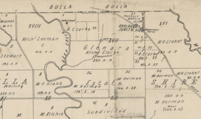
1897 PHOTOS OF "NYORA", SIR J. MADDEN'S "YAMALA" AND JAMES GRICE'S "MOONDAH" BETWEEN FRANKSTON AND MORNINGTON, VIC., AUST.
This article was found in an attempt to discover the ownership of Nyora between John Thomas Smith's death in 1879 and Henry Slaney's ownership of the property from about 1905 to 1922. At least two articles (including this one) insinuate that James Liddle Purves was this owner, while heritage citations/ studies claim that Purves was the owner of Nyora or a frequent guest at either Nyora or the Ranelagh guest house- can't remember which!)
PICTURESQUE PORT PHILLIP.
The Australasian (Melbourne, Vic. : 1864 - 1946) Saturday 27 February 1897 p 27 Article Illustrated
... NYORA, RESIDENCE OF MR. J. L. PERVES. PICTURESQUE PORT PHILLIP. Frankston is on the eastern shore ... deep blue sea. Mr. J. L. Purves lives some dis tance further on at Nyora, in a long roomy comfortable .
THE LINK:
PICTURESQUE PORT PHILLIP
Hopefully the Ranelagh Club has a photo of the Nyora homestead on display, but the history boards near the headless J.T.Smith memorial on J.T.Smith Reserve do not include a photo or mention when or if the homestead was demolished. Some red bricks from the homestead are inserted into the memorial.
From my journal about the origins of Mt Eliza street/place names within the Mornington Peninsula Shire and the parish of Moorooduc.
The truth of the matter is that J.L.Purves had only leased Nyora.
PROPERTY SALE.-The well-known property, "Nyora," containing 286 acres, situated on the Mornington road, at the junction of the Frankston and Hastings and Mornington shires, formerly leased by Mr J. L. Purves, has changed hands. The purchaser is Mr Henry Slaney, of the Haymarket, Melbourne. (P.2, Mornington Standard, 15-10-1904.)
Henry Slaney's executors must have sold Nyora to John Thompson.
Nyora Estate, Mount Eliza, has been sold. It is proposed to put down bowling greens, tennis courts and golf, links* on the estate. (P.15, The Age, 21-8-1923.)
* The golf links were built on the site of the Peninsula School.
RE SIR JOHN MADDEN.
It was probably from John Gilbert Mann's 1926 history of Mt Eliza that I found that Sir John Madden had married the daughter of Frank Stephen.
EventMarriage Event registration number2457 Registration year1872
Personal information
Family nameMADDEN Given namesJohn SexMale Spouse's family nameSTEPHEN Spouse's given namesGertrude Frances
Lady Madden died in 1925.
EventDeath Event registration number10354 Registration year1925
Personal information
Family nameMADDEN Given namesGertrude Frances SexFemale Father's nameSTEPHEN Frank Sydney Mother's nameFanny (Morgan) Place of birth Place of deathMELBOURNE EAST Age72
RE THE GRICE FAMILY'S BUSINESS INTERESTS. (From my T.J.Sumner journal.)
SUMNER.
The Victorian Government website on members of Parliament gives the following details about Theodotus John Sumner. He was born at Liskeard, Cornwall in 1920 and died on 20-4-1884 at Brunswick. His father was the Rev, John Sumner, a Methodist minister.
T.J.Sumner married Sarah Jones Peers. He was a merchant and his religion was listed as Methodist. Sumner emigrated to Van Diemans Land in 1841 and arrived in Melbourne in April 1842. He engaged in pastoral and agricultural pursuits and became a partner of Richard Grice in 1855 when Grice's former partner had died. Grice, Sumner and Co. were wholesale merchants who gave advances on pastoral properties. Theodotus was an early president of the National Agricultural Society and established a model farm on his Schnapper Point Estate. He became a member of the Board of Education in 1862 and was a member of the Legislative Council from May 1873 until February 1883.
Engaged in extensive charity work, T.J. endowed the Sumner ward at Melbourne?s Children?s Hospital. His widow administered his estate, a large part of which was in trust for charity, especially the Old Colonists' Home and the Melbourne Hospital.
A quick search on google revealed the following. Grice and Sumner had two ships built at Newcasle-on-Tyne in 1863: the Penola and S.S.Blackbird. The former was built especially for the Adelaide-Melbourne run but collided with, and sank, the City of Launceston in Port Phillip Bay on 19-11-1865. The damaged Penola was briefly replaced on the Adelaide run by the Blackbird which then worked the Brisbane mail run until 1873, undercutting passenger fares charged by the established lines. The Penola was sold to J.J.Grice and Partners and S.S.Blackbird was sold to Captain A.Campbell and Partners in 1876. (Flotilla-Australia website.)
An advertisement of Allotment 1 Moorooduc of 285.2.34 (the Ranelagh Estate at Mt Eliza) on which is erected Nyora (built by J.T.Smith and later Ranelagh Guest House) mentions that Mrs Sumner owned the adjoining Earimil. (Argus 7-11-1903.)
THIS JOURNAL WAS WRITTEN BEFORE I REALISED THE FOLLY OF NOT SUPPLYING PAGE NUMBERS!
BACK TO NYORA.
WEDNESDAY, NOVEMBER 25.
At the Rooms, 359 and 3G1 Collins-street.
At Half-past Two.
CHARMING SEASIDE RESIDENCE,
"NYORA,"
FRANKSTON; . ^
LAND, 283 ACRES 2 ROODS 34 PERCHES.
GEMMELL, TUCKETT, and Co. have received
instructions from THE TRUSTEES, EXECU-
TORS, AND AGENCY COMPANY LIMITED, to
SELL by PUBLIC AUCTION, at their rooms, as
above,
All that piece of land, being Crown Portion 1,
parish of Moorooduc, county of Mornington,
containing 285 acres 2 roods 34 perches,
fenced and subdivided, having FRONTAGES
to the PORT PHILLIP BAY and the MAIN
HOAD TO MORNINGTON, on which
erected the BRICK VILLA RESIDENCE
known as "NYORA,"
containing drawing, dining, and breakfast,
rooms (with folding, doors), six bedrooms,.
kitchen, servant's room, bathloom, pantries,
&c.: man's cottage, stabling, coachhouse,
poultry yards, vegetable and fruit garden,
&c.
This property is well situated, overlooking the
sea, and adjoins Earimil, the residence of Mrs.
Sumner, and is adjacent to Moondah, the residence
of James Grice, Esq., and the residence of James
Patterson, Esq., and others. (P.2, Argus, 21-11-1903.)
NYORA was not mentioned in this 1879 sale of the late John Thomas Smith's property. Sadly the executors are not named.
VALUABLE FREEHOLD PROPERTIES.
IN the SUPREME COURT of the COLONY of VIC
TORIA: Probate Jurisdiction -ln the Will of the
Honourable JOHN THOMAS SMITH, late of the City
of Melbourne, in the Colony of Victoria, Member of
the Legislative Assembly, Deceased -Notice is hereby
given, that after the expiration of fourteen days from
Ihe publication of this notice application will be made
to this honourable Court for PROBATE of the WILL
of the abovenamed John Thomas Smith, deceased to
be granted to Mrs Ellen Smith, the widow, and John
Thomas Smith and Sidney Smith, sons of the said
deceased, the executrix and executors named in and
appointed by the said will.
Dated this fourth day of February, 1879.
(P.3, Argus,5-2-1879.)
Having found no sale advertisements for Nyora in the 1880's (or "Portion 1 Moorooduc"), I dropped the inverted commas in the latter search and discovered that the Ranelagh Estate might never have happened! It was to be divided into blocks of between 5 and 20 acres. Portion 19 Moorooduc was called the Tower Paddock. I hadn't noticed that J.T.Smith senior was a grantee in the parish of Lyndhurst.
LYNDHURST AND MOOROODUC
Google LYNDHURST, COUNTY OF MORNINGTON to see John Thomas Smith's Lyndhurst grants. The southern boundary with the parish of Frankston was Seaford/Ballarto Rd (except on Long Island where Frankston went north to include today's Riviera Hotel site) and if you follow the road east you will find a fork (Melway 133 B9)that is now Cranbourne-Frankston Rd, Pearcedale Rd and the east boundary of Settlers Run Golf Course. East of the fork is c/a 13, granted to Hugh Glass, Smith's near neighbour at Flemington. Smith's c/a 14 was bounded by the proposed Ballarto Rd, Westernport Highway and (unsurprisingly!) HALL* RD., with c/a 15 to the north, extending north to a western extension of Duff St to the highway and east to the west end of Duff St. Part of the Ranfurlie Golf Course was on c/a 14.
(*Hall was leasing these grants.)
CHANGES OF PLANS FOR "NYORA".
The 1882 plans for blocks of between 5 and 20 acres went down like a lead balloon so the next tactic was selling the property as a whole, with plan B of three blocks all fronting the bay, in 1883.
ONE LOT OR THREE IN 1883, near end of last column.
By 1886, the plan had been changed to two blocks, one of 145 acres fronting the bay and the other, of 135 fronting the Schnapper Point road.
item 7, column 2, 1886
1902 WAS NOT A GOOD YEAR FOR MARY ANN BOND, NEE CUTHBERT, OF GLENARTHUR, GREENVALE, VICTORIA, AUSTRALIA.
Google YUROKE, COUNTY OF BOURKE to get the Yuroke parish map.
The land east of Section Rd, Greenvale, allotment C of section 2 parish of Yuroke, was granted to Leonard James and George Wolfenden Muchell (sic, Machell) in 1843. This was subdivided and sold to Messrs Lavars, Bond, Salisbury, Johnson, Davidson, and in 1854, John Lawrence bought lots 6 and 7. Part of lot 6 became the church site in Providence Lane. (Greenvale: Links with the Past by Annette Davis found in the Bulla file at the Sam Merrifield Library, Moonee Ponds.)
Leonard James Machell and George Wolfenden Machell sold portions of their grant, allotment C of section 2, parish of Yuroke to:
Her Majesty the Queen (Volume L folio 692)*, James Simpson (N 340), Thomas Dutton (U 120), William Bond (no reference to volume etc in index), John Johnson (U 382), S.Davidson (U 689), John Salisbury (U 691), John Lawrence (Z 510) and John Lavars (13 404). (1st series index vol.11 folio 204)
This would have been in about 1850 when the Governor proclaimed a road from the village of Broadmeadows to the northern boundary of the parish of Yuroke. There was no Mickleham Rd at that stage, just a line showing the boundary between 2C and 2D, so land would have had to be purchased from landowners.
According to John's death notice, William Bond arrived in about 1852 when his son John was about 8 years old BUT THIS SEEMS TO BE WRONG. (SEE JOHN'S 1888 BIOGRAPHY BELOW.) William may have purchased his land on PROVIDENCE PLAINS soon afterwards. However it was probably not the huge northern part of c/a 2C occupied by Bonds Lane. This would have been a subdivisional road and much of the northern part (ABOUT 200 ACRES- SEE MORE TITLES INFORMATION BELOW) was purchased by John Lavars who built the Greenvale Hotel at the north west corner of the crown allotment. John later sold much of his purchase, possibly to William Bond.
In 1863, William Bond was leasing a farm from James Pearson and was also assessed on a house and land with a net annual value of 18 pounds, which almost certainly he owned and was on c/a 2C. By 1879-80, (Page B77, DICTIONARY HISTORY OF TULLAMARINE AND MILES AROUND.)
When John married in 1869, his father's address was given as Providence Place and as Sam Mansfield owned the 40 acres between Swain St and this lane*, he would have been on the north side of Providence Place, perhaps through to Bonds Lane.
* VOLUME 143 FOLIO 996.
On 14-10-1864, Samuel Mansfield (related through later Johnson & Hickox weddings) bought lots 1,2 and 3 of the Machells’ subdivision from John Johnson for 250 pounds. This was almost certainly the farm (N.A.V.18 pounds) on which John Johnston was assessed in 1863. Lot 1 consisted of 13 acres 1 rood and 8 perches. Lots 2 and 3 each consisted of 13 acres and 2 roods. The western boundary of lot 3, which was at the south west corner of allotment C, adjoined allotment B (the eastern half of the former timber reserve).
Lots 1-3, described as 40 acres and owned by Sam Mansfield and later Harry Swaine, were bounded by the line of Swain St, a southerly extension of Section Rd, Providence Rd and Mickleham Rd. ( Melway reference 178, H/11.)
MARRIAGE
BOND—CUTHBERT - On tho 20th instant, at the bridegroom's residence, Providence-place, BroadmeadowS, by the Rev. M. Clarke, John Bond, son of Mr W. Bond,farmer, Euroke, to Mary Ann Cuthbert, daughter of Mr D. Cuthbert, Providence place. (P.2, The Age, 22-1-1869.)
JOHN'S 1888 BIOGRAPHY.*
BOND, John, Broadmeadows, is a native of Huntingdonshire, England who came to the colony with his parents in 1848, then being five years of age. He lived with his father for six months in Melbourne and for two years at Boroondara**; the followed the mining and carrying trades for some years, and afterwards took to farming with his father on the farm he now occupies at Broadmeadows, leased from Mr John Kerr Snr. He has 370 acres, principally under hay.He has bred some very good draught horses, and is at present breeding pure Ayrshire stock.
He has been married about eighteen years and has a family of five sons and three daughters living. His parents are still living on their freehold of 2000 acres at Yarrawonga***.
*Those who had their biographies published had to pay 6 pounds 6 shillings for a copy of the volume in which they were included but this was not made clear to them. John Bond and Robert Shankland had not agreed to pay. The canvassers got them to sign their provided biographies (answering questions without mentioning siblings!) and their signatures were probably copied onto an order form.
VICTORIA AND ITS METROPOLIS. FURTHER ACTIONS AGAINST SUBSCRIBERS.
** The Port Phillip directory of 1847 lists John Bond as a settler at the River Plenty. The Plenty River feeds into the Yarra within the parish of Bulleen about two miles north of the parish of Boroondara but perhaps the area near the junction of the two rivers was known as Boroondara in the 1840's or River Plenty was as imprecise a locator as Moonee Ponds was in those early days. This John Bond may have been William Bond's brother and the reason that William spent two years at Booroondara.
***Bundalong, which is 13 min (13.4 km) east of Yarrawonga on the Murray Valley Highway.
SOME MORE TITLES INFORMATION.
The following comes from correspondence with Keith Brown of Canberra, whose request for information about Gellibrand Cottage was referred to me by the Broadmeadows Historical Society. Luckily I'd saved my titles research information onto a word file. John Bond would have known those mentioned in bold type well. His mother in law's death notice reveals that one of her daughters became Mrs Papworth. John's brother, David, married a Lavars girl. (See David's obituary link below.)
U 120.
On 27-1-1853, Thomas Dutton paid 67 pounds 10 shillings for lot 5, which was on the northern side of Providence Rd (to which it had a 13 chain frontage starting 14 chains from the eastern boundary of Allotment C- this included the one chain width of Mickleham Rd.). The western boundary of 10 chains separated it from lot 4. William Bond was to have access along the un-named Providence and Section Roads. I have a feeling that Dutton actually acted as an agent for William Bond as Dutton’s index pages (from 4 302) do not mention him selling this land.
U 689.
On 4-2-1853, Samuel John Davidson paid 74 pounds 5 shillings for what seems to have been lot 4. Consisting of 13 acres 2 roods, it was bounded on the west by the government (timber) reserve, on the north by land bought by Lawrence (see Z 510) and on the east by Dutton’s (lot 5). In my haste, I traced later owners thinking I was dealing with the supposed Gellibrand Cottage site. Davidson sold to James Hooper (Y 529) who then sold it in two portions to Thomas Mallows (95 955) and Henry Papworth (195 573). Mallows also seems to have bought land from John Lawrence and sold the site(on lot 6) of the Wesleyan Church, which opened in 1869. This seems to have been belatedly memorialised on folios 559 and 560 of volume 814. Mallows also sold land to Enoch Hughes (296 774) and James Musgrove (327 72). Hughes sold his land to James Haberfield who sold it to Paul Clegg.
13 404.
On 7-6-1854, John Lavars paid 2400 pounds for what seems to have been 200 acres, based on lot 7 (64 acres- 13. 5 = 50.5) being about a quarter of its north-south extent and hence its size. His boundary commenced at the north west corner of allotment C “being the centre of the Deep Creek and Sydney road”. Its boundaries measured:
36. 90 (north), 54. 50 chains (east and west) and 39.11 chains (south).
I believe that Lavars purchased lots 8, 9, 10 and 11, each with a Mickleham Rd frontage of 13.6 chains, making up the 200 acres that Annette Davis claims he owned (Greenvale:Links with the Past).
WHICH OF JAMES PEARSON'S 370 ACRE GRANTS WAS OWNED BY JAMES PEARSON IN 1963 AND JOHN KERR SENIOR IN 1888?
WHEATLANDS ESTATE.
Near Broadmeadows.
The Propertv of Mr Jno. Kerr, Glenroy.
FARMS to be LET by TENDER, for Seven Years, from the 1st February, 1887.
NORTH SPRINGFIELD. 183 a. 3r. 6 p., occupied by Mr. Robert Trotman.
SOUTH SPRINGFIELD, 181 a. 3 r. 12 p., .occupied by Mr. Wm. Shankland.
FAIRFIELD., 185 a. 0 r. 25 p., occupied by Mr. John Bond.
MOUNT PLEASANT, 125 a. 1 r. 8 p., occupied by Mr. John Bond.
BROOKHILL, 183 a. 3 r. 14 p., occupied by Mr. M. Hoctor.
VALLEY FIELD, 177a. 1r. 3 p., occupied by Mr. M. Hoctor.
PROSPECT, 188 a. 1 r. 2 p. , occupied by Mr. M. Hoctor.
ROCKLAW, 192 a. 0 r. 13 p., occupied by Mr. Jas. Darmody.
(P.4, The Age, 1-4-1886, column 6 halfway down.)
Fairfield was 185 acres of crown allotment 3 E's 365 acres and Mount Pleasant's 125 acres probably accounted for 125 acres of the remainder, leaving about 60 acres of John's 370 acres in 1888 to identify. Valleyfield was never mentioned again and may have been broken up by Kerr's assignee by 1888 with John Bond buying the remainder of c/a 3E and perhaps another 5 acres in c/a 3F, also granted to Pearson, if John wasn't rounding off his acreage.
John and Mary Ann had moved directly north from Fairfield,sometime between October 1898 and 1900, across Somerton Rd to Glen Arthur, c/a 8N of the parish of Yuroke, which now lies beneath the western half of Greenvale Reservoir.
WHY WAS 1902 A BAD YEAR?
MARY ANN'S MOTHER.
CUTHBERT.-On the 31st March, at her son's residence, Greenvale, Hannah Cuthbert (relict of the late John Cuthbert), beloved mother of John and Charles Cuthbert, Mrs. George Papworth, Sale; Mrs. John Bond, Greenvale;
aged 75 years. "Safe in the arms of Jesus."
CUTHBERT.-The Friends of the late Mrs.HANNAH CUTHBERT are respectfully invited to follow the remains to the place of Interment in the Bulla Cemetery. The funeral will leave the residence of her son, Mr. Charles Cuthbert, Greenvale, to-morrow(Wednesday, 2nd inst.), at 1.30 o'clock p.m. (Both P.1, Argus, 1-4-1902.)
MARY ANN'S HUSBAND.
FATAL CART ACCIDENT.
SUNBURY, Sunday.
A fatal accident happened to Mr. John Bond, farmer, of Broadmeadows. While out driving he was thrown from his cart, and the horse and conveyance arriving home without him an immediate search was made. Mr. Bond was found on the road unconscious. He did not again become conscious, and died within about 24 hours. Deceased was 58 years of age, and had been a colonist for 50 years.(P.6, The Age, 1-12-1902.)
BOND.--On the 26th November (suddenly through accident) at his late residence, "Glen Arthur," Broadmeadows, John Bond, the dearly beloved husband of Mary Ann Bond and eldest son of the late William Bond, of Bundalong, aged 58 years. A colonist of 50 years.
BOND.—The Friends of the late Mr JOHN BOND are respectfully invited to follow his remains to the place of interment, in the Bulla Cemetery. The funeral will leave his late residence, "Glen Arthur," Broadmeadows, THIS DAY (Friday, 28th inst.), at 1 o'clock p.m. (Both P.1, Argus, 28-11-1902.)
The funeral of the late Mr. John Bond, of Greenvale, Broadmeadows (who was killed at his own gate by a buggy accident), took place on Monday afternoon, the remains being interred in the Bulla Cemetery. A large concourse attended, including Mr Gair, M L A, Councillor A Tait(of the City Council), and Mr John Grant(the veteran Ayrshire breeder) The Rev.H Richardson of the local Methodist Church conducted an impressive service at the house and grave. Mr. Bond was a colonist of 53 years' standing, and was widely known as a successful breeder of Ayrshire cattle and a popular judge at agricultural shows. (P.5, Argus, 2-12-1902.)
In 1909, Mary Ann had a clearing sale to wind up the estate.
WEDNESDAY, 10th NOVEMBER.
Twelve O'clock.
DISPERSAL SALE Of GLENARTHUR AYRSHIRE STUD, The Oldest* Founded Herd in Australasia.
ROBERT GUNN and Co. have received instructions from Mrs. John Bond, "Glenarthur," Greenvale, two miles from Somerton railway station, to SELL, as above,
The whole of the Glenarthur Ayrshire herd, of 110 head, comprising 15 males and 95. females, every one of which is for absolute sale, as Mrs. Bond intends winding up the estate. (etc.)(P.2, Argus, 3-11-1909.)
*Founded from McNab/Grant herd!
BOND. - On the 19th July, at the residence of her son-in-law (W. Blackler), Echuca#, Mary Ann, dearly beloved wife of the late John Bond, late of Broadmeadows, dearly beloved mother of Ernest, Florence*, Herbert** (deceased), Hurtle, Leigh, May, John and Cecilia, aged 82 years. Colonist of 74 years (Private interment.) At rest. (P.1, Argus, 21-7-1930.)
*John and Mary Ann's family obviously visited John's parents and siblings often enough for romance to blossom for Florence.
WILKINSON—BOND.—On the 12th September, 1899, at the residence of the bride's parents, by the Rev. William Harris, Walter George, eldest son of Charles Wilkinson, of Yarrawonga, to Alice Florence (Flo), eldest daughter of John Bond, Greenvale, Broadmeadows. (P.1, Argus, 12-10-1899.)
** INQUEST INTO HERBERT'S DEATH
Herbert was married and living in Broadmeadows township near what was called Munro's Corner*,which apparently was at the bottom right corner of Melway 6 C7.
*John Munro was in the township by 1880. He may have named "Milton Libourne" after a village and land parish in Wiltshire.
If this should meet the eye of JOHN ORR, or agent,who has land on Broadmeadows township, please send address to John Munro, Broadmeadows. (P.1, Argus, 5-3-1880.)
BOND.—On the 25th August, at his residence,"Milton Libourne," Broadmeadows (the result of an accident), Herbert Julius, the beloved husband of Maud Bond, and second eldest son of Mary Anne and the late John Bond, of Greenvale, and beloved brother of Ernest, Mrs. Wilkinson, Hurtle, Leigh, May, John, and Cecelia Bond, aged 34 years. Deeply regretted. The funeral, at Bulla, left from his house in Broadmeadows township.
(P.1, Argus, 26-8-1908.)
HERBERT'S WIDOW, MAUD.
BOND. - The Funeral of the late Mrs.MAUD BOND will leave 14 Ellesmere road, Windsor, THIS DAY, at 9 a.m. for the
Bulla Cemetery.(P.19, Argus, 22-9-1945.)
MAUD'S MAIDEN NAME WAS BENCE.
BENCE-On the 12th August (suddenly), at Bacchus Marsh John Bence brother of George,Fanny, Thomas, Mrs Cargill (deceased), James,Maud (Mrs. Bond) and Richard. (P.1, Argus, 14-8-1929.)
The Bence family had been running the Broadmeadows Hotel in 1898.
CYCLING. WHEEL NOTES. | A PLEASANT CIRCULAR RIDE.
The Australasian (Melbourne, Vic. : 1864 - 1946) Saturday 27 August 1898 p 22 Article
... the young crops are looking first-rate. We soon sped down a few steep slopes, and landed at Bence'e ... Broadmeadows Hotel one hour and a quarter after leaving the Melbourne Post-office, the cyclometer registering ...
# It looks as if somebody has misread the gravestone inscription or the Victorian BDM index re place of death. The latter has a bad habit of supplying just three letters for the place of death and ECA might have been written for ECHUCA. Neil has been informed about this being interpreted as East Carlton in his cemetery records below, and replied, just 58 minutes later:
Thanks for this - I have corrected my master file and will update the web shortly.
Neil Mansfield.
THANKS TO NEIL HAMILTON MANSFIELD'S BURIAL RECORDS AT BULLA CEMETERY!
149 BOND Albert Leigh 79Y 00/00/1879 00/10/1959 28/10/1959 Meth. 4 10 Son of John Bond & Mary Ann Cuthbert. Born and died in Greenvale, Victoria, Australia.
150 BOND Aubery Fuller 12Y7M 00/00/1915 00/10/1927 04/10/1927 Meth. 3 5 Son of Charles Hurtle Bond & Eileen Lenore Russell. Born in Ascot Vale, died in Melbourne East, Victoria, Australia.
151 BOND Charles Hurtle 85Y 00/00/1876 00/06/1961 27/06/1961 Meth. 4 11 Son of John Bond & Mary Ann Cuthbert. Born in Greenvale, died in Parkville, Victoria, Australia.
152 BOND Herbert Julius* 34Y 00/00/1874 00/08/1908 27/08/1908 C of E 2 6 Son of John Bond & Mary Ann Cuthbert. Died in Melbourne East, Victoria, Australia.
153 BOND John 58Y 00/00/1844 26/11/1902 28/11/1902 Meth. 2 5 Son of William Bond & Susannah Horton. Died in Broadmeadows, Victoria, Australia.
155 BOND (nee CUTHBERT) Mary Ann 82Y 00/00/1848 19/07/1930 21/07/1930 Meth. 2 5 Daughter of John Cuthbert & Hannah Cooper. Died in East Carlton#, Victoria, Australia.
457 CUTHBERT Charles 62Y 00/00/1856 10/03/1918 11/03/1918 Meth. 1 11 Son of John Cuthbert & Hannah Cooper. Died in Broadmeadows, Victoria, Australia.
458 CUTHBERT John 63Y 00/06/1825 00/06/1888 07/06/1888 Meth. 1 5 Son of William Cuthbert & Susan Unknown. Died in Ascot Vale, Victoria, Australia.
459 CUTHBERT John 73Y 00/00/1851 00/11/1924 22/11/1924 Meth. 1 13 Son of John Cuthbert & Hannah Cooper. Died in Sunshine, Victoria, Australia.
460 CUTHBERT William 4M 00/07/1888 00/12/1888 05/12/1888 Meth. 2 19 Son of William Cuthbert & Sarah Ann Cooper. Born and died in Ascot Vale, Victoria, Australia.
461 CUTHBERT (nee COOPER) Hannah 75Y 00/00/1827 00/04/1902 02/04/1902 Meth. 1 5 Daughter of Samuel Cooper & Unknown. Died in Broadmeadows, Victoria, Australia.
462 CUTHBERT (nee COOPER) Sarah Ann 24Y 00/08/1864 00/08/1888 11/08/1888 Meth. 2 19 Daughter of Samuel Cooper & Susan Moore. Born in Tullamarine, died in Ascot Vale, Victoria, Australia.
On page B78 of DHOTAMA, I had listed six BOND burials at Will Will Rook Cemetery. The Friends of the Will Will Rook Cemetery, who are launching the second edition of their cemetery records on 18-6-2018 at the Hume Global Learning Centre Library, have added information about 8 burials in the 1st edition, of October 2014.
324 William Bond buried 17-7-1874 aged 84 was born to unknown parents in England and was a Primitive Methodist. As John's parents were still alive in 1888, he may have been John's grandfather.
644 Sydney Clive Bond, buried on 17-2-1897 died at the age of 3 months, possibly while his parents Ernest Bond and Sarah Jane were visiting "Fairfield". Ernest was involved at Bundalong and competed in the inter-colonial ploughing competitions at Werribee on a regular basis.
Werribee Champion Ploughing Match.
Weekly Times (Melbourne, Vic. : 1869 - 1954) Saturday 4 August 1894 p 13 Article
... Prize at the Intercolonial Champion Ploughing Match, held at Werribee, in 1S83 ; Ernesc Bond, Bundalong ... . Heard, Highton. ' 1, David Bond, Bundalong (Garde and Chrystal) ;
722 Elizabeth Bond the 18 year old daughter of Elizabeth Bond of Glenroy, was buried on 3-1-1903.
John and Mary Ann were the parents of the following:
339 Annie, buried 8-5-1875. age 1 day;
364 John Albert, buried 17-4-1876, age 2 years 4 months, Primitive Methodist;
441 William Bond, buried 8-3-1882, age 12 days;
480 Lily Alexander, buried 22-4-1884, aged 1 month.
No Reg No. Nellie (Ellen) Bond, buried 8-3-1883, was stillborn and her birth record could not be found. She could have been the second of three tragedies for Mary Ann in 1882, 1883 and 1884.
It is no wonder that John Bond mentioned "five sons and three daughters living" in his 1888 biography.
OBITUARY OF JOHN BOND'S BROTHER, DAVID
David apparently married John Lavars' daughter.
JOHN BOND'S MOTHER.
BOND.-On the 11th ult, at Glen Horton, Peechelba*, Susanna, the dearly beloved wife of Wm. Bond of Peechelba, and mother of J. Bond, Broadmeadows, aged 76 years. A colonist of 48 years.(P.1, Argus, 29-1-1896.)
*PEECHELBA is 19 min (25.0 km) via Murray Valley Hwy/B400 and Wangaratta-Yarrawonga Rd/C374 from BUNDALONG.
1954 MORNINGTON PENINSULA SOUVENIR (1), VIC., AUST. (Pages 17-20.)
I couldn't remember the name of the timber business that operated on lot 1 of the Hindhope Estate on the west corner of Pt Nepean Rd and First Avenue at Rosebud. But I knew exactly where I could find out. The answer is on page 24 of the souvenir and although not painted green in 1954, the building looks much the same now as when H.and J.Hancock were running their timber and hardware store.
An Argus Souvenir of THE PENINSULA ARGUS FREE PHOTOS
The Argus (Melbourne, Vic. : 1848 - 1957) Thursday 7 January 1954 p 17 Article Illustrated
As I scrolled through the pages, I realised that a summary of the contents, including advertisements, might be of value to family historians and local historians, who might not be directed to the souvenir on trove when they enter the surname being researched. The digitisation of "bronzed Peter Logan" which I pasted below,illustrates why trove will produce NO RESULTS when there could actually be many.Photos will not be mentioned unless they include named people or buildings.
ADV.=Advertisements ART.=Articles.
Page 17.
ADV. Colortone Brick Ltd., Cranbourne Rd, Frankston. Peninsula Bus Lines Ltd.
ART. Happy memories of the bay with photos of camper surname signs at Rosebud, Diane Mahoney and Judith
Murray at Rosebud, and Maureen O'Sullivan and bronted Pater Logan at Mt Martha. (Maureen's companion was "bronzed Peter Logan"!)
Page 18.
ADV. Warner & Robertson, 66 Main St, Mornington (Real Estate). Rowley Bros, Rye and Flinders (Butchers.)
Penders Newsagency, Main St Mornington. F.Woodcock, watchmaker and jeweller, Nepean Hwy, Rye.
Patersons(electrical), 563-7 Bay St, Frankston, with pictures of fridge and washing machine models.
The Rye Pharmacy, S.S.Goble, between pier and post office, with Southern Peninsula Bookshop in the Pharmacy.
(Pauline Powell of the Rye Historical Society has written a detailed history of this shop and its proprietors.)
George E.Davies &Co. Real Estate, Nepean Hwy (next P.O.) Rosebud.
Rye Fruit Supply, S.& E.Gillies, Nepean Hwy, Rye. Wine at Ritchie's of Frankston.
ART. YACHTING. Need for safe anchorages-Frankston (Kananook)Creek the best but mouth silts up-clubs at Frankston (Fletcher, Steele, McConville), Mornington (Hall, Willey, Berry, Moorhead, Burriss), and Sorrento (Mrs E.Brabin).
Page 19.
ADV. E.H.Goss, builder, Sorrento and pictures of some of his buildings including Delgany and a Frankston church.
ART. Photos of Fletcher's yacht and scenes at Mornington pier with captions re fishing etc.
Page 20.
ADV. Sorrento Building Supply, Bowen Rd (no proprietors named.) Point Hardware and Joinery, 51 Main St, Mornington with picture of store (Prop. names possibly on sign.)
Powell motor body repairs, Phone Frankston 1709.
Hanton's Pharmacy of Frankston.
Bill Freeman's Saturday dances at The Phillip Ballroom, Pt Nepean Highway, Rosebud West.* ( This was on the site of the new service station on the west corner of Truemans Rd. It was later used as a roller skating rink. An excellent article about the ballroom and its proprietors appeared in the Rye Historical Society newsletter. It might have been the only ballroom on the peninsula at the time but Reg? Henderson operated a ballroom at some time in the Henderson Real Estate building on the west corner of Murray Anderson Rd at Rosebud.)
Norm Wood, shoe retailer, 104 Main St, Mornington. Mornington Ice and Cordial Works, 12 Garden St.
Harmsworth Stores (McCrae P.O., newsagency, drapery, hardware).
NU Peninsula Dry Cleaners, 111 Main St, Mornington.
Frankston Blind Co (manufacturers and retailers), 580 Bay St.
ART.
Come fishing (photo of Cynthia Bliss)with details and secrets about fishing. Old Ted McComb (photo), veteran fisherman who had rescued over 30 people on the bay, told of his rescues which involved Constable Stephenson, Gregory, Burton, Middleton, Grice.)
* RE "THE PHILLIP". The ballroom was not right on the Truemans Rd corner. The following, written by Dick Rowley who moved into 1839 Pt Nepean Rd, west of the ballroom,in 1955, was published in the July-September 2011 issue of the Rye Historical Society newsletter.
In 1946 John Ditchburn built a shop and residence for H.G.D.Maxwell at 1807 Point Nepean Road on the corner of Truemans Road, Tootgarook. The Maxwell family Gwynn and Blanche and children, Jeff, Merlin and Janice lived behind in the residence. The shop proved to be a success from the start with the locals, passing trade and campers. The shop was extended three times over the years. In 1951 the family moved and started a caravan park in Woyna Avenue. (Just across Truemans Rd.)
From 1951 to 1955 the Speakman family were the proprietors. Their daughter Jan worked in the shop and later married Chris Cairns. (No mention is made of who ran the store between 1955 and 1960.) The store was later run by Maurice and Shirley Joseph (1960-5)who had three children, and Merv and Shirley Drew (1865-73), whose children were Jeff, Janice, Annette, Jillian and Robyn. Later proprietors are detailed.
In 1960,a small shop was built between Max's Corner Store and the Phillip ballroom, and for two years it was operated as a cake shop by Mrs Garner and Mrs Foster.Keith and Gwen Found then ran it from 1963-5 as a fruit and vegetable shop, from there they moved to Rosebud where they opened Found's Furniture Shop.
Operating as a take-away food shop for the last ten years by Mark and Nina,it was demolished in 2010 revealing the Swallow's Biscuits and Medallion (lemonade)signs on the west wall of the original store.
I'm breaking this journal into parts to limit the number of surnames and prevent them disappearing from the surnames list. These are the surnames entered in the surname list:
MAHONEY,O'SULLIVAN,MURRAY,LOGAN,WARNER, ROBERTSON, ROWLEY,PENDER, WOODCOCK, PATERSON, GOBLE, POWELL, DAVIES, GILLIES, RITCHIE, FLETCHER, STEELE, McCONVILLE, HALL, WILLEY, BERRY, MOORHEAD, BURRISS, BRABIN, GOSS, HANTON,FREEMAN, HENDERSON,WOOD,HARMSWORTH, BLISS, McCOMB, STEPHENSON, GREGORY, BURTON,MIDDLETON,GRICE,
1954 MORNINGTON PENINSULA SOUVENIR (2), VIC., AUST. (PAGES 21-23.)
An Argus Souvenir of THE PENINSULA ARGUS FREE PHOTOS
The Argus (Melbourne, Vic. : 1848 - 1957) Thursday 7 January 1954 p 17 Article Illustrated
This continues on from the first journal that summarised details on pages 17-20.
ADV= Advertisements, ART= Article. Businesses will not be mentioned unless they include an address or name, except where extra detail can be supplied.
Page 21.
ADV.
Sorrento Hotel, W.B.Roseman. J.G.Taylor, canvas worker, 1 Main St, Mornington.
Rye Ice and Fuel Supply, Napier St, Rye. ( This was on the site of the R.S.L. car park. See Patricia Appleford's RYE PRIMARY SCHOOL 1667 which includes anecdotes from former pupils including a descendant of the supplies' owner.)
Rye Cake Kitchen, Nepean Hwy, next to jeweller.
Model Beach House at Mt Eliza(not involving locals.)
ART.
The Campers-Even the Kitchen sink.(Bert Deacon, Carlton F.C.great and his colony of 21 people from Preston; Mr.G.Armstrong, sec. of the Rosebud foreshore trust; Maslen, Riddell, Evans, Purcell,Spencer, Watkins, Stokes, Cairns, Walker, Charles, Sutherland.)
Page 22.
ADV. Johnston's Menswear of Mornington. Bayside Electrical Service, Nepean Hwy, Rosebud West.
Hilltop Estate, Hughes Rd, near Koonya Beach, Archer Real Estate.
F.E.Wood, Real Estate, opposite lighthouse, Nepean Hwy. ( Wood St, between Eighth and Ninth Avenue, Is named after Forrest Edmond (Joe) Wood, a Flinders Shire councillor, who was very active regarding the foreshore and the new hall at Rosebud,lived in the McCrae Homestead. He probably operated his business, which also involved a store, from one of the shops near the pedestrian lights.)
Max Searle, furniture maker, 9 Gordon St, Mornington.
Littleton Bros., General Store and Newsagent, Nepean Hwy, Dromana.
N.M.Bartley, chemist, Sorrento.
Lynwood Dairy, A.J.Parker and Son, 15 Vancouver St, Mornington. Possibly members of the pioneering Parker family of Parkdale. If I remember correctly, there was a big dairy in Lyndhurst that replaced many small dairies when pasteurisation became a requirement and Lynwood implies a connection.
ART.
Sage's Cottage has been in the news lately with the Menzies Foundation ending its connection as an economy measure. In 1954, the cottage, "Eurutta" was still occupied by Thomas Holden Sage 83, and his sister, Miss Ellen Amynta Sage 87, who had lived in the cottage for almost 80 years.Their uncle was surveyor, Robert Hoddle, and Benjamin Baxter, whose Carrup Carrup homestead was demolished in about 1951, was their grandfather. The article discusses the involvement in the infant settlement of Melbourne of Ben Baxter and his wife, and momentoes such as John Batman's rocking chair and Hoddle's survey chain. The photo of the pair is of poor quality.
Harry McComb,the 91 year old son of Frankston's founder, Thomas McComb, told how Thomas had been the mate on a windjammer that sailed to Tasmania in 1833 but deserted his ship and married Grace in 1844 before later being attracted to Victoria by the goldrush and settling at Frankston to work as a fisherman. Grace was the area's midwife and walked miles with her babe in arms to gather support for a government school.
John McComb of Carrum/Seaford, who was almost certainly a descendant of Thomas, was the last to farm Hindhope at Rosebud circa 1913 and it is a pity that McCombe St near Rosebud Plaza was given the wrong spelling in the subdivision plan.
Arthurs Seat-Superb View has an unclear photo of Dromana and surrounds and discusses the naming and history of the mountain and the panorama it provides.
Page 23.
ADV.
Redman's Timber and Hardware, Sorrento. The Oriental Hotel, Main St, Sorrento, R.J.&G.Popple.
Mornington Sports and Electrical, 110 Main St, Mornington.
Molyneux, frocks and hats by Arlene, Nepean Hwy, Rosebud,just near the hotel.
Arthur Moore, builder,78 Dandenong Rd, Frankston, established 1933.
Smith's Hardware, J.& V.Nettleton, Nepean Hwy, Rosebud.
G.S.Frean &Ride, timber and hardware, Barkly St, Mornington.
Mornington Peninsula Agricultural Society Annual Show 9-1-1954.
ART.
Sorrento's 1803 settlement. Mr.H.J.Leggett of "The Oaks", a fine old home near the settlement site, had spent 25 years since buying his property preserving the graves and collecting relics such as a 1793 cognac bottle and portions of the wooden casks that collected fresh water beneath the beach sand.The first birth,divine service, marriage, business, and burials in the (future)state involved the THORN,KNOPWOOD,HARVEY,GARRETT BLINKWORTH and SKILLMORE surnames.
William Buckley,the wild white man. Photo of Mrs Dennis (Leggett's grand daughter) of "The Oaks" holding spears that had come from Buckley's tribe. Contains a claim that Buckley was sleeping when discovered by the aborigines near Queenscliff. Without realising it, he was sleeping on the grave of an honoured chief, which in combination with his white skin, made the aborigines revere him.
To be continued in 1954 MORNINGTON PENINSULA SOUVENIR (3.)
ROSEMAN, TAYLOR, DEACON, ARMSTRONG, MASLEN, RIDDELL, EVANS, PURCELL, SPENCER, WATKINS,STOKES, CAIRNS, WALKER,CHARLES, SUTHERLAND, JOHNSTON, ARCHER, WOOD, SEARLE, LITTLETON, BARTLEY, PARKER, SAGE, HODDLE, BAXTER, McCOMB,REDMAN,POPPLE,MOORE, NETTLETON, FREAN, RIDE, LEGGETT,THORN,KNOPWOOD, HARVEY, GARRETT, BLINKWORTH, SKILLMORE, BUCKLEY,