OWR on Family Tree Circles
Journals and Posts
Childhood NOSTALGIA on Old Wellington Region
Remember? ~ Babies
and Toddlers
Remember? ~ Clothing
and Accessories, Grooming aids, Fashion etc
Remember? ~ Entertainment
movies, television, theatre, books
Remember? ~ Events
moments that took place
Remember? ~ Food & Drink
which are not seen so much today
Remember? ~ Health
Mum's remedies of old
Remember? ~ Home
objects we used or decorated with
Remember? ~ Objects
things not often seen now
Remember? ~ People
famous or infamous, those that inspired
Remember? ~ Play
the things we got up to / amused us as kids
Remember? ~ School
the things we did, the things we used
Remember? ~ Toys & Games
dolls, train sets, board games etc
Remember? ~ Vehicles
the wheels we used to get around on
Remember? ~ Work
the workplaces and tools of the trade
* also see MOST POPULAR Album
for some of the most popular Remember Posts
ALSO
ALL OUR ALBUMS in Alphabetical Order

UPPER HUTT Photo Albums on OWR
A condensed list of all the albums pertaining to Upper Hutt
on Old Wellington Region
Don't forget to look in Upper Hutt General
AKATARAWA
BROWN OWL
HERETAUNGA
Hutt FLOODS
Hutt RIVER
Hutt ROAD
Hutt VALLEY
KAITOKE
MAIDSTONE
MANGAROA
MAORIBANK
MAYMORN
MOONSHINE
SILVERSTREAM
TRENTHAM
Businesses & Industries
Churches
Civic Buildings
Dignitaries
GENERAL
Hotels
Main Street
Parks
Railways
Schools & Colleges
Services
Sports & Hobbies
WALLACEVILLE
WHITEMAN VALLEY
ALSO SEE List of all the albums in
ALPHABETICAL ORDER

PORIRUA & Suburbs Photo Albums
Porirua is one of the four cities that constitute the Wellington, New Zealand, metropolitan area; thus it is considered a part of Wellington as a whole. It is largely formed around the arms of the Porirua Harbour, the coastline facing out to Cook Strait and the north-eastern parts of the South Island. Most of the populated areas of Porirua are coastal: Camborne, Karehana Bay, Mana, Onepoto, Papakowhai, Paremata, Pauatahanui, Plimmerton, Pukerua Bay, Takapuwahia, Titahi Bay and Whitby all have direct access to coastal parks and recreation reserves. Several suburbs without direct coastal access, including Aotea, Ascot Park and Ranui Heights, have substantial portions with good views over the harbour. Elsdon, formerly known as Prosser Block, lost access to the harbour as a result of reclamation work, especially during the 1960s. Much of the existing city centre, north of Parumoana Street and east of Titahi Bay Road, was built upon this landfill.
* indicates district photo albums - go to links below
* indicates the suburb does not have its own album but photos of that area will be found in one of the other albums (usually in Porirua general)
The suburbs include the following
.. grouped by council ward ..
Eastern Ward
* Aotea - Only 10 people lived in the area in 1996. With new housing developments, the population increased to 120 in 2006 & 270 in 2018
* Ascot Park
* Cannons Creek
* Porirua East
* Ranui Heights
* Waitangirua - established in the 1960s
Northern Ward
* Camborne - developed from the 1960s
* Golden Gate – a local name for the eastern part of Paremata
* Hongoeka Bay – a Ngāti Toa settlement
* Judgeford – a rural locality
* Karehana Bay
* Mana - bounded by the entrance to Porirua Harbour and the
* Pauatahanui inlet of Porirua Harbour
* Paekakiriki Hill - for some of the best views in the district
* Papakowhai – where kowhai trees are prominent on headlands
* Paremata – name from the "Paremata Barracks", erected on the north shore of Porirua Harbour about 1846
* Pauatahanui - the road from Wellington reached Pauatahanui in Sep 1848
* Plimmerton – named for a director of the railway company
* Pukerua Bay – where film-maker Peter Jackson grew up
* Whitby – street names commemorate James Cook
Western Ward
* Elsdon – named after writer Elsdon Best
* Kenepuru – industrial area south-west of the centre, adjoining Linden
* Mana Island - predator-free, bird sanctuary island, off the coast of Porirua
* Onepoto - translates as "short beach"
* Porirua Central – Porirua's central business district
* Takapuwahia – a Ngāti Toa settlement
* Titahi Bay – where pro golfer Michael Campbell grew up
The Suburbs in Photo Albums
JUDGEFORD
photo Judgeford floods in 1959
MANA Island
.. includes Mana
photo Mana Esplanade 1964
PAEKAKARIKI Hill
.. includes Paekakariki in general
photo from Paekakariki Hill
PAREMATA
photo crossing Paremata bridge 1936
PAUATAHANUI
photo Pahautanui main street 1903
PLIMMERTON
photo winter in Plimmerton 2005
PORIRUA general
photo Cannons Creek 1966
PUKERUA Bay
photo building Centennial Highway, Pukerua Bay to Paekakariki 1939
TITAHI Bay
photo Titahi Bay beach 1930s
WHITBY
photo Whitby 2007
PHOTO
Speedboats on Porirua Harbour 1955

MASTERTON Photo Albums on OWR
Because of the size of the MASTERTON, Wairarapa photo album
on Old Wellington Region they have now been divided into more manageable albums
Masterton ~ Businesses & Industries, places of work
- also look in Queen Street album
Masterton ~ Churches, & Religious ceremonies, all denominations
Masterton ~ Civic Buildings, Banks, Post Offices, Town Halls, Libraries etc
Masterton ~ general
Masterton ~ Hood Aerodrome, fun & displays of gliders, planes etc
Masterton ~ Hotels, Accommodation, Taverns, Motels
Masterton ~ Maraes Whares, Farms, Homesteads etc
Masterton ~ Parks, Recreation / Sports Grounds / Showgrounds
Masterton ~ Queen Street, Main Street through town
Masterton ~ Railways, Stations, Trains
Masterton ~ Schools & Colleges, Convents
Masterton ~ Services, Ambulance, Fire, Hospital, Police
Masterton ~ Sports & Hobbies, except school sports
- look in Masterton Schools & Colleges for school sports
ALSO SEE other WAIRARAPA albums
CARTERTON, Wairarapa
CASTLEPOINT & RIVERSDALE, Wairarapa
FEATHERSTON, Wairarapa
GLADSTONE, Wairarapa
GREYTOWN, Wairarapa
LAKE FERRY, Wairarapa
MARTINBOROUGH, Wairarapa
MAURICEVILLE, Wairarapa
TAUHERENIKAU, Wairarapa
TINUI, Wairarapa
WAIRARAPA, general
PHOTO
Masterton is world famous for the GOLDEN SHEARS

Photos of UPPER HUTT on Old Wellington Region
OLD WELLINGTON REGION has thousands of old photos in albums. Unfortunately Facebook does not support listing them in alphabetical order. This has made finding the district you're looking for very difficult and time consuming.
... ALSO SEE ...
* HUTT FLOODS, also see other district albums
* HUTT RIVER, also see the district albums
* HUTT ROAD, anywhere along
* HUTT VALLEY, general
* Photos of LOWER HUTT on Old Wellington Region
* Photos of PETONE on Old Wellington Region
* list of ALL the ALBUMS in ALPHABETICAL ORDER
... Photos of UPPER HUTT ... on Old Wellington Region
Upper Hutt ~ Businesses & Industries, work places
Upper Hutt ~ Churches, & Religious ceremonies, all denominations
Upper Hutt ~ Civic Buildings, Banks, Post Offices, Town Halls, Libraries etc
Upper Hutt ~ Dignitaries, Mayors, Councillors etc
Upper Hutt ~ General
Upper Hutt ~ Hotels, Pubs, Taverns, Motels
Upper Hutt ~ Main Street, the main street through town
Upper Hutt ~ Parks, Recreation / Sports Grounds
Upper Hutt ~ Railways, Trains, Buses, Stations etc
Upper Hutt ~ Schools & Colleges, the buildings, children, teachers etc
Upper Hutt ~ Services, Fire, Ambulance, Police etc
Upper Hutt ~ Sports & Hobbies except School Sports events
- look in Upper Hutt School & Colleges for school sports
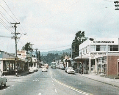
PHOTO
From Upper Hutt General Album
Photos of LOWER HUTT on Old Wellington Region
OLD WELLINGTON REGION has thousands of old photos in albums. Unfortunately Facebook does not support listing them in alphabetical order. This has made finding the district you're looking for very difficult and time consuming.
* Three years along and some of the albums have so many photos that loading, and looking for a particular photo, takes too long so we have divided some regions into the following categories ...
... ALSO SEE ...
* HUTT FLOODS, also see other district albums
* HUTT RIVER, also see the district albums
* HUTT ROAD, anywhere along
* HUTT VALLEY, general
* Photos of PETONE on Old Wellington Region
* Photos of UPPER HUTT on Old Wellington Region
* list of ALL the ALBUMS in ALPHABETICAL ORDER
... Photos of LOWER HUTT ... on Old Wellington Region
Lower Hutt ~ Businessess & Industries, work places
Lower Hutt ~ Churches, & Religious ceremonies, all denominations
Lower Hutt ~ Civic Buildings, Banks, Post Offices, Town Halls, Libraries etc
Lower Hutt ~ Dignitaries, Mayors, Councillors etc
Lower Hutt ~ General
Lower Hutt ~ High Street, Main road through town
Lower Hutt ~ Hotels, Pubs, Taverns, Motels
Lower Hutt ~ Parks, Recreation / Sports Grounds
Lower Hutt ~ Railways, Trains, Buses, Stations etc
Lower Hutt ~ Riddiford Park
Lower Hutt ~ Schools & Colleges, the buildings, children, teachers etc
Lower Hutt ~ Services, Fire, Ambulance, Police, Hospitals etc
Lower Hutt ~ Sports & Hobbies except School Sports events
- look in Lower Hutt School & Colleges for school sports
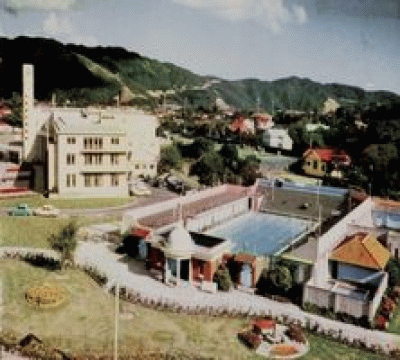
PHOTO
From the RIDDIFORD PARK Album
PETONE Albums on Old Wellington Region
PETONE (Māori: Pito-one), is a large suburb of Lower Hutt in the Wellington Region, NZ. It stands at the southern end of the Hutt Valley, on the northern shore of Wellington Harbour. The Māori name Pito-one means "end of the sand beach". The first Europeans settlers arrived on Petone Beach on the 'Aurora' 22 Jan 1840, making it one of the oldest settlements in the Wellington Region. It became a borough in 1888, merged with Lower Hutt and branded as "Hutt City" in 1989.
ALL THE ALBUMS for PETONE & surrounds in
Old Wellington Region
* Also see ..
Photos of * LOWER HUTT on Old Wellington Region
Photos of * UPPER HUTT on Old Wellington Region
All Photos in All Albums
* BEACH & along the Esplanade
* BUSINESSES & Industries
* CHURCHES
places of worship - all denominations
* CIVIC BUILDING
Banks, Post Offices, Town Halls, Libraries
* DIGNITARIES
Mayors, Councillors etc
* GEAR MEAT ~ also see Gear Meat photos in the Lambton Quay, Cuba & Taranaki Street albums
* HOTELS
Pubs, Taverns, Motels, Clubs
* HUTT FLOODS
* HUTT RIVER
also look in other nearby districts albums
* HUTT ROAD ~ above photo shows the forming of Hutt Road after the 8.2 earthquake, 23 Jan 1855
* HUTT general
possibly some Petone in here
* JACKSON Street
main street through town
* PARKS ~ Recreation/Sports Grounds
* PETONE General
* RAILWAYS
trains, stations, workshops & the workers
* SCHOOLS & Colleges
the children, teachers, buildings
* SERVICES
Fire, Ambulance, Police, Hospitals
* SPORTS & HOBBIES, except any School Sports events
look in Petone School & Colleges for school sports
PHOTO above
PETONE WHARF 2002 looking towards Wellington Harbour on a stormy day, with Matiu/Somes island in the background.
PHOTO below
JACKSON STREET main street through Petone, April 1930

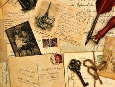
Lost New Zealand Photos
do you have New Zealand LOST or FOUND old photos that need identifying
Lost NZ Photos is a new branch of the Old Wellington Region community site
We all seem to find old photos in boxes in the attic or garage or in mum's/grandma's things. Sometimes even whole albums of ancestors we never knew. Some people find great photos in second hand shops. If you would like them identified you can upload them to the site linked here and hope for identification. This is a New Zealand site. Their readers may be able to help you identify them or can return the photos to the descendents/family they belong to if they can be found
THEY WRITE ...
The site is for anywhere in New Zealand. If you have any old family photos and would like help to identify them, or get them back to the family they are from, you are welcome to upload them with a short description of where & when to our new facebook page Lost NZ Photos
Photos of PETONE on Old Wellington Region
OLD WELLINGTON REGION has thousands of old photos in albums. Unfortunately Facebook does not support listing them in alphabetical order. This has made finding the district you're looking for very difficult and time consuming.
* Three years along and some of the albums have so many photos that loading, and looking for a particular photo, takes too long so we have divided some regions into the following categories ...
... ALSO SEE ...
* HUTT FLOODS, also see other district albums
* HUTT RIVER, also see the district albums
* HUTT ROAD, anywhere along
* HUTT VALLEY, general
* Photos of LOWER HUTT on Old Wellington Region
* Photos of UPPER HUTT on Old Wellington Region
* list of ALL the ALBUMS in ALPHABETICAL ORDER
... Photos of PETONE ... on Old Wellington Region
Petone ~ Beach, and along the Esplanade
Petone ~ Businesses & Industries, work places
Petone ~ Churches, all denominations
Petone ~ Civic Buildings, Banks, Post Offices, Town Halls, Libraries etc
Petone ~ Dignitaries, Mayors, Councillors etc
Petone ~ Gear Meat (also on Lambton Quay, Adelaide Rd, Cuba & Taranaki St)
Petone ~ General
Petone ~ Hotels, Pubs, Taverns, Motels
Petone ~ Jackson Street, the main street through town
Petone ~ Parks, Recreation / Sports Grounds
Petone ~ Railways, trains, stations, workshops & the workers
Petone ~ Schools & Colleges, the children, teachers, buildings etc
Petone ~ Services, Fire, Ambulance, Police, Hospitals etc
Petone ~ Sports & Hobbies, except School Sports events
- look in Petone School & Colleges for school sports
PHOTO
Wellington Woollen Manufacturing Company - 1940s
Photo in Businesses Album

Photos at OWR in ALPHABETICAL order
OLD WELLINGTON REGION now has thousands of old photos in albums. Unfortunately Facebook does not support listing them in alphabetical order. This has made finding the district you're looking for very difficult and time consuming.
Therefore, we have made this list as a supplement to assist you in your search
AIRPORT, the development 1950s
AKATARAWA, Upper Hutt
ALICETOWN, Lower Hutt
AOTEA QUAY, now including Customhouse, Jervois & Waterloo Quays
- now includes Cable Street
ARO VALLEY
ART WORK, paintings & drawings with connections to Wellington
ATHLETIC PARK, Berhampore
AVALON, Lower Hutt
BANKS & POST OFFICE, (Wellington) people and miscellaneous
BASIN RESERVE, Wellington
BEFORE & AFTER, an old & new look of the same area
BELMONT, Lower Hutt
BERHAMPORE, Wellington
BITS & PIECES
BOATS, SHIPS - watercraft
BOTANIC GARDENS, 101 Glenmore St, Kelburn
BOULCOTT Street
BOWEN Street
BROWN OWL, Upper Hutt
BROOKLYN, Wellington
BUCKLE Street, central Wellington
CABLE CAR, runs Lambton Quay to the Botanic Garden
CABLE Street, now in Jervois Quay Album
Cape TERAWHITI, southwestern-most point of the North Island
CAMBRIDGE & KENT Terraces
CARDS, old postcards, Xmas cards etc
CARTERTON, Wairarapa
* also see WAIRARAPA general album
CARILLON of bells, if looking for photos of the Carillon
- see the albums "Mount cook" or "Buckle Street"
CASTLEPOINT & RIVERSDALE, Wairarapa
* also see WAIRARAPA general album
COOK STRAIT & southern coastal areas
COURTENAY Place, City Centre
COVER PHOTOS taken from a prior post
CUBA Street, City Centre
CUSTOMHOUSE Quay, with Aotea, Jervois & Waterloo quays
- now includes Cable Street
DAIRY INDUSTRY, Wellington
DAYS DAY, Eastbourne
DIXON Street, Courtenay Place/Taranaki Streets to The Terrace
EARTHQUAKES, all Wellington regions
EASTBOURNE & BAYS, Lower Hutt
EPUNI, Lower Hutt
EVANS BAY, Wellington
FEATHERSTON, Wairarapa
* also see WAIRARAPA general album
FEATHERSTON STREET, Wellington
GLADSTONE, Wairarapa
* also see WAIRARAPA general album
GLENSIDE, Wellington
GOVERNMENT & PARLIAMENT, Buildings, House & Grounds
GRACEFIELD, Lower Hutt
GREYTOWN, Wairarapa
* also see WAIRARAPA general album
HANNAHS FIRE on Lambton Quay 8 July 1977
HATAITAI, Wellington
HELP PLEASE, readers needing help with a memory
HERETAUNGA, Upper Hutt
HOROKIWI, Hutt Valley
HOUGHTON BAY, Wellington
* HUTT FLOODS, also see other district albums
* HUTT RIVER, also see the district albums
* HUTT ROAD, anywhere along
* HUTT VALLEY, general
ISLAND BAY, Wellington
JERVOIS Quay, with Aotea, Customhouse & Waterloo quays
* now includes CABLE Street
JOHNSONVILLE, Wellington
JUDGEFORD, Porirua
.. also see all Porirua & Suburbs in one album
KAITOKE, Upper Hutt
KAIWHARAWHARA, Wellington
KAPITI COAST, general
KAPITI ISLAND, Kapiti Coast
KARAKA BAY, Wellington
KARORI, Wellington
KELBURN, Wellington
* also see CABLE CAR Album if looking in here for them
KENT & CAMBRIDGE Terraces
KILBIRNIE, Wellington
KHANDALLAH, Wellington
KOROKORO, Lower Hutt
LAKE FERRY, Wairarapa
LAMBTON QUAY, City Centre
also see Lambton Quay Fire at Hannahs 8 July 1977
* also see CABLE CAR Album if looking in here for them
Lower Hutt ~ Businessess & Industries, work places
Lower Hutt ~ Churches, & Religious ceremonies, all denominations
Lower Hutt ~ Civic Buildings, Banks, Post Offices, Town Halls, Libraries etc
Lower Hutt ~ Dignitaries, Mayors, Councillors etc
Lower Hutt ~ General
Lower Hutt ~ High Street, Main road through town
Lower Hutt ~ Hotels, Pubs, Taverns, Motels
Lower Hutt ~ Parks, Recreation / Sports Grounds
Lower Hutt ~ Railways, Trains, Buses, Stations etc
Lower Hutt ~ Riddiford Park
Lower Hutt ~ Schools & Colleges, the buildings, children, teachers etc
Lower Hutt ~ Services, Fire, Ambulance, Police, Hospitals etc
Lower Hutt ~ Sports & Hobbies except School Sports events
- look in Lower Hutt School & Colleges for school sports
LYALL BAY, Wellington
MAIDSTONE, Upper Hutt
MAKARA, Wellington
MANA, Porirua
- includes MANA ISLAND
.. also see all Porirua & Suburbs in one album
MANGAROA, Upper Hutt
MANNERS Street
MANOR PARK, Lower Hutt
MAORIBANK, Upper Hutt
* also see UPPER HUTT general
MARTINBOROUGH, Wairarapa
* also see WAIRARAPA general
Masterton ~ Businesses & Industries, places of work
- also look in Queen Street album
Masterton ~ Churches, & Religious ceremonies, all denominations
Masterton ~ Civic Buildings, Banks, Post Offices, Town Halls, Libraries etc
Masterton ~ general
Masterton ~ Hood Aerodrome, fun & displays of gliders, planes etc
Masterton ~ Hotels, Accommodation, Taverns, Motels
Masterton ~ Maraes Whares, Farms, Homesteads etc
Masterton ~ Parks, Recreation / Sports Grounds / Showgrounds
Masterton ~ Queen Street, Main Street through town
Masterton ~ Railways, Stations, Trains
Masterton ~ Schools & Colleges, Convents
Masterton ~ Services, Ambulance, Fire, Hospital, Police
Masterton ~ Sports & Hobbies, except school sports
- look in Masterton Schools & Colleges for school sports
* ALL WAIRARAPA ALBUMS in one link
MAUNGARAKI, Lower Hutt
MAURICEVILLE, Wairarapa
MAYMORN, Upper Hutt
MELROSE, Wellington
MERCER Street, Wellington central
MILESTONES on our page
MIRAMAR, Wellington
MOERA, Lower Hutt
MONDAY MYSTERY, readers try to guess untitled photos
MOONSHINE, Upper Hutt
* also see UPPER HUTT general album
MOST POPULAR postings
MOUNT COOK, Wellington
MOUNT HOLDSWORTH, Tararuas
MOUNT VICTORIA, Wellington
MUSEUMS, of the Wellington Region
NAENAE, Lower Hutt
NEWLANDS, Wellington
NEWTOWN, Wellington
NGAIO, Wellington
NGAURANGA, Wellington
NORTHLAND, Wellington
NORMANDALE, Lower Hutt
ORONGORONGO, Rimutaka area
ORIENTAL BAY, Wellington
OTAIHANGA, Kapiti Coast
OTAKI, Kapiti Coast
OUR PEOPLE, when photo location unknown
OUT OF TOWN, outside Wellington
OWHIRO BAY, Wellington
PAEKAKARIKI, Kapiti Coast
.. also see all Porirua & Suburbs in one album
PARAPARAUMU, Kapiti Coast
PAREMATA, Porirua
.. also see all Porirua & Suburbs in one album
PARLIAMENT & GOVERNMENT, Buildings, House & Grounds
PAUATAHANUI, Porirua
.. also see all Porirua & Suburbs in one album
PENCARROW LIGHTHOUSE Wellington
Petone ~ Beach, & along the Esplanade
Petone ~ Businesses & Industries, work places
Petone ~ Churches, all denominations
Petone ~ Civic Buildings, Banks, Post Offices, Town Halls, Libraries etc
Petone ~ Dignitaries, Mayors, Councillors etc
Petone ~ Gear Meat (also on Lambton Quay, Adelaide Rd, Cuba & Taranaki St)
Petone ~ General
Petone ~ Hotels, Pubs, Taverns, Motels
Petone ~ Jackson Street, the main street through town
Petone ~ Parks, Recreation / Sports Grounds
Petone ~ Railways, trains, stations, workshops & the workers
Petone ~ Schools & Colleges, the children, teachers, buildings etc
Petone ~ Services, Fire, Ambulance, Police, Hospitals etc
Petone ~ Sports & Hobbies, except School Sports events
- look in Petone School & Colleges for school sports
* ALL PETONE ALBUMS in one link
PHOTOS WANTED, readers requests
PLIMMERTON, Porirua
.. also see all Porirua & Suburbs in one album
POMARE, Lower Hutt
PORIRUA, general
.. also see all Porirua & Suburbs in one album
POST OFFICE & BANKS , (Wellington)
people and events miscellaneous (also see suburban branches)
PROFILE Pictures
PUKERUA BAY, Porirua
.. also see all Porirua & Suburbs in one album
the 4 QUAYS, Aotea, Customhouse, Jervois & Waterloo
- now includes Cable Street
QUAYS & WHARVES Wellington central
RAILWAY STATION, Wellington's Main Station
RAUMATI, Kapiti Coast
Remember? ~ Babies & Toddlers
Remember? ~ Clothing, & Accessories, Grooming aids
Remember? ~ Entertainment, movies, television, theatre, books
Remember? ~ Events, moments that took place
Remember? ~ Food & Drink, which are not seen so much today
Remember? ~ Health, the remedies of old
Remember? ~ Home, objects we used or decorated with
Remember? ~ Objects, things not often seen now
Remember? ~ People, famous or infamous, those that inspired
Remember? ~ Play, the things we got up to as kids
Remember? ~ School, the things we did, the things we used
Remember? ~ Toys & Games dolls, train sets, board games etc
Remember? ~ Vehicles, the wheels we had to get around on
Remember? ~ Work, tools of the trade
* also see MOST POPULAR Album for some Remember Posts
RIMUTAKAs
RONGOTAI AIRPORT, & other airports/aerodromes in Wellington region
- also see
developing the AIRPORT, 1950s
ROSENEATH
SEATOUN, Wellington
SEAVIEW, Lower Hutt
SHAPING Old Wellington Region, the pioneers who built the way we live
SILVERSTREAM, Upper Hutt
SOMES ISLAND, Wellington
SOUTHERN COASTAL areas including Cook Strait
SPECIAL DAYS, Father's Day, Mother's Day etc
STOKES VALLEY, Lower Hutt
STRATHMORE PARK, Miramar Peninsula
TAITA, Lower Hutt
TARANAKI Street, stretches 1.3km from the waterfront
TARARUA RANGES, runs NE-SW for 80km from Palmerston North to the upper reaches of the Hutt Valley, where the northern tip of the Rimutaka Range begins
TAUHERENIKAU, Wairarapa
TAWA, Wellington
TE ARO, Wellington
TE HORO, Kapiti Coast
THEATRES, movie, concert, etc
The TERRACE, from Abel Smith St to Bowen St
THORNDON, Wellington
* also see Tinakori Road/Hill album
THORNDON QUAY, with Pipitea Pa
TIMELINE photos, not yet in albums
TINAKORI Road & Hill
* also see Thorndon album
TINUI, Wairarapa
TITAHI BAY, Porirua
.. also see all Porirua & Suburbs in one album
TODAY in HISTORY, a look back to what shaped NZ
TOWN HALL, 109 Wakefield Street
TRAINS, all regions
- also see individual suburbs and Wellington Railway Station
TRAMS & BUSES, where exact location not known
TRENTHAM, Upper Hutt
UNIDENTIFIED old photos
Upper Hutt ~ Businesses & Industries, work places
Upper Hutt ~ Churches, & Religious ceremonies, all denominations
Upper Hutt ~ Civic Buildings, Banks, Post Offices, Town Halls, Libraries etc
Upper Hutt ~ Dignitaries, Mayors, Councillors etc
Upper Hutt ~ General
Upper Hutt ~ Hotels, Pubs, Taverns, Motels
Upper Hutt ~ Main Street, the main street through town
Upper Hutt ~ Parks, Recreation / Sports Grounds
Upper Hutt ~ Railways, Trains, Buses, Stations etc
Upper Hutt ~ Schools & Colleges, the buildings, children, teachers etc
Upper Hutt ~ Services, Fire, Ambulance, Police etc
Upper Hutt ~ Sports & Hobbies except School Sports events
- look in Upper Hutt School & Colleges for school sports
VICTORIA Street, from Hunter St to Webb St
VIVIAN Street, from end of motorway to Cambridge Tce (mostly one way since 2007)
WADESTOWN, Wellington
WAIKANAE, Kapiti Coast
WAINUIOMATA, Lower Hutt
WAIRARAPA, general
WAIWHETU, Lower Hutt
WAKEFIELD Street, Kent Tce to Victoria St
WALLACEVILLE, Upper Hutt
WATERLOO, Lower Hutt
WATERLOO Quay, with Aotea, Customhouse & Jervois quays
WELLINGTON, general
WELLINGTON AIRPORT, the development during 1950s
Wellington as it was 100 YEARS AGO this week
Wellington RAILWAY STATION, Wellington's Main Station
WHAT WAS THIS?, weird & wonderful objects
WHITBY, Porirua
.. also see all Porirua & Suburbs in one album
WHITEMAN VALLEY, Upper Hutt
WILLIS Street, City Centre
WILTON, Wellington
WINGATE, Lower Hutt
WOBURN, Lower Hutt
WORSER BAY, Wellington
Wellington ZOO, Newtown
PHOTO
taken from our posting HOLLOWAY Road Aro c1900s

- Displaying 1-10 of 10 Journals
- PAGE:
- 1
- of1