itellya on Family Tree Circles
Journals and Posts
W.W.1 ROLL OF HONOUR FOR QUEENSCLIFF DISTRICT, VIC., AUST. (Includes Drysdale, Marcus, Leopold, Moolap, Ocean Grove, Portarlington, and Wallington,)
Queenscliff Sentinel, Drysdale, Portarlington, Sorrento Advertiser (Vic. : 1914 - 1918) Sat 18 Mar 1916 Page 3 ROLL OF HONOR
QUEENSLAND DISTRICT ROLL OF HONOUR
Last night I was trying to read the names on a photo of the Shire of Nunawading Roll of Honour and it was a hopeless task. I had the same trouble last year trying to transcribe the names on the photo of the W.W.1 memorial seat at Flinders, Victoria so I decided to publish them in a journal, involving only a very pleasant drive from Rosebud. I'm sure that somebody is looking for these lists.
Unfortunately, I can't copy and paste the digitisation which just reads across columns, mixing up names from the various areas, so perhaps somebody is clever enough to take a screen shot of the actual page and attach it to a journal. There are too many names to fit into a surnames list.
I think Ocean Grove would have been struggling to field a footy team in those days!
If you google Marcus, Victoria, you'll get a map showing the locations of Marcus Hill and Wallington. The name Moolap comes from the aboriginal description of Point Henry. The area includes Point Henry and, extending south, straddles the Bellarine Highway. MAP OF MOOLAP
Leopold is east of Moolap and was originally known as Kensington before it was royally renamed.
MAP OF LEOPOLD
VALE'S 1909 SUBDIVISION PLAN OF CROWN ALLOTMENT 17 WANNAEUE BETWEEN JETTY RD AND NORM CLARK WALK, ROSEBUD, VIC., AUST.
VALE'S SUBDIVISION PLAN
THE ABOVE LINK IS PROVIDED IN A SEPARATE JOURNAL BECAUSE I CAN NEVER REMEMBER WHERE I HAVE INCLUDED PARTICULAR INFORMATION SUCH AS MAPS AND THIS PLAN.
From my journal A BRIEF HISTORY OF ROSEBUD, VICTORIA, AUSTRALIA.
CROWN ALLOTMENT 17.
This was a working farm in early days.
"129 acres superior agricultural land, having a large frontage to Hobson's Bay, and described in the Government plan as having water at a short distance from the surface , together with a neat cottage containing four rooms and a garden, fruit trees, fenced in. (P.2, Argus, 4-3-1857.)
By the second Kangerong Road Board assessment of 5-9-1865, "Woolcott" was assessed on 129 acres, Wannaeue. In 1879, Woolcote was assessed on squiggle acres! Despite such helpful detailed rate records, subsequent research indicates that the following was the SON OF THE man from whom George and Susan Peatey bought the 2 acre lot 76 of Woolcott's subdivision on the south corner of Jetty Rd and McDowell St in 1878, occupying it in 1888 when they had repaid Nelson Rudduck's loan. (PINE TREES AND BOX THORNS, Rosalind Peatey.)
EventDeath Event registration number2040 Registration year1904
Personal information
Family nameWOOLCOTT Given namesRichd Robt SexUnknown Father's nameWoolcott Wm Mother's nameElizth Ann Way (Spark) Place of birth Place of deathMvern Age68
At the height of the land boom when Jack Jones' store across Jetty Rd was probably still the only store on the inland side of the beach road west of Peatey's Creek, Woolcott made a determined effort to dispose of the many unsold blocks on his estate. Louis Anderson may have bought lot 41 at that time on which he ran Rosebud's first proper post office 1891-7.
"ROSEBUD BAY
That picturesque neighbourhood a little to the south of Dromana on the main road to Sorrento. The remaining unsold lots in the estate of R.R. Woolcott Esq, being part of portion 17 parish of Wannaeue each lot having an
area of 1 1/4 acre and upwards. A new Jetty, state school, and other Improvements have recently been added to the attractions of this place, which must ultimately become one of the most popular of our suburban watering
places." (P.2, Argus, 27-1-1888.)
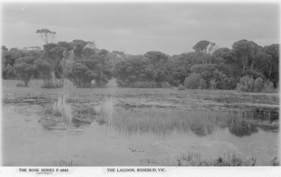
He may have had more success if he'd promoted a Gumbuyah Park type of water-play park where children could row boats on the Rosebud Lagoon* without them getting out of their depth or being swept out through the heads!
(* Photo of the lagoon, which was drained in about 1950, is attached to the brief history journal.)
In 1910, "Vale", agent, Melbourne was assessed on 84+ 84 acres 17 Wannaeue. Something wrong there as c/a 17 only consisted of 129 acres. The other 84 acres may have been in the Clacton on Sea estate. In 34 years or so, Woolcott had only sold about 45 acres! W.F.Vale had divided the 84 acres remaining into 300 lots.
Extracts from the huge advertisement on P.21, Argus, 9-1-1909.
"ROSEBUD,NEAR DROMANA. 300 SEASIDE LOTS AT TWO POUNDS EACH.
IN SAME ESTATE AS THE ROSEBUD POST-OFFICE AND SCHOOL.
ONLY 10/ DEPOSIT EACH LOT.
BALANCE 5/ MONTHLY, WITHOUT INTEREST.
No reservation as to taking adjoining blocks. Adjoining part of Clacton-on-Sea, but being portion of the block closer to Dromana. 50ft. frontages.----- NOTE the nearness of our Lots to Post Office,Jetty, Beach, Mechanics' Institute, and the homes of the residents of the Township. Take a walk along Foreshore, and notice the particularly safe sandy Beach, beautiful clear water, perfect bathing, and play-ground for children.---- CALL AT ONCE FOR PLAN AT W. F. VALE & CO.,"
CHARLES SHUTER, POLICE MAGISTRATE (VIC., AUST.) AND HIS SHORT-LIVED SON, THE DOCTOR.
CHARLES SHUTER WAS A PROMINENT PIONEER OF MOONEE PONDS.
He didn't get a mention in THE STOPOVER THAT STAYED but Lenore Frost wrote about him in her STREET NAMES OF ESSENDON. He was a police magistrate and covered a huge area. Shuter St, between Puckle St and Gladstone St in Moonee Ponds was named after him but so was a street in Greendale, a small town between the western Highway and Blackwood. He was a grantee in the parish of Blackwood which extended almost to Ballan. I was surprised to read this in Margot Hitchcock's history column in the BLACKWOOD TIMES*.
" Still another victim, who,though not born on Blackwood, could almost be claimed as a native, as I believe he was born at his father’s residence near Greendale. I refer to Dr. Shuter, son of the well-known & respected Police Magistrate, Mr. C.Shuter, who died at his father’s residence Malvern, on Easter Monday. I have heard that the young Dr. was a man of great promise, & his death is deeply lamented by a wide circle of friends. The young man, I think, had only attained the age of about 30 years when he died. "
(Bacchus Marsh Express - Sat April 12, 1890)
EventDeath Event registration number8093 Registration year1890
Personal information
Family nameSHUTER Given namesChas Yalden SexMale Father's nameChas Mother's nameAmelia Elizth (Lord) Place of birth Place of deathMvern Age30
The birth was apparently registered at Collingwood but this may have been because there was no registrar yet at Ballan, or maybe because Amelia's mother lived there.
EventBirth Event registration number5715 Registration year1860
Personal information
Family nameSHUTER Given namesCharles Yalden SexUnknown Father's nameCharles Mother's nameAmelia Eliza (Lord) Place of birthCOLL
The birth DID take place at Collingwood.
On the 6th inst., at Victoria-parade, the wife of Charles Shuter, Esq., police magistrate, Ballan, of a
son.(P.4, Argus, 8-3-1860.)
It seems unlikely that Amelia's parents were living at Collingwood.
On the 10th inst., at Trinity Church, Bacchus Marsh, by the Rev. J. T. Schleicher, Charles Shuter, Esq., Police Magistrate, to Amelia Elizabeth, second daughter of John Lord, Esq., late of Sydney. (P.4, Argus, 14-8-1858.)
BUT John Lord was a labourer of Collingwood when he applied for discharge of his insolvency in 1849.
(The Argus (Melbourne, Vic. : 1848 - 1957) Tuesday 15 May 1849 p 3 Article)
Charles Shuter's house at Moonee Ponds was called Newstead. The Puckles bought a fair piece of Peter McCracken's "Ardmillan Estate" west of the railway and if I remember correctly the bridegroom's Sydenham Villa was demolished for the construction of the Ardmillan House Reception Centre near the top of Ardmillan Rd. Charles certainly mixed with many prominent families judging by the guests at the wedding.
PUCKLE-SHUTER WEDDING
* THE BLACKWOOD TIMES
EMAIL FROM MARGOT HITCHCOCK.
---. from my unpublished book ‘The History and Pioneers of Blackwood.” I have evidence Charles Shuter was in Blackwood in the 1850’s….– one as early as 1855. 32 references in all..!!! two as copied here.
Thanks
Margot
“Assistant Commissioner Standish reports - Mr. Robert McKenzie was appointment the first Warden of the Mt. Blackwood Goldfield in 1855 and he together with a Magistrate and a Police Officer who had already been on the field for several months represent the law of the time. Robert McKenzie the first Warden was transferred to a larger field in 1856. In June 1855 the Warden was sharing the Police Officer's tent along with the Stipendiary Magistrate. The tent was also used as a Police Court, Wardens' Office and Mess Room. Tenders were put in and soon substantial buildings were erected up to replace the tent. Warden McKenzie was later replaced by Warden Charles Shuter. ”
Also - Saturday 25 June 1859. MOUNT BLACKWOOD - From our Correspondent.
“FATAL MINING ACCIDENT- One of those catastrophes that too often arise from the careless or venturesome manner in which miners conduct their operations, occurred at Kangaroo Flat on Tuesday last, 18th instant, whereby James Brown (generally known as Kentucky) lost his life. Brown was endeavouring to remove a single pillar that supported a large mass of earth; this he was doing cautiously, but without propping or slabbing; when suddenly the superincumbent mass fell
crushing and burying him beneath. He was immediately dug-out and conveyed to his tent, was perfectly sensible, and it was thought he would recover, but early the following morning he died.
An inquiry was held on Friday before Charles Shuter, Esq, J.P and an examination made by Dr. Kieser of Ballan, from whose evidence it was ascertained that death was cause by rupture of the bladder, occasioned by the earth falling on him.”
THOMAS PATRICK DURACK, HEADTEACHER AT DROMANA STATE SCHOOL, VIC., AUST., FOR ALMOST 4 YEARS PRIOR TO JANUARY 1911.
THOMAS PATRICK DURACK, HEADTEACHER AT DROMANA STATE SCHOOL FOR ALMOST FOUR YEARS AND HEAVILY INVOLVED IN COMMUNITY ACTIVITIES.
I am often asked to recommend a history which will contain information about a certain pioneer and in many cases, ESPECIALLY THOSE OF TEACHERS, there isn't one. T.P.Durack is not mentioned in A DREAMTIME OF DROMANA so he therefore is included under my 1988 bicentennial pledge to acknowledge pioneers who have escaped the attention of municipal or local historians.
(To access the articles, copy the bold type and paste it into your search bar.)
THE DURACK FAREWELL IN JANUARY 1911.
https://trove.nla.gov.au/newspaper/article/70088392
I couldn't find the birth record of the child born during their time in Dromana because I'd searched from 1907 to 1910, not expecting the birth to have taken place so soon before their departure. Luckily the birth was mentioned by the child herself soon after her 10th birthday in 1921.
DOREEN'S LETTER.
https://trove.nla.gov.au/newspaper/article/171057393
DOREEN'S BIRTH RECORD.
EventBirth Event registration number2787 Registration year1911
Personal information
Family nameDURACK Given namesDoreen Julia SexFemale Father's nameThos Patk Mother's nameAnnie Agnes (Bourke) Place of birthDROMANA
A BRIEF HISTORY OF ROSEBUD, VICTORIA, AUSTRALIA.
A BRIEF HISTORY OF ROSEBUD.
(Type WANNAEUE, COUNTY OF MORNINGTON into your search bar to see the parish map.
To see the map of the Rosebud/ Boneo area in 1855, copy Part of the Parish of Wannaeue near the Village Reserve of Dromana ... into your search bar.)
FOREWORD.
Apart from a brief bit about Rosebud's name, I've put the cart before the horse and dealt first with the area inland of the beach road now known as Rosebud (and a tad beyond) to get across the message that this area was either working farms (with a bit of lime quarrying from Boneo Rd to the west) or vacant land lost through mortgages that became wasteland suitable only for grazing whose occupancy can not be determined because properties were not described properly. By the time TERRY E.W. was elected to council in 1910, the Shire of Flinders and Kangerong was almost bankrupt and he tried to have properties described accurately so that changes of ownership (usually to financial institutions because of unpaid mortgages)could be tracked and rate notices sent out. His colleagues would not support him so he resigned in protest. It was not until about 1914 that rate collectors started trying to describe all properties. Much of the wasteland in Wannaeue and Fingal, south of Limestone Road, was bought for a song from the financial institutions by James Little Brown who soaked up some wonderful stories told by Robert Rowley, such as NO GOOD DAMPER
Some working farms' homesteads in today's Rosebud, that could indicate that the original Rosebud was the fishing village, have been demolished. REMAINING are John Cain's "Midway" just south of Bunnings. Wahgunyah, atop Menstry's Hill in Mitchell St, Eastbourne in William Crescent in Rosebud West, Woyna House in Terry St, and Eleanora* in the Rosebud Hospital grounds. (Apart from the Wong-Shing Market between Johnson St and Eastbourne Rd, the only agriculture recorded on David Cairn's property is Bob Parr's statement that the 3-4 acre Eleanora grounds had a big orchard at the back. P.168, STORIES OF ROSEBUD WEST.)
DEMOLISHED with the blessing of council are:
Hindhope Villa, 50 First Avenue. History is our story and boy there are some great stories about this house but they'd lose their flavour if told in front of the massive apartments for which this 110+ year old house was demolished in 2017.
Jack Raper's Wannaeue Estate homestead on the east side of the Driveway into Olympic Park from Eastbourne Rd which Bart Rogers occupied when he managed the pine plantation where we now see the freeway extension and the northern part of the Rosebud Country Club. This was about the same age as Hindhope Village and was demolished in about 2010.
I've decided to leave the fishing village to last because I need to refute the Wikipedia entry about THE ROSEBUD which claims that the Rosebud's life did not end near Rosebud (Mt Martha and Mt Eliza being mentioned as its location!) and supply details about some of the fishermen and use of Rosebud regarding location BEFORE the Rosebud Fishing Village was alienated. (1870 re wannaeue village, 1867 hurricane-jack and elizabeth jones, bucher,1869 boxing match tragedy, registration of bucher births, fred vine by 1866, william johnston, Miss Hazledine's 1897 letter about the picnic at Cape Schanck etc.)
THE NAME.
It has been said that Rosebud was originally known as Banksia Point but when the schooner, Rosebud, was stranded in 1855, the location of the wreck was given as “between the White Cliff and Arthur's Seat, near the Heads, in May last.”(P.6, Argus, 29-11-1855.)
The coast between these two POINTS is a gradual curve, there is no mention of Banksia Point as an official name and any early fishermen would have referred to the coastal banksias as Honeysuckles.
The Rosebud had been owned by Edward Hobson but had been purchased by James Purves in about March 1855 and insured with 12 brokers for a total of 700 pounds.
THE PARISH.
Rosebud is within the parish of Wannaeue which included parts of three squatting runs: Arthurs Seat, Tootgarook and Boniyong.
Edward William Hobson originally occupied land on the north side of Arthurs Seat in 1837, calling it Canjeerung but in 1838 sent the Desailley boys to build some huts on the other side of the mountain. In 1841, Jamieson’s Special Survey, four square miles of the parish of Kangerong, had been sold by the Crown and by 1843 the Arthurs Seat Run was made available and taken up by Andrew McCrae.
Hobson is believed to have moved to the Tootgarook run before the Survey was purchased but only remained until 1843 when he and Maurice Meyrick of Boniyong moved to Gippsland, being replaced as lessees by George Smith (partner of Hobson’s mother) and John Barker, respectively. Smith left for California in about 1849, taking a young Boon-wurrung lad, Johnnie, with him. Before leaving, Smith transferred the coastal part of Tootgarook near McCrae to the Arthurs Seat run and the rest to Hobson who then transferred the lease to James Purves whose brother Peter ran Tootgarook Station until his death in 1860. Smith obviously returned because Johnnie died in 1851 and was buried by George McCrae near the lighthouse site not long before the Arthurs Seat Run was transferred to the Burrells.
The parish of Wannaeue extended east to Mornington-Flinders Rd near the Red Hill Consolidated School, south to Limestone Rd and west to Weeroona St Rye but the following information pertains only to the part of the parish between Anthony’s Nose and Truemans Rd, south to Browns Rd.
ARTHURS SEAT PRE-EMPTIVE RIGHT.
The Arthurs Seat Run was poor grazing country and the Burrells were looking to sell it before long. They probably made as much money from timber as they did from cattle. The pre-emptive right was bought in two parts. The part of crown allotment 1, section B, Wannaeue between the Cape Schanck Road and the foreshore was retained by the Burrells and the related Coburn family of “Springbank” with the Bartels and Cornell families also being early residents of what became known as Dromana West until CONFUSION OF NAMES caused the area to be named McCrae.
Crown allotment 2 section B south of the junction of The Avenue and Cape Schanck Rd, was leased or sold to such as George Burston of Fitzroy who was the occupant of 368 acres of the P.R. by 1919.
The Burrell wing of the McCrae Homestead has much information about the Burrells and their relatives, including John Twycross, grantee of c/a 12, Rosebud Fishing Village, whose beautiful watercolour paintings and pioneering photography can be inspected. It is because of an environmentally conscious member of the Burrell family that the McCrae section of the foreshore remains so beautiful today.
Section 20, WANNAEUE VILLAGE.
Apart from its poor grazing capacity, Georgiana’s McCrae’s fear that her homestead block would be swallowed by the proposed Dromana Township with a two mile frontage to the Bay was responsible for Andrew’s decision to sell the lease to the Burrells. The 185 chain (3.7 km) frontage between McCulloch St, Dromana and The Avenue, McCrae, did not interfere with the homestead block and included the P.R. between Dromana Township and the Wannaeue Village Reserve.
As the Government wanted to ensure demand for township blocks exceeded supply, in order to get the best price possible for them, they decided to reserve the Wannaeue Village site where the water was too shallow for a pier, until the demand became apparent, and so that it earned money for the Government coffers until such time, they apparently leased the village site to Captain Henry Everest Adams.
In much the same way that the story about Rosebud being originally called Banksia Point originated, Captain Adams’ lease became a 750 acre grant in the family folklore (as well as his being the illegitimate son of Lord Vivian and marrying Miss May in England!)
Wannaeue Village, between The Avenue and the line of Parkmore Rd, was not alienated until the 1870’s, with the Adams family snapping up all the land on the west side of Wattle Rd (now Wattle Place),being the grounds of Hopetoun House, and all the land between South Rd and the Cape Schanck Road.
CROWN ALLOTMENT 19, NO SECTION.
This 191 acre allotment was withdrawn after it had been included in an advertisement of crown land available for selection.(P. 6,The Age, 22-9-1855.) Nothing has been discovered about the grantee, Isaac White, except for an indenture between Captain Adams and Isaac concerning a property in the parish of South Melbourne in which Isaac expressed his affection for the Captain's wife. I believe that because he was already leasing the Wannaeue Village reserve, he would not have been allowed to select c/a 19 and Isaac did so acting as a dummy for him. By the first assessment in 1864, Henry Everest Adams was rated on the property, extending his occupancy east to the line of Adams Avenue. it was used for the Vivyan Vinyard and orchards. The Captain was retiring in 1877 after 20 years residency in the area and was selling properties near the Arthurs Seat summit as well as c/a 19 Wannaeue. The comfortable house was near Wattle Rd on c/a 20; the frontage of c/a 19 was only 32 chains or 640 metres so the stated frontage of nearly half a mile included the frontage east of Parkmore Rd to Wattle Rd.
"That valuable farm, containing 191 acres, subdivided into seven paddocks, partly laid down in English grasses, substantially fenced with post, rail, and wire, and having a bay frontage of nearly half a mile ; orchard*, garden, and vine-yard containing 2000 vines all in full bearing, with a comfortable weatherboard house containing 10 rooms, outhouses, &c..; brick tank holding 4000 gallons. Crops to be removed or taken
at a valuation." (P.3, Argus, 10-3-1877.)
* 600 fruit trees as specified by Henry's widow, Eliza, in 1881.(P.4, The Age, 15-12-1881.)
Such farming requires good drainage and the 191 acre property was flooded during the HOBSON FLAT DRAINAGE dispute of 1904, causing much animosity between Back Road Bob Cairns and Robert Henry Adams.
(P.5, Mornington Standard, 6-8-1904.)
CROWN ALLOTMENT 18.
Granted to G.H.Warren, this land of 152.6 acres was between the line of Adams Avenue and Jetty Rd, backing onto the government (Eastbourne) road east to its junction with the Cape Schanck road. Warren still owned the land in 1865 and had apparently leased the 152 acres to a Mr Parr in 1864. It was later sold to Charles Blakey, poundkeeper of Somerton, some time before 1871 when Blakey had sold lot 86, 2 acres on its north west corner to Jack Jones who was obviously a local fisherman and bought crown allotment 6 of the Rosebud Fishing Village on 16-8-1872.
Blakey had died by 1874 when his executors advertised the sale of land at Broadford and Wannaeue, noting that lot 86 (as revealed in a memorial in Harvey Marshall's scrapbook recording a loan that Captain Henry Everest Adams had given to William Edwards) had been sold. Blakey had made no improvements to the land and obviously the grantee hadn't either.
"Lot 2.-Portion l8, parish of Wannaeue, county of Mornington, containing 152a. 2r. 16p. No improvements.
Both these properties are moderately timbered. The Broadford land is on Sunday-creek, near the township and railway station. The Wannaeue land fronts the bay, and is sold subject to a piece 60 x 330, fronting the beach-road, being taken out of it, having been previously sold." (P.3, Argus, 18-2-1874.)
In 1875, Robert White (1804-1881), grantee of c/a 11 Rosebud Fishing Village in 1873, was assessed on the land. The only child of Henry White and Margaret, nee Cairns, he was the father of Henry Bucher's wife Ann. It has been noted that Ann was from Clackmannan, Scotland as were the Cairns brothers of Boneo. Robert came out on the John Linn in 1859, nearly a decade after the death of his wife, with his three surviving children, Janet b.1839, Ann B. 1842 and Robert b.1849. They may have gone straight to Little Scotland at Boneo where he was recorded as renting a hut from the Cairns brothers in the first assessment, of 1864. On 26-7-1877, Robert Junior married Margaret Hillis and in the same year he took over the ownership of the 150 acre farm. On 25-4-1881, his father died, his place of death in Rosebud given as Menstry Hill after the small Scottish village (near Clackmannan) where he was born. (All details from PIONEERS OF THE PENINSULA by Stephen Lynch.)
On 4-7-1888 Robert Jnr's wife Margaret, suffering from melancholia, was committed to the Kew Asylum where she died before the end of the year and Robert sold the property in September, moving to the 27 acre "Glenferrie" on the north corner of White Hill and McIlroys Rds at Red Hill where Robert acquired the nickname of Blooming Bob White to distinguish him from his sister Janet's son Robert. Here his children could be cared for by Hadassah Hillis who married Blooming Bob in 1899. Robert had forgotten to mention lot 86 when he sold the 150 acre farm to the Lake Brothers in September and in 1889, the buyers tried unsuccessfully to evict Jack Jones (who had built a store on the FJ's site in about 1884-5.)
LAKE V JONES.
LAW REPORT. SUPREME COURT. EQUITY COURT. FRIDAY, SEPT. 13. (Before His Honour Mr. Justice A'Beckett.) LAKE V. JONES.
The Argus (Melbourne, Vic. : 1848 - 1957) Wednesday 18 September 1889 p 11 Article
The sale fell through and the 150 acre farm was owned by woolclasser Thomas Bamford and then the Pottons. The rest of the story of this farm can be read in the HENRY POTTON'S FARM chapter of Peter Wilson's ON THE ROAD TO ROSEBUD. De Garis, who bought the farm to subdivide it as the Heart of Rosebud Estate, lived at 19 Mitchell St (located on a sudden rise which probably made Robert White senior think of Menstry Hill for a name) which he called Wahgunyah. De Garis committed suicide twice!
CROWN ALLOTMENT 17.
This was a working farm in early days.
"129 acres superior agricultural land, having a large frontage to Hobson's Bay, and described in the Government plan as having water at a short distance from the surface , together with a neat cottage containing four rooms and a garden, fruit trees, fenced in. (P.2, Argus, 4-3-1857.)
By the second Kangerong Road Board assessment of 5-9-1865, "Woolcott" was assessed on 129 acres, Wannaeue. In 1879, Woolcote was assessed on squiggle acres! Despite such helpful detailed rate records, subsequent research indicates that the following was the man from whom George and Susan Peatey bought the 2 acre lot 76 of Woolcott's subdivision on the south corner of Jetty Rd and McDowell St in 1878, occupying it in 1888 when they had repaid Nelson Rudduck's loan. (PINE TREES AND BOX THORNS, Rosalind Peatey.)
EventDeath Event registration number2040 Registration year1904
Personal information
Family nameWOOLCOTT Given namesRichd Robt SexUnknown Father's nameWoolcott Wm Mother's nameElizth Ann Way (Spark) Place of birth Place of deathMvern Age68
At the height of the land boom when Jack Jones' store across Jetty Rd was probably still the only store on the inland side of the beach road west of Peatey's Creek, Woolcott made a determined effort to dispose of the many unsold blocks on his estate. Louis Anderson may have bought lot 41 at that time on which he ran Rosebud's first proper post office 1891-7.
"ROSEBUD BAY
That picturesque neighbourhood a little to the south of Dromana on the main road to Sorrento. The remaining unsold lots in the estate of R.R. Woolcott Esq, being part of portion 17 parish of Wannaeue each lot having an
area of 1 1/4 acre and upwards. A new Jetty, state school, and other Improvements have recently been added to the attractions of this place, which must ultimately become one of the most popular of our suburban watering
places." (P.2, Argus, 27-1-1888.)
He may have had more success if he'd promoted a Gumbuyah Park type of water-play park where children could row boats on the Rosebud Lagoon without them getting out of their depth or being swept out through the heads!
In 1910, "Vale", agent, Melbourne was assessed on 84+ 84 acres 17 Wannaeue. Something wrong there as c/a 17 only consisted of 129 acres. The other 84 acres may have been in the Clacton on Sea estate. In 34 years or so, Woolcott had only sold about 45 acres! W.F.Vale had divided the 84 acres remaining into 300 lots.
Extracts from the huge advertisement on P.21, Argus, 9-1-1909.
"ROSEBUD,NEAR DROMANA. 300 SEASIDE LOTS AT TWO POUNDS EACH.
IN SAME ESTATE AS THE ROSEBUD POST-OFFICE AND SCHOOL.
ONLY 10/ DEPOSIT EACH LOT.
BALANCE 5/ MONTHLY, WITHOUT INTEREST.
No reservation as to taking adjoining blocks. Adjoining part of Clacton-on-Sea, but being portion of the block closer to Dromana. 50ft. frontages.----- NOTE the nearness of our Lots to Post Office,Jetty, Beach, Mechanics' Institute, and the homes of the residents of the Township. Take a walk along Foreshore, and notice the particularly safe sandy Beach, beautiful clear water, perfect bathing, and play-ground for children.---- CALL AT ONCE FOR PLAN AT W. F. VALE & CO.,"
CROWN ALLOTMENTS 16 AND 15.
By 1864, Hugh Glass owned 231 acres without encumbrance according to the Kangerong Road District’s first assessment. This land could only have consisted of his grant, c/a 14, and c/a 16 of 115 acres granted to H. Stratford and J. Ridgway in mid 1856. The beach road frontage of c/a 16 was 2040 links which confirms my conclusion made in 2010 based only on its acreage. Most likely the grantees were speculators and had become insolvent. It was probably at this auction in 1859 that Hugh Glass had bought c/a 16 from the mortgagees.
“All that piece or parcel of land, in the colony of Victoria, containing by admeasurement 115 Acres, be the same more or less, situated in the County of Mornington, Parish of Wannaeue, Portion 16,” The northern boundary was 20 chains 40 links (405 metres), 2040 links as stated on the parish map and the southern boundary (on today’s Eastbourne Rd) was 18 chains 90 links or 1890 links as on the parish map. (P.2, Argus, 24-10-1859, column 5, item 6.)
By 1871, Glass had become insolvent because of scab in his numerous flocks and the huge expense of building the palatial Flemington House west of Kent St Ascot Vale. His grant, c/a 14, was split up into lots of 29, 29, 20, 20 and 16 acres and because properties were never described properly in rate records until about 1914, c/a’s 16 and 15 as well as one 29 acre lot that became part of Hindhope would have been owned by financial institutions who occasionally managed to find a tenant, such as Ned Williams who in one year was assessed on 1500 acres, Wannaeue.
No doubt the promoters of the Clacton-on-Sea Estate in 1909 had picked up c/a’s 15 and 16 dirt cheap and despite their prizes for jingles on the radio and lucky steamer tickets the subdivision was not a raging success; in fact there was much criticism. Many buyers forfeited their blocks due to unpaid rates and the southern part of the estate was virtually a ti tree tangle until the Shire acted in the 1980’s as described in PETER Wilson’s ON THE ROAD TO ROSEBUD.
CROWN ALLOTMENT 14.
Consisting of 116 acres 3 roods 38 perches (116.9875 acres)and bounded by the Beach road, First Avenue, Eastbourne Rd and Boneo Rd, this was granted to Hugh Glass who became insolvent as discussed under c/a 16. Crown allotment 14 was divided into northern portions of 29 acres,one of which became Randall's HINDHOPE, the other having been forfeited to an investment company, being added to Hindhope by Eleanor Rigg on 4-9-1909; the southern half was divided into portion of 20, 20 and 16 acres which were eventually consolidated by Ramsey and Nora Couper, to form a farm called The Thicket. Their daughter married a son of William Jamieson, grantee of crown allotment 14 Rosebud fishing village not long before the Coupers moved to Box Hill and were replaced by Alf Rawlings. Alf, who died in 1922 aged 81, was the last owner of The Thicket which Keith McGregor leased for a year or two while he established a motor passenger service in about 1920 before Keith and his brother moved to the Stawell area to take up wheat growing. Keith sold the licence for his passenger service to his brother in law Billy Adams, a descendant of Captain Adams.
Hindhope was bought on 23-10-1914 by developer Arthur Alfred Thomas who had instructed his surveyor to name the northern boundary of section A after John McComb a Carrum/Seaford farmer who was the last man to farm Hindhope but he labelled it McCombe St. At least he got the spelling of Thomas St right! A huge portion of Hindhope, 14 acres including the Rosebud Plaza site was purchased by Alexander Mackie Younger's first wife, an expert riflewoman who managed to shoot herself just after doing so, according to the only witness, her husband!
The subdivision of The Thicket commenced in 1927, the Rosebud Park Estate being praised for its innovative curved streets such as Warranilla Avenue. Both farms were certainly working farms.
CROWN ALLOTMENT 13.
This 128 acres included a 5 acre block at what became known as Martin's Corner and was bounded by Eastbourne, Boneo and Point Nepean roads, extending west almost to the Chinaman's Creek drain. Edward Hobson established a kiln there when he moved from Kangerong and it might have been the one on the corner of Braidwood Rd and Whitehead Grove mentioned by the late Bob Parr. Limeburning seems to have continued on the property until David and William Cairns sons of Alex Cairns and Janet , nee DALGLEISH, bought the property from the MARKS estate in 1906. Mal Cairns discovered a buried limeburner's crowbar when he and other shire workers were making Mirriam Avenue. David Cairns built and later donated, Eleanora, the heritage-listed house within the hospital grounds.The Wong market garden, which gave Chinamans Creek its name, eventually extended the length of Johnson St, named after the man who subdivided it as the BEACH GARDEN ESTATE.
See much more detail in Bettyanne Foster's STORIES OF ROSEBUD WEST.
CROWN ALLOTMENT 53, THE WOODTHORPE ESTATE.
This was granted to William Allison Blair but little detail of its use has been found. Mrs Alice Fielding, who subdivided the Woodthorpe estate, part of c/a 53, is believed to have been a descendant of Blair. As lime was being quarried on c/a 13 east across Chinaman's Creek, there may have been deposits here too.
See much detail in Bettyanne Foster's STORIES OF ROSEBUD WEST.
CROWN ALLOTMENTS 51, 49, 45 between Elizabeth Avenue and Truemans Rd. THE WOYNA ESTATE.
This 419 acre property was granted to lime merchant, William Allison Blair, who presumably had the intention of extracting lime. John Lovie's grants south across Hiscock Rd were used for agriculture, with 89 acres ploughed when his mortgagee put that property up for sale but it was said to have inexhaustible supplies of lime, and I have seen no reference to lime quarrying on Eastbourne (although the lime for the Eastbourne homestead might have been quarried on site.) Blair also received the grant for c/a 7 between Boneo Rd and the southern half of Eastbourne which might have had lime deposits. The lime merchant also bought land on the southern slopes of Arthurs Seat*, an area noted for its GREEN HILLS, this descriptive term being used as a farm name by Professor Hearn of Heronswood and James Purves, son of Peter. This land was definitely bought for speculative purposes.
* Saturday, 9th November,
At Two o'clock.
At the Hotel, DROMANA,
DROMANA.
SUBDIVISIONAL SALE Of 611 ACRES at DROMANA.
T. R. B. MORTON and SON (throughJ. L. Parkes, one of their auctioneers) will SELL as above,
All those portions of Land being Crown Allotments 12 a and b and 11 a and b, parish of Wannaeue,county of Mornington, containing 611 acres I rood 8 perches, situated about 4 miles from Dromana, 4 1/2 miles from Rosebud, and 12 miles from Bittern and the new Naval Base. This property, which is known locally as "Blair's," has extensive frontages to go the Splitter's Creek and Purves roads.etc. (P.2, Mornington Standard, 2-11-1912.)
Wannaeue pioneers had long memories and although they'd probably only seen William Allison Blair a couple of times, they remembered this had been his land before he became insolvent before his death at Maidstone,the site of the Medway Golf Course Netherlea in Buckley St,Essendon probably having been sequestered. Although most of Blair's involvement was in the parish of Nepean, WANNAEUE, A MYSTERY TO MOST PEOPLE, had special significance to William Allison Blair's son, William Allison Blair. That's why almost every result on trove for "BLAIR, WANNAEUE concerns a house in Pascoe Vale. It stood on the site of the Red Rooster in Melway 16 G9 until it was illegally demolished without a permit. Heritage studies wrongly claim that John Murray Peck built this house before he owned the Lebanon Estate. I believe it was built in about 1887 as a wedding present for Peck's daughter, Minnie Waters Peck.
BLAIR— PECK.— On the 12th inst., at St John's Church, Essendon, by the Rev. Alexander Stewart,M. A., William Allison, elder son of W. A. Blair, of NETHERLEA, Essendon, to Minnie Waters, younger daughter of. J.M. Peck, of Lebanon, Pascoevale. (P.2, The Herald, 26-4-1888.)
MY HISTORY RAT RUN.
As I have no evidence regarding land use west of Chinamans Creek drain, I'll tell you why I need my Rat Run. As c/a's 13, and 53 on the beach side of Eastbourne Rd and c/a's 12 and 52 do not provide any other through road, I have to ride my bike west on Eastbourne Rd, which banks up at Elizabeth Avenue. However, a left turn into Terry St takes me away from the traffic so I can appreciate Woyna House and recall the workman who died there, it having the only telephone in Rosebud for quite some time, and how it was used as a boarding house for G.W.Hiscock's Cicada Fertiliser workers in the 1920. A left and right into Woyna Avenue takes me to the now demolished Caravan Park, which with the motel site were probably the grounds of the fertiliser factory to which a tramway (shown in old editions of Broadbent's directory) carried peat along the east side of Truemans Rd from the swamp. Hiscock also had plans to erect a tramway along the foreshore to the Rosebud jetty.. I don't think the pioneers who decided to call the area west of Rosebud EASTBOURNE in 1926* would have supported that proposal!
*EASTBOURNE
At a public meeting held at Eastbourne a committee of management, consisting of Messrs D Cairns, W. Chatfield, F Luscombe, and W.Truman, was formed to take over control of portion of the foreshore between Rye and Rosebud. It was decided to name the locality Eastbourne.(P.15, Argus, 23-6-1926.)
These pioneers had a sense of history (and geography!)and would have laughed at any suggestion of calling that area of LAND after a deep hole in Port Phillip, and may have had in mind the ailing 90 year old Ned Williams of Eastbourne, a colonist of over 70 years who died less than five months later on November 12th. He married Mary Campbell, who'd come out in 1852 with Robert Cairns and was working as a servant for the Burrells at Arthurs Seat.
EventMarriage Event registration number1263 Registration year1855
Personal information
Family nameWILLIAMS Given namesEdward SexMale Spouse's family nameCAMPBELL Spouse's given namesMary
With a left into Truemans Rd and a left into Wilkinson, I recall that Vale, who'd taken over most of Woolcott's subdivision on c/a 17, had auctioned Stenniken's c/a 48 in about 1920. As in every other subdivision, blocks opposite the foreshore would have sold first and one of the early buildings was Birkdale House which almost resulted in today's Tootgarook being named Birkdale. This was one of the stops for Whitaker's tourist buses from the city.
The Argus (Melbourne, Vic. : 1848 - 1957) Friday 4 November 1938 p 16 Advertising
... DROMANA Rosebud, Birkdale, Rye leave Whlght's, 110 Flinders st.
Ron Doig's father bought the eastern half of James Trueman's grants just south of c/a 48 and having married a Rowley girl could not avoid immersion in the area's history. He was responsible in having the historic name, Tootgarook used as the suburb name.
I knew that Burdett St was named after Godfrey Burdett Wilson (or his mother Thamer, nee Burdett) but hadn't given a thought to the origin of the name of my rat run through c/a 48 until I stumbled on this. I'll probably think of it as Annie Wilkinson St, next time I ride along it. Her husband* had probably snapped up the land behind the seaside blocks for a song.
TRANSFER OF LAND ACT 1928
Sec 79 - The Commissioner of Titles having so directed it is intended after fourteen clear days from this publication in The Argus to ISSUE to THE PERPETUAL EXECUTORS AND TRUSTEES ASSOCIATION OF AUSTRALIA LIMITED (executor of the will of ANNIE WILKINSON deceased) a NEW CERTIFICATE of TITLE to all that piece of land being the part of Crown Allot 48, Sec. A Parish of Wannaeue,County of Mornington described in Certificate of Title Vol 5778 Fol.1115414 in lieu of that certificate the duplicate of such having, as is alleged, been lost.
(P.13, Argus, 31-10-1952.)
Annie died in 1952, and her husband, named as William in the obituary of the former nurse*,died in 1954.
PASSED AWAY
MR. WILIAM WILKINSON
Residents of Sale learned with deep regret on Monday that Mr. William A. Wilkinson had passed away suddenly at his residence, 13 Macarthur street. The deceased, who was aged 63 years, had been employed for many years
by the Victorian Railway Department and he gradulated from a fireman to an engine driver. His pleasant manner
and his interest in affairs in Sale made him many friends. His wife predeceased him not long ago, and there is one son, Billy, to whom deep sympathy is extended. He was a member of the 1st A.I.F. and at his funeral the Returned Soldiers conducted a service after Dean Alexander had performed the burial service.
(P.1, The Gippsland Times, 25-11-1954.)
* EventDeath Event registration number23890 Registration year1952
Personal information
Family nameWILKINSON Given namesAnnie Mabel SexFemale Father's nameJEFFRIES Robert Mother's nameUnknown (Unknown) Place of birthBAIRNSDALE Place of deathSALE Age51
SEE MY JOURNAL re the Woyna name:
WOYNA AVENUE (ROSEBUD WEST, VIC., AUST.), A NOBLE NAME ...
www.familytreecircles.com/woyna-avenue-rosebud-west-vic-aust-a-noble-name-5991.
CROWN ALLOTMENTS 8-11, WANNAEUE STATION/ WANNAEUE ESTATE.
In 1859, James Sandle Ford of Portsea and Peter Purves organised a dodgy petition opposing the building of a fence from White Cliff to the Back Beach. The fence was proposed to stop bullocks grazing on the police paddock, the offending owners being these two gentlemen. James Ford looked to Boneo Rd and beyond to extend his grazing opportunities. Peter Purves wealthy (brother?) James also bought land between Wannaeue Station and Little Scotland as well as c/a's 12 and 4 on the west side of Boneo Rd but whether this was for grazing or lime is uncertain.
Henry Reynold's bought c/a 11, the northernmost 166 a 3 r. 10 p. of Wannaeue Station, in June 1856 This fronted today's Eastbourne Rd from Boneo Rd to Jetty Rd, and extended south 2025 links to a line indicated precisely by the Besgrove St corner. James Ford received the grants for c/a's 10 (166 a 2 r. 34 p), 9 (166 a 2 r 18 p) and 8 (161a 1r 0p.) The southern boundary was a never-made eastern extension (to the Tudor Caravan Park Site) of a government road called Hiscock Rd near Truemans Rd. This road, the southern boundary of the original part of the Rosebud Country Club, was just south of the Drum Drum Alloc Creek. In the first assessment of 1864, James Ford Junior was assessed on 720 acres and house in the Wannaeue Division. In 1879, William Ford was assessed on 780 acres. It will never be determined whether the rate collectors were bad adders (no not snakes!)or some other parcel of land was bundled with the 661 acres 1 rood 22 perches of the Wannaeue Estate. In 1900 this farm of more than a square mile had apparently disappeared from the face of the earth. In 1910-11 John L.Fulton, farmer, Rosebud was assessed on 650 acres and building, 8 & 11, Wannaeue.
In 1919-20, John R. Raper was assessed on 660 acres and buildings, c/a's 8,9,10, 11, section A. Wannaeue.
In about 1900 the eastern end of Eastbourne Rd was still known as Ford's Lane. In the 1940's it was officially called Government Road but to locals such as Bill Dryden, it was Roper's Lane.
William Ford's death was not caused by a disease and according to the death notice, he was 38, not 48.
DEATH.
FORD.— On the 20th August, at his residence, William B., second son of James Ford, of Portsea, aged 38 years.
(P.2, The Herald, 27-8-1884.)
SUICIDE OF MR. FORD AT PORTSEA,
By Electric Telegraph,
FROM OUR OWN CORRESPONDENT.
SORRENTO, Thursday.
Inquiries made respecting the death on Wednesday evening of Mr. William B. Ford,landlord of the Nepean Hotel, Portsea, and councillor of the shire of Flinders, have elicited the fact that the deceased committed
suicide by cutting his throat. He was missed from his room by his wife, and, upon search being made, she found him lying face downwards on the floor, with his throat cut, and quite dead. The police immediately took charge, and a magisterial inquiry will be held tomorrow. The sad event has cast quite a gloom over the district. Troubles of a pecuniary nature are supposed to have been the cause of the rash act.(P.5, The Age, 22-8-1884.)
Extracts from my Shire of Flinders journal.
FORD William B. 1875-83.
William was born in 1846, the eldest son of James Sandle Ford and Hannah, the daughter of Dennis Sullivan.
William was the first chairman of the Kangerong Road Board so his involvement in municipal affairs was much longer than it seemed, if Charles Hollinshed has not made a mistake*. As he died at about 48, he might have had a disease that caused retirement as a councillor.(NO!) He was buried at Quarantine where his mother's family had its lime kiln and house until 1852.(LLL 121.)
*There is little information about the members of the first Kangerong Road board. Charles Hollinshed could only presume that the board was elected at the first meeting to form it at Peter Nowlan's house. No member of the Ford family was among the six who stood for the three seats at the election. As I try to make sense of what I write, I had doubts about William Ford not only being elected at the age of about 17, but being elected chairman of the road board. It seems that the board took a while to get into action, as happened earlier with the Mt Eliza and later with Flinders. So a notice was inserted by Robert Anderson of Barragunda in December, 1864.
KANGERONG ROAD BOARD.-Notice Is hereby given, that an ELECTION for two MEMBERS of tho Kangerong Road Board will take place on Saturday,-December 3, at tho office of tho Board, Dromana, and that the following gentlemen have been duly nominated in accordance with tho provisions of tho Local Government Act:-Robert Caldwell, John Creighton, (sic, Crichton) and James Ford, Jun. ,Esqrs. Poll to open at 8 a.m., and close at 4 p.m.
ROBERT ANDERSON, Returning Officer. Road Board Office, Dromana, Nov. 26,1864. (P.8, Argus, 1-12-1864.)
The Ford genealogy in LIME LAND LEISURE does not mention James Sandle Ford having a son named James, only William and Alfred. Is this wrong or did Anderson make a blue? The 1864 rates list Edward Ford, leasing a house and 6 acres,and a shop (at Boneo) from John Barker,James Ford a 5 roomed house and 720 acres (the Wannaeue Estate), James Ford Jnr 260 acres at Eaton Hill**, and Joseph Ford a hut and 272 acres, all in the Wannaeue Division(east of Government Rd, Rye.) It looks as if the memory of Charles Hollinshed's informants slipped a gear!
** The 260 acres at Eaton Hill(13A and B, Wannaeue) was at Melway 171 B-F 9 and the top half of B-F 10, with Davos St indicating the north east corner and Gardens Rd the western boundary.The name of Eaton Hill came about because of Watson Eaton's 150 acre selection at 190 D1; the untrained doctor would have made many trips up and down the hill to attend patients living to the south before his death resulting from a fall in 1877.
James Ford Jnr lost the above election but gained a seat anyhow. It seems certain that the teenaged William Ford was not the first Chairman of the Kangerong Road Board but it seems that an older brother was a member.
KANGERONG DISTRICT ROAD BOARD.
I horeby declare Messrs. R. WATKIN and G. M'LEAR elected members of this board without opposition; and I further declare Mr.JAMES FORD, Jun.*, ELECTED a member of this board without opposition, to fill the extraordinary vacancy caused by the forfeiture of Mr. Caldwell's seat from non-attendance.
JAMES PURVES, Returning Officer. Road Board Office, Dromana, August 9,1866.
(P.8, Argus, 11-8-1866.)
* This would be the birth record of James Ford Junior.
EventBirth Event registration number36370 Registration year1842
Personal information
Family nameFORD Given namesJames SexMale Father's nameFORD James Mother's nameHonora (Sullivan) Place of birthMERRI CREEK
William Ford was 38, not 48, when he died.
EventBirth Event registration number39423 Registration year1846
Personal information
Family nameFORD Given namesWilliam SexMale Father's nameFORD James Mother's nameHannah (Sullivan) Place of birthPOINT NEPEAN
At this time (circa 1880) William owned and resided on the Wannaeue Estate between Rosebud and Boneo, consisting of 661 acres 1 rood and 22 perches, being crown allotments 8-11, section A, Wannaeue. As a returning officer for the West Riding he was to be contacted there (advertisements.) The estate was bounded by Eastbourne Rd, Jetty Rd (and 400 metres of Old Cape Schanck Rd), an unmade government road which ran between the south end of the Rosebud Country Club's frontages to Boneo and Old Cape Schanck Rds(jokingly called Hiscock Rd west of Boneo Rd), and Boneo Rd on the west. The 167 acres (nearly) between Eastbourne Rd and Besgrove St was granted to Henry Reynolds and the rest to James Ford. (See Melway map 171.) See RAPER for more details of the Wannaeue Estate.
While a councillor and living on Wannaeue Station, William Ford had a famous cook! I was reminded of this while watching "High Tide", a history of the British navy.
It is not generally known says the Argus, Melbourne, of the 19th, that one of those who took part in the celebrated naval duel in 1813 between the English frigate Shannon, 36 guns, and the American frigate Chesapeake, 50 guns, is living in the colony in hale and heartv health. His name is Thomas Salmon, and he will be 8O years of age next month. He is employed as cook on the station of Mr. Ford, at Wannaeue, between Rye and Dromana. He appears to be likely to do a good day's work for several years to come, and is only too willing to relate the particulars of the naval confliction in which he was concerned. He narrates with great gusto the fact that it only took them in the Shannon 30 minutes to polish off the Chesapeake ; and speaks with some pride of the circumstance that Captain Broke, of the Shannon, and his first lieutenant, were the first to cut their way through the boarding nettings on to the Chesapeake's deck, when the boatswain piped "boarders away." The old man has a most thorough contempt for the present style of ironclad men-of-war, which he refers to as
"iron pots." The old salt is a "character," and is always ready to spin a yarn relative to his adventures afloat or in the bush. (P.11, The Maitland Mercury and Hunter River General Advertiser,24-2-1877.)
RAPER John. 1933-38. John Raper owned the Wannaeue Estate, whose location is described in detail in the entry for William Ford. Eastbourne Rd (which would have been Federanium Rd if S.S.Crispo's plans for the Federal capital had been accepted)was known to oldtimers as Raper's Lane. The strange thing is that the late Ray Cairns pronounced the surname as Roper; perhaps this was an attempt, like Purves being pronounced as Purvis, to deflect corny jokes about the name.
The history of the Rosebud Country Club, Birdies and Bogies, available in the local history room of the Rosebud library, seems to indicate why John R.Raper (as he is called in the 1919-20 rate records) finished his term in 1938. At a committee meeting on 9-0-1961, T.W.Maw (i.e. Maw Civil)and C.R.Coleman (after whom a street and park near Boneo Rd were named)were appointed to (make a decision on which of the three sites to choose.) They recommended the present site. The site selected was part of a property bounded by (as in the Ford entry.) "It was formerly owned by a Mr Jack Rapir (sic) and purchased by Forestry, Pulp and Paper in 1938 for development as a pine plantation.Shortly after Christmas 1958, a fire swept through 300 acres of the pine forest etc. The land was zoned as "Rural" with the residential zoning ending at Eastbourne Rd.
There were plans to develop a residential area on 30 acres if the land could be rezoned with the 120-150 blocks selling at about 500 pounds each. Try buying them for $1000 today!
DROMANA-A deputation of women to the Flinders Shire Council resulted in a decision to establish a Baby Health Centre for the shire. The work will be proceeded with as soon as permission is granted by the health authorities-Councillor Raper has tendered his resignation from the Flinders Shire Council.
(P.12,Argus, 10-8-1938.)
CROWN ALLOTMENTS 52 AND 44, NAXOS FARM/ EASTBOURNE/ FEDERANIUM.
Sidney Smith Crispo was granted this 282 acre property in 1871 and until I discovered the following amazing article, I had assumed that he had always called it Eastbourne.
Supposed Earthquake at Dromana.
Mr. S. S. Crispe, of Nasce's farm, Mount Rosebud, West Dromana, writes under date 19th November : — "On Saturday night last, about half-past 11 o'clock. I felt what I believe to have been an earthquake ; the motion was from N.E. to S.W., and it was accompanied by a low, rumbling sound. I fancy the motion was along the hills known as Mount Eliza, Martha, and Arthur's Seat,
which are all of a volcanic nature." (P.7, Weekly Times, 24-11-1883.)
Sidney Smith Crispo called his farm, crown allotments 52 and 44 Wannaeue, "Naxos" between 1879 and 1884 and the first time he referred to it as "Eastbourne" was in 1888. The original name might have been used after 1884 but reported with incorrect spelling such as when it was described as being on Mt Rosebud in regard to an earthquake which Sidney had experienced.
As the surname would suggest, Crispo had Italian ancestry- way back. The island of Naxos, Greece was conquered by the Venetians and the Crispo dynasty lasted for 12 generations, so Sidney's choice of name would have been connected to that chain of islands rather than the colony of Naxos in Sicily.
The family later had three generations of tradition in the British Navy, with Sidney growing up in Canada where his father took a job as an administrator when reduced to half pay because peace had been declared. Sidney's campaign to have the Canadian model, (of amalgamating instead of federating), followed to form our nation led to his poem AMALGAMATE THE COLONIES.
Crispo’s frequent letters to the editor left no doubt that Eastbourne was a working farm and it continued so after his death in 1899 despite his desire to see it become the Federal capital.
FEDERATION.
WHAT OUGHT TO BE.
Mr S.S. Crispo, Eastbourne Rosebud writes to the President of the Shire of Flinders and Kangerong as follows:
Sir, I have the honor to request that the council will give bonuses for the destruction of foxes, and also request that the council will hand me a cheque for £1 5s 0d to repay me for the foxes among my fowls. Should the council decline to get the foxes destroyed I must appeal to the premier on the matter. I would call to the quantity of rubbish and sand left under the bridge near Eastbourne or Federanium as I have named the future federal city. I would congratulate the council on the excellent work done with the bridge, it is better than it was when first made.
I would mention that I wrote to the president of the convention advocating only one Parliament for all the Australian colonies, as besides many other advantages about half the combined incomes of the colonies could
be saved to make railways. I also suggested that as the jealousy was so great between the colonies as to the seat of Government a small place should be chosen as it was in Canada. They could not agree and the Queen was asked to decide. She chose the village of Bytown I believe then smaller than Dromana, it was renamed Ottowa and it answered admirably.
Finding my letter was not read aloud at the convention I wrote to Sir George Turner to ask Mr Kingston to do so. I received a letter to say Sir George Turner had asked Mr Kingston, but that he did not see his way to having it read aloud at the convention, perhaps my remark that I went in for one large iron pot to boil the potatoes and not a lot of tin pot parliaments. Had my letter been read aloud they may have feared the local parliaments would go by the name of Tin pot parliaments. On the 19th inst. I wrote to Sir George Turner and sent him a plan of a city for the federal Government and Parliament houses two miles long by one mile wide with low lands all round and gardens on every side. Streets 4 chains wide, to have trees and flower gardens in every street and tramways in every second street.
I chose this place (Eastbourne) as it has so much Water and much more could be obtained. It is also much cooler than Melbourne or Ballarat and is near to the summer resorts of Dromana, Rosebud, Rye, Sorrento, Portsea and Queenscliff, good fresh air and nice sea water etc. It also has plenty of room between Rye and Rosebud and towards Cape Schank. I have named the future capital of Australia 'Federanium.' The streets a mile and two miles long.
S. S. CRISPO (P.2, Mornington Standard, 5-5-1898.)
ROSEBUD FISHERMEN BEFORE 1872 WHEN THE ROSEBUD FISHING VILLAGE BLOCKS WERE FIRST SOLD.
Fred Vine was first mentioned in the area in 1866* as I remember, he having discovered a body on the beach. I've recorded the article somewhere very recently but can't find where and it will be difficult to rediscover the article because yet another spelling of his surname is used.
My mistake, it was 1867.
INQUESTS.
The Fatal Boat accident off Dromana — Mr. Candler held an inquest on Monday, at Dromana, on the body of Henry
Williams, one of the passengers in the steamtug Sophia. Frederick Varen , a fisherman, living at Rosebud,deposed to finding the body of deceased on Thursday, the 11th inst., between 8 and 2 a.m.?? The body was about a mile and a half below Rosebud, in the water, and partly covered with seaweed. He drew the body above high water mark, and gave information to Senior-constable O'Shannassy, who conveyed it to Dromana.(P.4, The Herald, 17-7-1867.)
Fred's death record.
EventDeath Event registration number9201 Registration year1925
Personal information
Family nameVEAN Given namesFrederick SexMale Father's nameUNKNOWN Mother's nameUnknown (Unknown) Place of birth Place of deathDromana Age100
Death notice of Fred's wife.
VINE.—On the 23rd April, 1920 (suddenly, in Mornington train. Mrs. Julia Josephine Vine, of Rosebud, beloved mother of Mary B. Stone(Rosebud) and George Robert Stone (Templemore, Ireland), faithful wife of Fred Vine (Rosebud), relict of late Timothy Robert Cormic Stone, of Loughmore, Tipperary; youngest daughter of Patrick and Mary Concannon. Mylelough Galway, aged 84 years. A colonist of 57 years. American, Irish, Indian, and Scotch papers please copy. Buried Dromana Cemetery, 25th April.(P.1, Argus, 29-4-1920.)
Fred's stepdaughter.
EventDeath Event registration number9200 Registration year1925
Personal information
Family nameSTONE Given namesMary Bridget SexFemale Father's nameSTONE Robert Mother's nameJulia (Concannon) Place of birth Place of deathDROMANA Age64
THE ROSEBUD LAGOON ON WOOLCOTT'S SUBDIVISION, DRAINED TO ALLOW THE CONSTRUCTION OF SPRAY ST.
BELGIAN, HENRY BERNARD SIMON, THE ALMOST MYTHICAL PIONEER OF DROMANA , VICTORIA, AUSTRALIA.
Cr. John Davies of Balnarring got the myth rolling when he stated at a gathering of the Peninsula's earliest pioneers at the Balnarring hall in 1913 that a Frenchman named Simon lived in a large hollow tree for years and died there. This quotation and other information from pages 153-4 of A DREAMTIME OF DROMANA, under the heading of "Simon The Belgian or, as Others Say, Frenchman", will be transcribed later in the journal, along with a passage from Helen Blakeley's W.H.BLAKELEY: PIONEER SAW MAKER, FARMER AND TRADE UNIONIST, which shows how frightening it could be for early pioneers living in the bush and how hospitable Henry, the so-called hermit could be.
Not one of the 130 death records for SIMON on Victorian BDM ONLINE is that of our mythical pioneer, nor was he the father of any of the others whose deaths were recorded. Unsurprisingly, as records were lost, there is no record of him being buried at Dromana.
Henry's two grants are shown on the Kangerong parish map:
KANGERONG
There were three cuttings between Boundary Rd and Arthurs Seat Rd: Eaton's, Simon's and Bryan's.
Simon's Cutting obviously gave access between Henry's two grants.
Colin McLear knew where Henry's grants were, as demonstrated on page 153 of his book, but may not have been able to read the INITIALS of the grantee on the parish map: H.B.SIMON. He wrote to council in 1882 complaining that the valuation on his property was too high and luckily I suspected that his second given name in the article, "Barnard", was actually Bernard.
DROMANA POLICE COURT
The notice regarding the probate of Henry's estate in 1885 shows that he was almost certainly a native of BELGIUM.
Law Notices.
HENRY BERNARD SIMON- STATUARY NOTICE to CREDITORS and OTHERS. — Pursuant to the Sixtieth Section of the "Statute of Trusts, I864,"notice is hereby given that all Creditors and other Persons having any CLAIMS or DEMANDS upon or against the ESTATE of Henry Bernard Simon, late of Dromana, in the colony of Victoria, farmer, deceased (who died on the 28th day of August last, and Probate of whose Will was granted by the Supreme Court of the said colony in its Probate Jurisdiction on the 22nd day of September last to JULES RENARD. of Melbourne, in the colony of Victoria, Belgian Consul, the sole executor named in and appointed by the said Will, are hereby
requested to SEND the PARTICULARS of such claims to the said Jules Renard, at the office of Messrs. Malleson, England and Stewart, 24 Queen-street, Melbourne, on or before the second day of November next, and notice is hereby also given that at the expiration of the last mentioned day the said Jules Renard will be at liberty to distribute the assets of the said Henry Bernard Simon, or any part thereof, amongst the parties entitled thereto, having regard only to the claims and demands of which he shall then have had notice, and the said Jules Renard will not be liable for the assets or any part thereof so paid, applied, or distributed to any person of whose claim he shall not have had notice at the time of such distribution.
Dated this first day of October, 1885.
MALLESON. ENGLAND and STEWART, 24 Queen-street, Melbourne, Proctors for the said Executors.
P.8, The Age,2-11-1885.
Henry certainly did not die a pauper.
LAW COURTS. PROBATES AND LETTERS OF ADMINISTRATION. (Before Mr. Justice Molesworth.) THURSDAY, 24TH SEPTEMBER.
Leader (Melbourne, Vic. : 1862 - 1918) Saturday 26 September 1885 p 29 Detailed Lists, Results, Guides
... ; John Charles Lowrie, £257 ; Bridget Austin, £58 ; Henry Bernard Simon, £411; John Stephen Garrett
TRANSCRIBED ANECDOTES.
PAGES 153-4, A DREAMTIME OF DROMANA.Colin McLear.
CHARACTERS IN DROMANA'S PAST.
Simon The Belgian or, as Others Say, Frenchman.
In Georgiana McCrae's journal, she several times refers to a Simon as being on Jamieson's Special Survey or as visiting Arthurs Seat Station from the Survey.
The Simon hereafter discussed lived and worked on the side of Arthurs Seat. It is a matter for conjecture thathe may have been occupied on the Special Survey at some time.His eccentricities, coupled with his broken English, saw him become a figure of folklore far and wide throughout the Peninsula- a lesser Paul Bunyan of the Antipodes. Tall tales were affectionately told of him by septuagenarian and octagenarian pioneers when they gathered at Balnarring in 1913 to recall the early days. These recollections were gathered into print and published by the Peninsula Post under the title, The Men Who Blazed the Track.Councillor J.Davies then said of him:
Not many years ago there lived in a large hollow tree in the vicinity a Frenchman named Simon. On one occasion he was asked by a minister how he lived. Simon's answer was short and to the point. He said, "Two goannas and one possum last me a week." (Laughter from the audience) He lived in the tree for years and died there. (A voice: "He was as strong as a giant.")
At the same gathering, Mr B.Tonkin said that the Simon referred to by Mr Davies lived on the mountain, Arthurs Seat. He carried all the posts and rails for fencing on his back up the hill and also walked to Dromana and carried a bag of flour up the hill on his back. Simon purchased lot 3 of section 3 in the Parish of Kangerong on May 1, 1877. This 27 acre block fronted Boundary Road. Adjoining it and higher up the hill, he purchased lot 33 of 43 acres on March 4,1881. Above this was George McLear's 82 acres block, and, above that again, on the top of the hill, Simon purchased lot 6, which was 142 acres in area. The latter block fronted Arthurs Seat Road.
In his early days on the mountain, Simon did live in a hollow tree, though not one standing as depicted in some sketches. His house was built some 230 yards above Boundary Road and beside the creek that once bore his name.
When Simon died, his house was purchased by the Shire Rate Collector, Mr Hazeldine (Hazledine)who moved it onto his land in Foote Street, Dromana, and with his family, took up residence therein. His descendants occupied it until comparatively recently when it was removed to make way for the new Roman Catholic Church. Then the old wooden church was converted for use as a hall.
It is said that Simon had a long body and short legs, was very strong and could carry a post on a shoulder over a long distance. Regularly he is said to have carried large bags of chips* to his home from various points on the mountain. Allegedly he was not averse to eating goannas and possums.(*Fuel for his fire, not French fries!)
It was also said that the Gallic settler's behavior was unpredictable. As mentioned earlier, George McLear owned a block between two of Simon's (paraphrased-and another beside Simon's lower blocks near Boundary Rd.)It was a shorter journey between George's two blocks if he could take his bullock team across the top corner of one of Simon's blocks. Permission was sought to do just this. When George's smaller brother, John (born in 1846 six years after George*)attempted to follow at a distance, Simon chased him with a stick.
*This information that I've added would suggest that the incident happened in about 1860.
Simon seems to have had a penchant for pears*. Indeed his orchard by his house contained numerous varieties of this fruit. On one occasion, Nelson Rudduck was riding by one of Simon's boundaries when he noticed him cutting a bough that was hanging over an intended fence line. Nelson was anxious for the axeman's safety for the latter was standing on the offending branch on the outer side of the cut he was making. He tried to draw his attention to the danger he was creating for himself. "Simon! You're standing on the wrong side of the cut," he called by way of drawing Simon's attention to his imminent danger, There was no acknowledgement of repeated warnings, until, at last the Frenchman came to earth, branch and all.
*Pears can be used to make mead. See Helen Blakeley's story.
John Townsend once camped at Simon's, whilst splitting posts on the mountain. One evening he shot a possum, intending to feed it to his dog in due course. Late the next day, John returned to camp in time to find Simon rolling on his bed, moaning and groaning all the while. When he enquired as to the cause of this distress, Simom replied that he had eaten too much possum. "But," insisted Townsend, "that possum was for my dog. What did you give him?" "I gave him the stomach," was the reply.
COMMENTS.
In 1882, Henry's land was described as being 140 acres when he complained that the valuation was too high. This was almost certainly the 142 acres. In the first Kangerong Road Board assessment of 3-9-1864, Henry Bernard Simon was rated on property in Kangerong with a nett annual value of 12 pounds which the 1865 rate record described as 122 acres and a hut. In 1879, Henry Bernard Simon was assessed on 70 acres leased from the Crown.
He would seem to have been occupying the Arthurs Seat Rd block at first and some time soon after he assisted William Henry Blakeley (as detailed below)he had moved to his land near Boundary Rd. The incident involving Nelson Rudduck (who arrived at Dromana in 1871) most likely happened on the property near Boundary Road.
Joseph William Hazledine, who'd arrived in the area to teach at Rosebud State School moved to Dromana in the mid 1890's and lived for some time in Dromana Villa, Alex Haldan's original Dromana Post Office. The statement that he'd bought Simon's old house upon the latter's death is seriously misleading given that there is no death record for Henry Bernard Simon on the Victorian BDM online records.Henry died in 1885 (exact date in the notice re probate by the Belgian Consul.)
William Henry Blakeley's "Ecclesall" was on the east corner of Arthurs Seat and Mornington-Flinders Rds being crown allotment 70A, Balnarring, partly occupied since about 1950 by the Red Hill Consolidated School.
To see the parish map, paste digital.slv.vic.gov.au/dtl_publish/simpleimages/36/1191007.html into your search bar and click on the first result.
Blakeley, who'd bought c/a 70A from the grantee Richard Henry Holding on 24-3-1874, spent much time in Melbourne running his sawmaking business and on this occasion had returned home by Steamer. He had to walk from the jetty (Melway 159H5)to Eatons Cutting Rd (160D9)which ends at 190E3 right across Arthurs Seat Road from "Ecclesall". Hopelessly lost, he finished up spending the night at Simon's place at 190 A 2, now the Seaforth Vineyard over Arthurs Seat Rd from Heath Lane, the original north end of Main Creek Rd.
PAGE 53-4, W.H.BLAKELY, PIONEER SAWMAKER, FARMER AND TRADE UNIONIST.Helen L.Blakeley.
William himself had difficulty finding Ecclesall at night. On one such occasion he left the bay steamer at Dromana and walked up the Eatons Cutting track to the top of the hill. It was a pitch black night and when William thought he might be near Ecclesall he called out 'coo-ee' several times in the hope that Edward Barker* would answer him and he could get his bearings. There being no reply William continued along the top track , Arthurs Seat Road, heading in a westerly direction and was in fact with each step walking further away from the farm. After groping his way along for about two miles, he saw a dim light shining through a window. He went over to where the light came from and knocked on the door.
It was opened by Simon, a hermit after whom Simon's cutting was named. Simon was an early settler in the district. William told Simon that he was 'bushed' (lost) and he was invited inside, given a meal and told that he was welcome to stay the night. Simon was noted for distilling mead, an alcoholic beverage whose main ingredient is fermented honey.
Local legend had Simon eating bandicoots and possums but William would have noted this if it had been on his bill of fare. In the morning, Simon pointed the way home and upon arrival William asked his father in law had he heard someone calling out in the bush. The answer was yes but he had been afraid to answer in case it was a robber who would come back and attack him.
I guess that would prove that the hermit, Henry Bernard Simon, had been brave as well as hospitable to answer William's knock on his door.
A. CHRISTON, GRANTEE OF CROWN ALLOTMENT 26a, ROSEBUD FISHING VILLAGE, VICTORIA, AUSTRALIA.
THIS FISHERMAN'S NAME WAS WRONGLY RECORDED ON THE WANNAEUE PARISH MAP AS A. CHRISTIE.
County of Mornington, parish of Wannaeue, in the village of Rosebud, at the site of Mr. A. Christon's
fisherman's licence. Upset price, £8 per acre. Allotment 26. 1 r. 16 3-10p.
(1st item, column 6, P.1,The Age, 15-5-1873.)
See the Rosebud Fishing Village grantees in the margin map at the top of the parish map:
WANNAEUE,COUNTY OF MORNINGTON
If the link to the parish map doesn't work, type WANNAEUE, COUNTY OF MORNINGTON into your search bar and click on the first result.
FRED WRIGHT, EARLY BLACKSMITH AT TULLAMARINE, VICTORIA, AUSTRALIA.
FRED WRIGHT, TULLAMARINE'S EARLY BLACKSMITH.
Links have not been formatted so you can just click on blue text. Copy the links (in bold type) into your search bar and press enter to access articles.
Fred's biography was in Alexander Sutherland's VICTORIA AND ITS METROPOLIS: PAST AND PRESENT in 1888.
In 1917, Fred was selling his blacksmith and wheelwright business as well as some other properties nearby according to an advertisement I found in a Tullamarine school search on trove. https://trove.nla.gov.au/newspaper/article/74603241
I WONDERED IF HE WAS RETIRING and this made me realise that in my Tullamarine histories of 1989, 1998 and DHOTAMA, the only genealogy of pioneers that I'd written had come during oral history interviews. I think that Fred and his brother Edgar (Ted) the wheelwright on the downhill corner of Black St (now Coopers Hill Drive) and Fawkner St in Broadmeadows Township (now Westmeadows), were sons of Wallis Wright of Sunnyside near the creek end of Wright St (west side adjoining Nash's "Fairview.") Edgar was apprenticed to Fred.
HUNTING FRED'S GENEALOGY.
WRIGHT.—On the 5th January, at Govendale, Wilson-street, Moonee Ponds, the wife of Fred Wright, Tullamarine—a son. (P. 59, The Australsian, 28-1-1905.)
The baby's birth record tells us that Fred had married Wilhelmina Gardner, whose given name makes me think of Bulla cemetery.
EventBirth Event registration number2769 Registration year1905
Personal information
Family nameWRIGHT Given namesFredk Jas Menzies SexMale Father's nameFredk Mother's nameWilatlmina Johan (Gardner) Place of birthESSENDON
Fred had married in 1886.
EventMarriage Event registration number3225 Registration year1886
Personal information
Family nameWRIGHT Given namesFred SexMale Spouse's family nameGARDNER Spouse's given namesWilhelmina Johanna
WRIGHT - GARDNER. -[Silver Wedding] -On the 5th May 1886, at St. Andrew's Presbyterian Church, Milawa, by Rev. Alexander McDonald, Frederick, third son of late Wallis Wright,Tullamarine, to Wilhelmina, second daughter of Colin Gardner, of Milawa.(P.1, Argus, 5-5-1911.)
Despite not having found Fred's birth certificate, it has been confirmed that Fred was a son of Wallis Wright. Is there a birth record for Edgar? NO!
However he was Broadmeadows Township's oldest resident in 1950, and you'll enjoy this article.
https://trove.nla.gov.au/newspaper/article/22904900
Edgar was definitely Fred's brother, being a son of Wallis and Mary Wright.
EventDeath Event registration number8498 Registration year1956
Personal information
Family nameWRIGHT Given namesEdgar Allan SexMale Father's nameWRIGHT Wallis Mother's nameMary (Bateson) Place of birthTULLAMARINE Place of deathDEEPDENE Age89
Thanks to Neil Mansfield, Fred's details,and why Wilatlmina (Wilhelmina!) made me think of my 1989 Bulla cemetery visits to copy inscriptions.
2323 WRIGHT Frederick 82Y 00/00/1860 00/05/1943 28/05/1943 Meth. Row 3 plot 20 Son of Wallis Wright & Mary Bateson. Died in Essendon, Victoria, Australia.
2329 WRIGHT Wallis 38Y 00/00/1887 00/01/1925 21/01/1925 Meth. 3 20 Son of Frederick Wright & Wilhelmina Gardner. Died in Frankston, Victoria, Australia.
There's a heck of a story behind the death of Fred and WILHELMINA'S son. The incorrect spelling of the handsome cripple's given name can be understood and the photo of Wallis is a bonus.
https://trove.nla.gov.au/newspaper/article/223163544
Fred was born in 1860 so he would have been 57 in 1917 when he advertised his Tullamarine business and land. Edgar was born in about 1867 and probably started with Fred to learn the trade in the early 1880's.
FRED AND WILHELMINA'S 50TH WEDDING ANNIVERSARY.
Same text as in the silver wedding notice in 1911, except for the addition of "and Mary Gray" (between COLIN and GARDNER) and the current address, "(Present address 14 Mackay street,Essendon)", so I haven't bothered to correct the digitisation.
https://trove.nla.gov.au/newspaper/article/11032209
FRED'S DEATH.
EventDeath Event registration number4941 Registration year1943
Personal information
Family nameWRIGHT Given namesFrederick SexMale Father's nameWRIGHT Wallis Mother's nameMary (Bateson) Place of birthTULLAMARINE Place of deathESSENDON Age82
Wilhelmina died in 1945.
EventDeath Event registration number4166 Registration year1945
Personal information
Family nameWRIGHT Given namesWilhelmina SexFemale Father's nameGARDINER Colin Mother's nameMary (Gray) Place of birthMILAWA Place of deathKEW EAST Age82
WRIGHT.-On May 6. at private hospital, Kew, Wilhelmina, loving wife of the late Frederick Wright, late of Essendon, aged 81 years. (Privately Interred.)
The regard in which Fred was held at Tullamarine is illustrated by his appointment as Electoral Registrar. This position of registrar was usually held by the postmaster such as James Cousins of Tullamarine in the 1860's, William Bethell of Bulla, George Couser of Broadmeadows Township and Robert George Ely of Keilor. I trust that Fred kept his copy of the Roll in his house rather than near his forge. From memory, Fred held the position for many years.
ELECTION NOTICES.
Electoral district of BOURKE EAST,,
Broadmeadows and Mickleham Divisions.
The RATEPAYERS' LISTS for the above divisions
are now printed, and copies may be INSPECTED, free
of charge, until the day appointed for revision at my
office, and at every post office within the divisions.
GEORGE COUSER,
Registrar at Broadmeadows.
12th January, 1895.
ELECTION NOTICE.
ELECTORAL DISTRICT OF BOURKE EAST.
TULLAMARINE DIVISION.
The RATEPAYERS' and GENERAL LISTS for the
above division are now printed, and may be INSPECTED
at my office and the office of my deputy, as under
Mr. R. H. Eley, Keilor Post Office.
FREDK. WRIGHT, Electoral Registrar.
Tullamarine, 14th January, 1895.
(P.8, The Age, 15-1-1895.)
It seemed strange that Fred and Wilhelmina's 50th wedding notice in 1936 added the name of Wilhelmina's mother to the text of their silver wedding notice in 1911. There's quite a story behind the addition of "Punk's" mother's name! https://trove.nla.gov.au/newspaper/article/1836426
TO DO- TRANSCRIBE FRED'S 1888 BIOG TO SEE WHEN HE BOUGHT MUNSIE'S BUSINESS.
From page 8 of my TULLAMARINE BEFORE THE JETPORT (1998).
1854.
William Munsie had made enough at the diggings to establish a smithy 400 metres up Bulla Rd from Conders Lane. After being his apprentice, Fred Wright took it over when he (Munsie) rEtired in 1883.
VICTORIA AND ITS METROPOLIS: PAST AND PRESENT (Alexander Sutherland, 1888.)
Volume 2, page 439.
Wright, Frederick, Tullamarine, is a Victorian native, born at Broadmeadows of English parents. He served his apprenticeshipto the trade of blacksmith to Mr Munsie, the owner of the premiseshe now leases, Mr. Munsie having retired in 1883, when Mr Wright purchased the goodwill of the business, and has carried it on ever since, employing three workmen. He was married in 1886, to Miss Gardner, a native* of the colony, by whom he has one son.
* WILHELMINA'S BIRTH RECORD.
EventBirth Event registration number11255 Registration year1863
Personal information
Family nameGARDNER Given namesWilhelmina Joann SexUnknown Father's nameColin Mother's nameMary (Gray) Place of birthOXLE**
** Oxley is due west of Milawa, the latter on the Oxley Flats Rd, the distance between the two places being (8.9 km) via Snow Rd/C522.
BEN STENNIKEN OF RYE AND PORT MELBOURNE, PIONEER OF THE MORNINGTON PENINSULA, VIC., AUST., IN 1848.
Because there are so many links they will not be formatted in the usual way so you can click on the word(s) in blue type. Just copy the links, which I will render in BOLD TYPE, into your search bar and press enter.
If by chance I do not detail some of the information in the next paragraph,most of these details,such as Ben's land on the Survey and the Wilson/Stenniken connection, can be found in Colin McLear's A DREAMTIME OF DROMANA. The Anglican Church in Rye has an excellent history board which mentions the use of Stenniken lime for the original school/church.
BEN STENNIKEN.
If, by some sort of authoritarian edict (such as Richard Wynne's, allowing three story dwellings on the Peninsula without the need for permits), any mention of Ben Stenniken and the pioneers and areas with which he was associated was banned, an enormous black hole would be created in the history of the Mornington Peninsula. The family was mainly identified with Rye and Port Melbourne but there was the land that Ben owned at Mt.Eliza; the land that he leased on the Survey near Henry William Wilson's hut which his Patterson descendants later owned, Maria Wilson working for John Vans Agnew Bruce at his summer residence on the northern fifth of the Survey before her marriage; and her home in Dromana, which was used for a hospital; the Stenniken land in the parish of Fingal which probably led to the Kennedy-Patterson marriage. At Rye the first school/C.of E.was built with Stenniken lime most likely quarried on Kenyon's former (RUN?) near the east end of Melbourne Rd or the north west corner of Truemans Rd;; and a timber supply industry which ensured continued employment for those previously engaged in the supply of lime for which demand slackened when Dame Nellie Melba's father and others opened the Lilydale quarries.
There is no death notice or record* for one of the Peninsula's most prominent pioneers and it was only because of his widow's death notice in 1922 that his death in 1897 was discovered. There seems to be no marriage notice or record either but this is explained in Sam Sherlock's obituary.
* Comment on the PIONEERS OF THE MORNINGTON PENINSULA Facebook page.
Sandra Beckett There actually IS a death record, however it is under SLINNIKEN. Father - Ben, mother Maria Newton. 1897.
0-0-0-0-0-0-0-0-0-0-0-0-0-0-0-0-0-0-0-0-0
THE STENNIKEN GRANTS NEAR RYE.
CROWN ALLOTMENTS 5 AND 6, PARISH OF NEPEAN. See nla.gov.au/nla.map-rm4538
These grants adjoined or were near Melbourne Road which, as shown on the map, was the only through road west of Dundas St for many years. There is no date showing when the grants were issued but the low crown allotment numbers would indicate they were among the first to be alienated (as in the case of Andrew McLellan's c/a 1, Moorooduc.)
CROWN ALLOTMENT 48 WANNAEUE. See digital.slv.vic.gov.au/dtl_publish/simpleimages/30/2611207.html
West corner of the beach road and Truemans Rd, consisting of 108 acres 1 rood and 23 perches, granted to S.Sherlock (obviously Ben and Mary Ann's son, Samuel) on 16-8-1865. This extended west to adjoin the Tootgarook pre-emptive right at the Morris/Keith St midline and south to adjoin James Trueman's grants at the Bona/Ronald St midline. The grant was placed on sale in about 1920 with Truemans Rd confusingly called the Government road between Rosebud and Rye. Wilkinson St. was named after a developer but Burdett St was named after Godfrey Burdett Wilson (who married Maria Stenniken) or his mother, Thamer, nee Burdett.
SALE OF THE ABOVE GRANTS.
SEASIDE ALLOTMENTS at PORTSEA.
w. F. VALE and Co. have received instructions
from THE TRUSTEES. EXECUTORS, AND
AGENCY COMPANY LIMITED, of 412 Collins
Blreet, to SELL by PUBLIC AUCTION (through
their, auctioneer, W. F. Vale), at the rooms, 235
Collins street, on Wednesday, February 4. at half
past two o'clock.
In the Estate of the Late B. Stenniken.
RYE.
Lot 1.-Comprising Crown Allotment 6, parish
of Nepean, containing 129 acres 0 roods 13
perches, adjacent to the properties of Messrs.
Norquay, Wigmore, and Brown, and in the
centre of the celebrated Mellelotus country;
this land having a similar soil ovcrlaying a
limestone foundation.
Lot 2, adjoining.-128 acres 3 roods 37 perch«,
being Crown Allotment 5 of said parish.
ROSEBUD.
Lot 3.-On main road to Sorrento, corner of
Government road, between Rosebud and Rye,
Crown Allotment 48, parish of Wannaeue,
containing 108 acres 1 rood 23 perches, ad-
joining part of "Tootgarook Estate" and J.
Trueman's property ; a suitable block for sub*
division into seaside allotments, having over
half-mile frontage to main road, with only
the narrow Government reserve dividing it
from the beach.(P.3, Argus, 17-1-1920.)
0-0-0-0-0-0-0-0-0-0-0-0-0-0-0-0-0-0-0-0-0-0
The closest thing to an obituary for Ben is contained in Sam Sherlock's obituary. See below.
Because there was so little about Ben on trove, I tried a Google search and discovered that an icon of the Peninsula's history was owned by Ben's namesake son whose details will follow.
The Eivion was probably Rosebud's major lifeline. Jack Jones whose store on today's 854-6 Pt Nepean Rd (lot 6 of the Rosebud Fishing Village) was burnt down, built a new store on lot 86 of section 18 Wannaeue (the FJ's corner) in about 1884 and would be on the beach anxiously scanning the horizon if the Eivion, carrying his supplies, was behind schedule. After George Fountain had bought Jack's foreshore allotment (with pines planted on the frontage by Jack), two dismantled North Melbourne houses were brought down on the Eivion according to Graham Bickford (who believes he has a photo of the Eivion) and used to erect "The Pines".
http://vhd.heritage.vic.gov.au/shipwrecks/heritage/345
EIVION
Location
Rye Pier, Port Phillip Bay
VHR Number
S345
Date lost
1918
Statement of Significance
The wreck of the Eivion is historically significant as a Port Phillip Bay lime trader and for its association with its owner Benjamin Stenniken, the 'mayor' of Rye. It is archaeologically significant as the remains of the hull and cargo exhibit aspects of stowing of bagged lime, including the use of bulkheads and possibly limewashed holds to minimise water ingress to the vessel. As part of a maritime and terrestrial landscape it is in proximity to White Cliffs at Rye which produced lime and has remains of historic lime kilns. It is recreationally and educationally significant as the coherent remains of a wooden vessel within swimming distance from Rye Pier and lies in snorkelling depth.
Physical Description
Construction Material Wood
Rig Ketch
Propulsion Sail
Engine Builder No auxillery engine
Length / Breadth / Depth 0.0 / 0.0 / 0.0
History
Former Details of Registration Former owner John Olsen (Chronicle, 17/01/1914)
Details
Coming down Bay, encountered SW weather. Sheltered at Swan Bay, Queenscliff. Towed out by Gertrude (later Cicada). Hoisted sail, arrived Rye about 10 am with weather worsening.Only two trolley loads of wood to complete loading at Rye pier when wind came in from west at gale force, pinning Eivion , with no auxiliary power, to pier. Huge seas battered vessel for hours, carried it up and crashed hull down on leeside of wharf. Eivion's cargo burst out. The next morning, after storm had abated, it was awash, half filled with sand, with its rigging tangled. The vessel was later dynamited to clear wreckage away from pier [If the report is correct that the Gertrude (later Cicada) towed out the Eivion, then the latter must have been wrecked before 10 Aug. 1922 (the date the Gertrude/Cicada was wrecked) and probably before 1918 when the name Gertrude was changed to Cicada (see file). Reports of wrecking based on eye-witness recollection - may not be accurate. Reports differ on date of wrecking - early 1920s(and late 1920s]
Voyage Details
Date Lost 1918
Voyage from Melbourne to Rye
Cargo
70 tons wood, lime (observed on site)
Owner Benjamin Stenniken Jnr
Master of Vessel Vic Kallic
Weather conditions
Gale force winds from west
Cause of Loss
Strong westerly winds and wave action whilst vessel was alongside pier Vessel was pounded onto pier. After storm, Eivion was awash with rigging tangled. Later dynamited to clear wreckage from pier
Further Details
Number of Passengers 0
Number of Crew Members 0
N.B. THE EIVION SANK AT THE RYE PIER ON THE WEEKEND OF 3RD, 4TH. DECEMBER, 1921.
SORRENTO.
During the rough weather at the weekend the ketch Eivion
was sunk at the Rye pier.(P.9, Argus, Monday, 5-12-1921.)
THE CHILDREN OF BEN STENNIKEN AND MARY ANN, NEE SHERLOCK.
STENNIKEN/SHERLOCK information is available on:
Mary Ann Sherlock / Stenniken 1826-1922 - Ancestry
https://www.ancestry.ca/genealogy/records/mary-ann-sherlock_44929630
Numbers don't indicate order of birth. Just checking that I have all ten from the Ancestry page.
1.
EventBirth Event registration number19841 Registration year1857???* (1850-1923 ON ANCESTRY!)
Personal information
Family nameSTENNIKEN Given namesRachel SexFemale Father's nameSTENNIKEN Benjamin Mother's nameMary Ann (Unknown) Place of birthWHITE CLIFF PORT PHILIP HEADS
EventMarriage Event registration number1352 Registration year1874
Personal information
Family nameSTENNIKEN Given namesRachel SexFemale Spouse's family namePATTERSON Spouse's given namesRalph
EventDeath Event registration number5402 Registration year1923
Personal information
Family namePATTERSON Given namesRachel SexFemale Father's nameSTENNIKEN Benjamin Mother's nameMary Ann (Sherlock) Place of birth Place of deathDROMANA Age73*
PATTERSON. —On the 26th May, 1923, at her residence, McCulloch street, Dromana, Rachel,the beloved wife of Ralph Patterson, loving mother of Sarah (Mrs. Kennedy, deceased), Jim(South Africa), Godfrey, Margaret (Mrs.Edwards), Sam (Sydney), and Jessie (Mrs. Dean), and loving sister of Annie (Mrs. West), Sarah(Mrs. Kenyon), Maria (Mrs. Wilson), Samuel, Benjamin, Mary, and Elizabeth Stenniken, and Jessie (Mrs. Dalton), aged 73 years.
A patient sufferer at rest.
PATTERSON (nee Stenniken). —On the 26th May,at her daughter's residence, Dromana, Rachel,the dearly beloved wife of Ralph Patterson of Cape Schanck, loved mother of Sarah (deceased),James, Godfrey, Margaret, Samuel, and Jessie,73 years 7 months.(P.1, Argus, 30-5-1923.)
*In view of the fact that both the death record and death notice agree on Rachel's age at death being 73, it would seem that the birth year in the birth record is wrong and that Rachel was about 24 rather than 17 when she married Ralph.
-------------------------------------------------------------------
2.
EventBirth Event registration number6668 Registration year1860 (1860-1932 on Ancestry.)
Personal information
Family nameSTENNIKEN Given namesBenjamin SexUnknown Father's nameBenjamin Mother's nameMary Ann (Sherlock) Place of birthTHEH*
(* I can only imagine that this is supposed to be an abbreviation for "The Heads". )
I presume this is Ben Junior. Did he marry a cousin?
EventMarriage Event registration number4258 Registration year1892
Personal information
Family nameSTENNIKEN Given namesBenj SexMale Spouse's family namePENLINGTON Spouse's given namesSarah Jane
EventDeath Event registration number1299 Registration year1932
Personal information
Family nameSTENNIKEN Given namesBenjamin SexMale Father's nameSTENNIKEN Benjamin Mother's nameMary Ann (Sherlock) Place of birth Place of deathDROMANA Age69
-----------------------------------------------------------------------------
3.
EventBirth Event registration number18168 Registration year1864 (1864-1938 on Ancestry.)
Personal information
Family nameSTENNIKEN Given namesElizabeth Penlington SexUnknown Father's nameBenjamin Mother's nameMary Ann (Sherlock) Place of birthSAND*
(* Liardet's Beach and Sandridge were early names for Port Melbourne.)
EventDeath Event registration number7758 Registration year1938
Personal information
Family nameSTENNIKEN Given namesElizabeth Penlington SexFemale Father's nameSTENNIKEN Benjamin Mother's nameMary Ann (Sherlock) Place of birthPORT MELBOURNE Place of deathPORT MELBOURNE Age72
STENNIKEN - The Funeral of late Miss ELIZABETH STENNIKEN will leave her residence, Drumrora, 143 Rouse street, Port Melbourne, THIS DAY (Thursday, the 25th August), at 11 a m ,and proceed to the Anglican Church, Rye where a service will be conducted by the Rev. G. Hughes,
assisted by the Rev. J. K Taylor, at 1 45 p m, at the conclusion of which the cortege will proceed to the Rye Cemetery.(P.10, Argus, 25-8-1938.)
See Elizabeth's death notice in Jessie's details.
---------------------------------------------------------------------
4.
EventBirth Event registration number11017 Registration year1867 (1867-1951 on Ancestry.)
Personal information
Family nameSTENNIKEN Given namesJessie SexUnknown Father's nameBenjamin Mother's nameMary Ann (Sherlock) Place of birthSANDRIDGE
As there is no death notice for Jessie Stenniken, this might be her marriage record.
EventMarriage Event registration number6043 Registration year1901
Personal information
Family nameSTENNIKEN Given namesJessie SexUnknown Spouse's family nameKALTON Spouse's given namesJno
No death record for Jessie Kalton to confirm her parent's names. Nor was there any record of a second marriage.
This stumbling block was caused by yet another Victorian BDM typo. Jessie had married John DALTON.
ELIZABETH'S DEATH NOTICE also reveals the Stenniken/ Kenyon connection hinted at in Sam Sherlock's obituary AND NAMES SIBLINGS NOT PREVIOUSLY LISTED.
STENNIKEN-on the 23rd August 1938 at her residence Drumrora Rouse street Port Melbourne, Elizabeth the dearly loved daughter of the late Benjamin and Mary Ann Stenniken and devoted sister of Annie (Mrs West deceased) Sarah (Mrs Kenyon) Rachel (Mrs Patterson deceased) Marla (Mrs Wilson deceased) Samuel (deceased) Benjamin (deceased) Mary (deceased) and Jessie (MrsDalton) late of Dromana -Peacefully sleeping (P. 10, Argus, 25-8-1938.)
--------------------------------------- --
5.
ANNIE (1845-1930 on Ancestry.)
No Stenniken birth record was found in 1845, no Stenniken death record in 1930 or a marriage record in any year for Annie Stenniken was found on Victorian B.D.M.
There was no result on trove for "Annie Stenniken".
However, her sister's death notice immediately above shows that Annie became Mrs West, the reason there's no death notice for Annie Stenniken.
ANNIE'S DEATH RECORD.
EventDeath Event registration number6908 Registration year1930
Personal information
Family nameWEST Given namesAnn SexFemale Father's nameSTENNIKEN Benjamin Mother's nameMary Ann (Sherlock) Place of birth Place of deathPORT MELBOURNE Age83
.
--------------------------------------------------------------
6.
MARIA (1855-1927 on Ancestry.)
No birth or marriage records were found for Maria Stenniken! Luckily there was a marriage record for her husband. Gee, the spelling of the surname caused problems-as on the Nepean parish map! (STENNIGAIN ETC.)
EventMarriage Event registration number1452 Registration year1878
Personal information
Family nameWILSON Given namesGodfrey Burdett SexMale Spouse's family nameSTENNEKIN (sic!) Spouse's given namesMaria
MUCH DETAIL OF THEIR CHILDREN IN "A DREAMTIME OF DROMANA".
------------------------------------------------------------------------
7.
SAMUEL (1857-1937 on Ancestry.)
(Mary Ann Sherlock's father and younger brother, the Green Island pioneer, were both named Samuel.)
EventDeath Event registration number186 Registration year1937
Personal information
Family nameSTENNIKEN Given namesSamuel SexMale Father's nameSTENNIKEN Benjamin Mother's nameMary Ann (Shearlock) Place of birthRYE VICTORIA Place of deathALBERT PARK Age80
STENNIKEN. — On the 31st December, at his residence, 9 Cardigan-place, Albert Park,Samuel, dearly loved husband of Rose, loving father of Stella (Mrs. Simcocks), Emily(Mrs. Ward Mitchell), Edith (Mrs. Jack Mitchell), Jack and Ethel. Our loved one.(P.8, The Age, 1-1-1937.)
-----------------------------------------
8.
MARYJane (1862-1938 on Ancestry.)
The birth and death years on Ancestry are wrong unless the death record has serious errors.It is likely that her death year was confused with that of Elizabeth. Mary Jane had the property in the parish of Fingal.
EventDeath Event registration number18132 Registration year1934
Personal information
Family nameSTENNIKEN Given namesMary Jane SexFemale Father's nameSTENNIKEN Benjamin Mother's nameMary Ann (Sherlock) Place of birth Place of deathDROMANA Age70
There was no death notice for Mary Jane.
----------------------------------------------------------------------
9.
EMMA (1854-1854 ON ANCESTRY.
It is likely that Emma was 2 DAYS old. If 2 meant 2 months, there probably would have been a birth record as well.
EventDeath Event registration number1317 Registration year1854
Personal information
Family nameSTENNIKEN Given namesEmma SexUnknown Father's nameBenjamin Mother's nameMary Ann (Sherlock) Place of birthMELBOURNE Place of death Age2
-----------------------------------------------------------------------
Just as well I checked!
10.
Sarah Caroline Stenniken (1846-1939 on Ancestry.)
KENYON. - On the 20th June, 1939, at her residence, Drumrora, Rouse street, Port Melbourne, Sarah Caroline, the loved daughter of the late Benjamin and Mary Stenniken, and loving sister of Annie (Mrs. West, deceased).
Rachel (Mrs. Patterson, deceased) Maria (Mrs.Wilson, deceased) Samuel (deceased). Benjamin (deceased), Mary (deceased), Elizabeth (deceased), and Jessie (Mrs. Dalton). -Peacefully sleeping. (P.8,Argus, 21-6-1939.)
EventDeath Event registration number5423 Registration year1939
Personal information
Family nameKENYON Given namesSarah Carol SexFemale Father's nameSTENNIKEN Benjamin Mother's nameMary Ann (Sherlock) Place of birthWILLIAMSTOWN VICTORIA Place of deathPORT MELBOURNE Age92
----------------------------------------------------------------------
BEN STENNIKEN'S WIFE, AND BROTHER IN LAW SAMUEL SHERLOCK.
EventDeath Event registration number4921 Registration year1922
Personal information
Family nameSTENNIKEN Given namesMary Ann SexFemale Father's nameSherlock Saml Mother's nameUnknown (Unknown) Place of birth Place of deathDROMANA Age95
Mary Ann would have been born in about 1827.
EventDeath Event registration number10793 Registration year1900
Personal information
Family nameSHERLOCK Given namesSaml SexUnknown Father's nameSherlock Saml Mother's nameMary Ann (Wignall*) Place of birth Place of deathSnapper Pt Age64
*WIGNALL. Wignall Ford sponsored Frankston in the good old V.F.A. days and Sam Sherlock 3, (the Green Island pioneer's son born in 1861**) became a prominent citizen of Frankston after whom Samuel Sherlock Reserve (the site of Frankston's sensational new swimming pool) was named.Just a coincidence or was the car dealer related to the Sherlocks?
** EventBirth Event registration number19777 Registration year1861
Personal information
Family nameSHERLOCK Given namesSamuel SexUnknown Father's nameSamuel Mother's nameJennette (Mclellan) Place of birthSCHNAPPER
SAM SHERLOCK'S OBITUARY WITH MUCH STENNIKEN HISTORY.
OBITUARY.
DEATH OF MR. SAMUEL SHERLOCK,SENR.
On Thursday last there passed away at his residence, Mornington, one of the oldest residents of the Peninsula
in the person of Mr Samuel Sherlock, senr. The deceased had suffered from asthma for many years past and about
a fortnight ago was confined to his bed. Dr Somers was called in, and by skilful treatment, he so far recovered as to be able to ride into Mornington and vote on polling day. However, on returning home, he again took ill, and despite all that medical aid could do, he expired about 6 p.m. on the evening abovementioned, the immediate cause of death being syncope, supervening on mitral valve disease.
The deceased was well-known and very highly respected throughout the whole of the Peninsula, and ample evidence of his popularity was given on Sunday, when 60 vehicles and over 40 horsemen followed his remains to their last resting place, the Moorooduc (Mornington) cemetery, where a most impressive burial service was read by the Rev. Jas. Caldwell, Presbyterian minister. He leaves a widow, two sons (Lieutenant Samuel Sherlock, Veterinary Surgeon with the Bushman's Contingent in South Africa, and Andrew*, who is a storekeeper at Mornington) and three daughters (Mrs W. Baxter, Sarah and Aggie) to mourn his loss, and the greatest sympathy is expressed on all sides for them.
(*Andrew would have been named after his maternal grandfather, Andrew McLellan.)
Mr Sherlock, who at the time of his death was 64 years of age, was born at Launceston, Tasmania, 1836, and came to Victoria in 1840, being then only 4 years old. His father had a small run at Yarraville, but died four years after he arrived. His sister and her husband (the late Mr Stenniken) then had charge and they stayed at Yarraville for another 4 years, when they purchased the late Mr Kenyon's property at Tootgoorook, now called
Rye, which was in those days good grazing country and not overgrown with ti-tree as it is now. They moved
their stock to this property in 1848,Mr Sherlock stopping with them as stockkeeper for a number of years.
He was afterwards with Mr Burrell, senr., of Arthur's Seat and Mr Barker,senr., of Cape Schanck (both of these
gentlemen being dead some years)stockriding, and he used to tell many amusing stories of that life in the early
days. The stockman's work at Arthur's seat in those days was to round up the wild cattle, shoot the bulls and brand the cows and calfs (sic). It was while he was at the latter station that he, along with Mr Robert Anderson (the only two there at the time) had to entertain the two notorious bushrangers, Brady and O'Connor, who had got away from Tasmania on a craft, and when off Cape Schanck tied up all hands, took two of the sailors and the boat, tried to sink the vessel, made for the shore, and landed safely through the surf with a broken boat. They then made the sailors walk in front of them up the cliff, to Mr.Barker's station, got some food, made a stock of bullets, gave Mr Sherlock a powder flask and the boat, and departed without doing any mischief. These two men were shortly afterwards captured and executed.
He was next with the late Mr A. B.Balcombe, of "The Briars" (who had a good portion of the now Shire of Mornington as his run, before there was any township) stockkeeping, horse-breeding, etc. From Mr Balcombe's
place he married a young lady named Janet McLellan* in April 1859, and settled down at Green Island. Before
the days of coaches, he used to carry the mail on horseback from Rye to Cheltenham and from King's Creek
(Hastings) to the same place. He was also a contractor for roads, bridges, etc,and carried on farming in a small way.
He was married, lived and died in the house he built for himself. Although for the last 20 years he suffered greatly from asthma, he always had a colt in hand, and, in fact, was never happy unless amongst horses, of which he was passionately fond. His last job was breaking in a pony, which he handled and rode himself, although very ill atthe time. (P.2, Mornington Standard, 6-9-1900.)
*Jeannette McLellan according to Sam 3's birth notice of 1861, immediately before the obituary, but Janet in the marriage notice.
EventMarriage Event registration number1263 Registration year1859
Personal information
Family nameSHERLOCK Given namesSamuel SexMale Spouse's family nameMCLELLAN Spouse's given namesJanet
Janet was a daughter of Andrew McLellan.
EventDeath Event registration number8929 Registration year1918
Personal information
Family nameSHERLOCK Given namesJanet SexUnknown Father's nameMclellan Andw Mother's nameMary (Stuart) Place of birth Place of deathFrankston Age84
Andrew McLellan was the grantee of crown allotments 1 and 2 in the parish of Moorooduc,bounded by Moorooduc ,Eramosa, Derril and Bungower Rds., his surname being wrongly written on the parish map as McLennan.
digital.slv.vic.gov.au/dtl_publ…/simpleimages/…/1076739.html
ANDREW McLELLAN, FATHER OF MORNINGTON.
The surveyor was not the only one to write the surname as McLennan. The journalist did so in his tribute despite starting and finishing with the correct spelling.
https://trove.nla.gov.au/newspaper/article/70072105
Ben Stenniken's land at Mt Eliza was probably across Moorooduc Rd from Andrew McLellan's grants. Stenniken's quarry has been mentioned in an article and I believe that Ben's land included at least part of today's Mt Eliza Regional Park.
The Moorooduc Quarry site was bought by the Shire of Frankston and Hastings in 1923*, so it was most likely the land Mary Ann Stenniken was referring to in 1919.
* https://en.wikipedia.org/…/Moorooduc_Quarry_Flora_and_Fauna…
Mary Ann (STENNIKER!) was negotiating the sale of this land in 1919.
SHIRE OF FRANKSTON AND HASTINGS.
M. A. Stenniker, Dromana, asking for an early and definite reply as to whether Council intends to buy her property at Mt. Eliza, and stating that £4 per acre was never offered for the land in question.(P.3, Mornington Standard, 11-10-1919.)
In 1905, Andrew McLellan, who was leasing the Stenniken land which "contained a. mountain ridge, 1 1/2 miles long", successfully challenged an increased valuation on the property. https://trove.nla.gov.au/newspaper/article/65838576
RYE CEMETERY.
The main path traverses flat ground for some distance and after the graves of Cassie Williams on the left and Sidney Smith Crispo on the right commences to climb steeply. On the left, just before Cassie's grave, are the following graves.
2358/2359 STENNIKEN Benjamin 9/10/1897 82 Mary Ann buried with daughters Mary A Stenniken & Elizabeth PENLINGTON
2358/2359 STENNIKEN Mary Ann 7/6/1922 96 buried near daughter Rachel Patterson.
2358/2359 STENNIKEN Mary Jane 7/11/1934 70 buried with par Mary A & Benjamin Stenniken
AND JUST BEFORE THOSE GRAVES:
2357 KENNEDY Mary Sarah 4/3/1910 35 buried with par Rachel & Ralph Patterson
Mary Ann Sarah Patterson had married in 1899. I suspect she had met her future husband in the parish of Fingal where much land was granted to MARY JANE STENNIKEN* and the Pattersons and where a James Kennedy had been assessed at one time.
THE FINGAL PARISH MAP.
digital.slv.vic.gov.au/dtl_publish/simpleimages/3/2067791.html
EventMarriage Event registration number2423 Registration year1899
Personal information
Family namePATTERSON Given namesMary Ann Sarah SexUnknown Spouse's family nameKENNEDY Spouse's given namesJno Wm
This might be her husband's birth record.
EventBirth Event registration number17242 Registration year1874
Personal information
Family nameKENNEDY Given namesWilliam John SexUnknown Father's nameJames Mother's nameEllen (Ryan) Place of birthMELB NTH
* EventDeath Event registration number18132 Registration year1934
Personal information
Family nameSTENNIKEN Given namesMary Jane SexFemale Father's nameSTENNIKEN Benjamin Mother's nameMary Ann (Sherlock) Place of birth Place of deathDROMANA Age70
OTHER PENINSULA FAMILY CONNECTIONS.
CLEMENGER.
The heritage-listed Parkmore on the west corner of Parkmore Rd and Pt Nepean Rd, Rosebud was built by Albert "Bert" Holloway and occupied by his family for nine years before he left Rosebud in 1900. Bert also built the new Anglican church at Flinders during that time. By 1903, Parkmore was being used as a guest house and George Fountain's family spent its first Rosebud holiday there in 1904. In about 1908, the Clemengers bought the property, set on 10 acres, and introduced tented accommodation, years before camping on the foreshore was allowed at Rosebud.. The family soon became part of the community and by 1915 their son had married Ruby, the daughter of George Griffeth*, native of New York and a co-owner of the famed TWO BAYS NURSERY which was very close to Ben Stenniken's Mt Eliza land. That would account for J.(Stenniker!)being a groomsman at the wedding.
Ruby and Lily Clemenger were Ruby Griffeth's bridesmaids.
https://trove.nla.gov.au/newspaper/article/88657711
*http://www.morningtoncemetery.com/Denominations/Presbyterian/Griffeth-George/Griffeth-George.shtml
In 1929, their daughter, Cecilia became engaged to Geoff, only son of Edwin Wheeler,Rosebud's postmaster since 1923 and they later married. https://trove.nla.gov.au/newspaper/article/146713664
In between,1922, Lily Clemenger married a Stenniken lad but it may have been a low-key affair because Ben Stenniken's widow also died in 1922. There was no wedding notice.
EventMarriage Event registration number10344 Registration year1922
Personal information
Family nameCLEMENGER Given namesLillian Alice SexUnknown Spouse's family nameSTENNIKEN Spouse's given namesJohn Benj Saml
Lily's husband was the son of Benjamin (born 1860), son of Benjamin Stenniken and Mary Ann, nee Sherlock.
EventBirth Event registration number15898 Registration year1893
Personal information
Family nameSTENNIKEN Given namesJohn Benjamin Sa SexMale Father's nameBenjamin Mother's nameSarah (Penlington) Place of birthMELB
TOMMY LOFT'S SALE OF "DALKEITH", TULLAMARINE, VICTORIA, AUSTRALIA.
TOMMY LOFT'S SALE OF "DALKEITH", TULLAMARINE.
Dalkeith fronted Broadmeadows and Sharps Rds including Fisher Grove house blocks and extending north as far as the Janus St/Catherine Avenue midline but with a strange dogleg in the northern boundary near Cherie St which had been the site of the Tullamarine Wesleyan School, donated by J.F.L.Foster in 1855.
The first mention of Tommy Loft on Dalkeith was in 1924, the year he convened the meeting to establish the Tullamarine Progress Association, as stated in Sam Merrifield's Annals of Essendon. For decades I have had a plan of Loft's Subdivision, which may have been given to me by Tommy's daughter in law, Maggie nee Millar at the Back To Tullamarine in 1989. She married Tommy's son, Ray. The plan shows the Dalkeith homestead (on the north corner of Dalkeith Avenue), and Eumarella St.
A photo taken from the top of the drive-in screen and supplied by Ruth Kelly's son shows that the street labelled Dalkeith Avenue was most likely today's Dawson St, named after Leslie King Dawson, who owned Dalkeith (now 160 acres) by 1943 according to Shire of Keilor rate records. Eumarella St should really be Eumeralla St, having been named, according to Maggie Loft, after a place where Tommy Loft grew up. (Tom was born at Macarthur NEAR THE EUMERALLA RIVER!)
Gordon St, named after Ray and Maggie's son, born in 1929, is not shown on the plan. Unfortunately, no date is shown.
The advertisement of Tommy's sale of Dalkeith in 1941 states that Dalkeith was 200 acres but 10 one acre blocks on the (Broadmeadows Rd.) frontage would be offered first, then the farm of about 180 acres, which sounds like poor arithmetic but some of the other frontage blocks had become the extensive saleyards etc. on the future school site, and were not counted as part of the farm.
Sid Lloyd told me that the weighbridge from Dalkeith was later for many years at the roundabout in Mt Alexander Rd near Essendon Station.
SALE OF TULLAMARINE FREEHOLD.
200 ACRES OF CHOICE LAND. ONLY 9 MILES FROM THE G..P O.
AT SCOTT'S HOTEL. MELBOURNE.MONDAY. 27th OCTOBER, at 3 p.m.
Under Instructions from Mr. T. B. Loft,William Macleod & co. will offer for sale by auction his splendid property, known as
Dalkeith. The frontage, comprising 10 lots,will first be offered In lots of 1 acre, and thereafter the farm, of approximately 180 acres. The Improvements consist of a 7 roomed dwelling, stables, barn, cowshed, and extensive sheep and cattle yards. Should lot 1 not bo sold at the auction, the iron shed
and weighbridge will be put up for sale for removal.
This Is a unique chance of obtaining lots which must rapldly Improve In value, and the farm Itself Is admirably suited for either grazing or agriculture, being situated so close
to the markets. The land. too, is well adapted for factory sites, being within a mile of a proposed station on the loop line from Glenroy to Williamstown*. Mr. T.B. Loft lives on the property and will be pleased to show prospective buyers over it.
Further particulars and orders may be had from the agents. WILLIAM MACLEOD & Co., auctioneer and land salesman, 515 Collins street, Melbourne.(P.7, Argus, 22-10-1941.)
* The Albion-Jacana line built in 1928. The proposed station could not have been the one that gave the Quinn MILLEARA STATION ESTATE** its name, as this was two or more miles from Dalkeith but might have been a siding in today's Gowanbrae near Malvern Avenue which Bruce Small requested (unsuccessfully) to allow full scale expansion of a factory producing his Malvern Star bicycles.
** The plan of this estate, rescued by Peter Warren of Express Bin Hire at Rosebud and presented to Bob Chalmers of the Essendon Historical Society shows that this proposed station was near Webber Parade.
Lee claimed £40 for each of 10 blocks in the Milleara Railway Station Estate,fronting Keilor rd., on the Calder Highway, which have been compulsorily acquired by the board for widening the main road. (P.12, Argus, 7-9-1940.)